Mansions & Parklands from Great Gaddesden
Chilterns Walk
Region - Chilterns
County/Area - Hertfordshire
Author - Donald Morton
Length - 7.0 miles / 11.4 km Ascent - 560 feet / 170 metres
Time - 4 hours 0 minutes Grade - easy/mod
Maps 

| Ordnance Survey Explorer 181 | Sheet Map | 1:25k | BUY |
| Anquet OS Explorer 181 | Digital Map | 1:25k | BUY |
| Ordnance Survey Landranger 166 | Sheet Map | 1:50k | BUY |
| Anquet OS Landranger 166 | Digital Map | 1:50k | BUY |
Walk Route Description
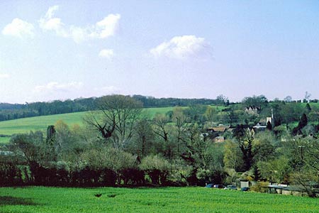
Click image to visit gallery of 8 images.
This Hertfordshire walk starts from a dirt layby on the A4146 (Grid ref TL030116), the Hemel Hempstead to Leighton Buzzard Road. The layby is opposite 4 blocks of houses on the right hand side of the road coming from Hemel Hempstead just after passing the turning signed to Great Gaddesden and with a large Wyvale Garden Centre notice. Coming from Leighton Buzzard, after passing the crossroads with lanes going off to Little Gaddesden and Studham look out for Bradden Lane on the left: the houses are soon after on the left with the layby opposite.
As you face the houses there is a footpath at the right hand end signed Gaddesden Row 11/2: this is the Hertfordshire Way but not signed as such going this way. Cross the A4146 and go up this concrete drive and continue up the field edge curving left. Where the field edge turns sharp right continue straight on over the field up to the wood at the top. Enter the wood and immediately turn right. The track goes along just inside the wood (bluebells in season), and emerges through a kissing gate to go along a field edge with woods on the left. Go through a double set of gates and follow the fence on right straight on through two fields to arrive at a large house (The Hoo) sitting in a parkland designed by Capability Brown. Here bear left to a gate and stile in the hedge a short distance off. Once over the stile, turn right along a hedge; where the hedge ends, continue straight on across a field to a gap in the hedge on the opposite side. Continue straight across another field aiming for the right hand end of a line of trees. Here go through a kissing gate and bear slightly right to come to a stile by a gate and tree. Once over the stile continue down an enclosed path - abandoned allotments on left - and come out at a (Roman) road (Grid ref TL042136).
Turn left along the pavement and at the edge of Jockeys End turn right onto public footpath 9 through a children's play area, and afterwards along the backs of houses and down a field break to steps down to a gravel lane in Ballingdon Bottom (a dry valley). Turn right and follow it out to a lane and immediately turn left through a wooden kissing gate. Cross the field up to a gate to the left of a line of poplars. Turn right and walk along the edge of Beechwood House School playing fields. The site of Beechwood House has a history going back to the Domesday Book, but the present house (now school) is a 1702 red brick Georgian mansion originally in parkland by Capability Brown the features of which are still discernible. At the end of the playing fields follow the path through a coppice to come to the school drive.
Here leave the Hertfordshire Way by turning right and following the drive past a Victorian Lodge out to a road. Turn right; ignore the road immediately to the right (signed Gaddesden Row) and go up the hill (the road carries some traffic so it is sensible to keep to the right and walk single file but sight lines are good) and along for about 1/2 mile. Watch out for a Chiltern Way sign pointing left and straight on, then in about 100 yds turn right at a second Chiltern Way sign (Grid ref TL055136)
Now follow the Chiltern Way to Water End. Start by going down by the side of a woodyard to come quickly into a long field with woods either side. There is no obvious trodden path, but first of all you need to arrive at the far corner of the left hand wood and then, going forward, a gate in the hedge ahead. Go through the gate and turn left down a green lane which, after a gap leading to fields on either side, swings right and then goes straight to the JMI school at Gaddesden Row. There is a pub about 1km to the left, but the walk continues straight on over the (Roman) road down a tarmac drive. Just before a large black and white timbered farm house turn left along a field edge. At the field corner turn right down an enclosed footpath to a kissing gate facing Golden Parsonage, built in 1706 but with nearby fishponds suggesting an earlier medieval building. From the gate bear right and continue through a gate on this line over two fields to arrive at the drive into the Parsonage. Bear slightly right again to follow the drive towards Home Farm for about 1/2mile before diverging right to follow the track through the woods to bypass the farm. Where you emerge from the woods by a wide gate there are glorious views over the Gade valley. You walk down to a line of power line poles and follow them across the parkland to a gate and stile. Cross the stile and walk up beside the fence. Pass an original estate gate left remaining in the modern fence and turn right through the next gate. Go straight ahead to a double and single gate in the fence ahead. Go straight ahead from the gate and when level with the architect Wyatt's Palladian villa, Gaddesden Place, bear left through the parkland to a single gate in the fence running down hill on the left . (Great view over Great Gaddesden.) From here, bear right through a clump of 5 mature trees to another gate. From here there is a good view of the 17th Century brick and timber cottage which comprise the hamlet of Water End and it is a straight line down to the cream gable end of a cottage to the right. To the left of the cottage is a wicket gate which decants you directly onto the A4146 (Grid ref TL035107). Take great CARE in coming out onto the road and in crossing it - it is busy and with restricted sight lines to the left.
Once you are safely across turn right for a few yards and then left down a very narrow footpath between buildings to a kissing gate. From the gate cross the river Gade by the bridge and continue your line over the water meadows to a power line pole in the corner of the field. Go through a gate, turn right along a field edge and an enclosed path to arrive at a road in Great Gaddesden near its 12th Century church. Go down Church Meadow opposite, fork right past the school on left and where the road bends left, go straight on to find a kissing gate on the right. Go through this, over the water meadow to the long bridge over the Gade and up to the A4146 at your starting point.
Other walks nearby
| Walk 1833 | Great Gaddesden from Jockey End | easy | 5.2 miles |
| Walk 1504 | Potten End Circular | easy/mod | 6.0 miles |
| Walk 3503 | Circular from Berkhamsted | easy | 4.0 miles |
| Walk 1297 | Berkhamsted and Northchurch Commons | easy | 5.0 miles |
| Walk 1399 | Berkhamsted & Northchurch Commons | easy | 5.5 miles |
| Walk 1007 | The Ashridge Estate circular | easy/mod | 6.0 miles |
| Walk 3097 | Markyate and Flamstead Circular | easy/mod | 7.0 miles |
| Walk 2907 | Hemel Hempstead Circular | easy | 6.5 miles |
| Walk 3537 | Hemel Hempstead, Great Gaddesden, Nettleden & Potten End | moderate | 10.8 miles |
| Walk 1999 | The Chilterns above Tring | moderate | 12.0 miles |
Recommended Books & eBooks
No suggestions for this area.Messaging & Social Media
Message Walking Britain and follow the latest news.

Mountain Weather
Stay safe on the mountains with detailed weather forecasts - for iOS devices or for Android devices.