Stoodley Pike & Withens Clough Reservoir from Lobb Mill
South Pennines Walk
Region - South Pennines
County/Area - West Yorkshire - South Pennines
Author - Allan Friswell
Length - 9.0 miles / 14.6 km Ascent - 1700 feet / 515 metres
Time - 6 hours 10 minutes Grade - moderate
Maps 

| Ordnance Survey Explorer OL21 | Sheet Map | 1:25k | BUY |
| Anquet OS Explorer OL21 | Digital Map | 1:25k | BUY |
| Ordnance Survey Landranger 103 | Sheet Map | 1:50k | BUY |
| Anquet OS Landranger 103 | Digital Map | 1:50k | BUY |
| Ordnance Survey Landranger 104 | Sheet Map | 1:50k | BUY |
| Anquet OS Landranger 104 | Digital Map | 1:50k | BUY |
Walk Route Description
Click image to visit gallery of 7 images.
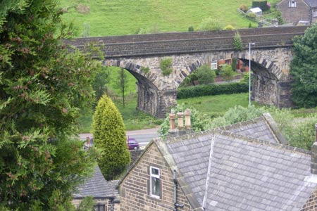
A walk full of breathtaking scenery, taking in not only Stoodley Pike but Withens Clough reservoir, and following the Pennine Bridleway, the Pennine Way and the Calderdale Way. The start is the car park at Lobb Mill (grid ref. SD955246) on the A6033 Todmorden to Hebden Bridge road. The start can also be reached by buses and trains, although the latter would add just under 3 miles (5 km) to the length of the walk.
After parking cross the road and walk towards Todmorden, passing the great arches of the railway viaduct. Turn left along Haugh Road. Cross the canal, heading steeply uphill. At the end of the terrace of houses, climb the steps and go through the gate. The path now zigzags steeply, affording a fine view of the canal and the railway arches. Cross the stile, turn right and continue uphill. Over a second stile and follow the right hand side of the field. The "path" is clearly rarely walked and is obscured by grass. Watch your ankles. After the next stile, keep ahead to the stile in the corner (SD955240). Keep to the left of the next field, negotiate the gap in the wall and make for the stile ahead.
The obvious track now goes downhill meeting the tarmacked road at Mankinholes Bank. Descend this into Mankinholes village. As you walk through this hamlet you pass the Old Sunday School on your left. Turn left along the signed Pennine Bridleway, also called London Road, which you follow for a good while ascending very slightly until you meet the sign for the Pennine Way (grid ref. SD980247), climbing to your right. Follow this steeply uphill, turn right at the next stile, negotiate the squeeze stile and climb to the monument.
The site on Stoodley Pike (which is the name of the hill rather than the monument) was probably used for Bronze Age burials, since bones were found when excavating for the first circular tower. This was built in 1815 entirely by public subscription, to celebrate the peace at the end of the Napoleonic war. Unfortunately, it collapsed in 1854 following a lightning strike on the day the Russian ambassador left London before the Crimean War. The present monument, 120 feet high and 1310 feet above sea level, was built in 1856 to celebrate the end of the Crimean War, and a lightning conductor now ensures the monument will not suffer further harm. You can climb up the inner spiral staircase counting 39 steps in the dark to get a great view. Stoodley Pike may also have been a beacon site. A beacon was temporarily put up and lit on 19th July 1988 to commemorate the great chain of beacons 400 years earlier, when the Spanish Armada was sighted off the southern coast.
Once you have had your fill of the splendid views (Heptonstall Church, resting place of the poet Sylvia Plath, can be seen in the far distance to the NE), retrace your steps to the stiles but then keep ahead, crossing often boggy ground, making for the stile which takes you into the obvious stand of conifers (grid ref. SD979242). Walk through these. You arrive at a sign post indicating a Permissive Path (grid ref. SD990240). Go over the stile and walk along the walled green lane, turning right at its end. The path soon veers to the right at grid ref. SD999241. After 50 yards cross the stile on the left, and go downhill through the field, keeping the wall on your right. Cross the very awkward stile, turn right down the lane which will lead you to the reservoir, passing the hideous disused blockhouse of Yorkshire Water, passing through a gate and coming to the reservoir. A good place for lunch.
Now cross the dam, turn right at the end and follow the path round with the water on your right. You will finally come to a gate where you turn left along a pretty obvious green path, keeping the wall to your left. The path soon veers right but remains reasonably clear and you will soon come across a much more obvious track, which you follow uphill. The track soon swings left but you maintain your line uphill past a waymarker post, over a low wall, now following the stone foundations of an old wall - again, watch your footing. At the hilltop you reach the signed Calderdale Way at grid ref. SD971229. Follow this uphill.
At grid ref. SD962230 you come to the "Te Deum" stone. The full inscription on its side is "Te Deum Laudamus" - and it was past here that coffins were carried to the church from the now long drowned settlements in Withens Clough. The path ahead is obvious, but four tall marker stones make it even clearer. Soon the path becomes paved, a causeway in fact, a former packhorse route presumably to the Withens settlement, and it starts to descend more steeply. It crosses the Pennine Way at Withens Gate (grid ref. SD967231). Keep going downhill, admiring the way the worn stones have kept in place all these many years. A gate leads to a walled green lane which comes to a wide tarmacked road. Walk left downhill, passing the remains of the Three-tier Watermill, now the Lumbutts Centre.
Here two dams fed three water wheels, one below the other in the tower of Lumbutts Mill. Together they generated 54 horse power. The tower is still there, together with its spiral staircase, but the mill and the wheels have gone. Just after this take the short steep bridleway on the right up to the Top Brink pub at the top. Turn left and passing Brink Top Cottage follow the setted path which remains obvious as you soon pass what five years ago was a waste disposal site and which is now grassed and treed over with only the little iron chimneys releasing the methane gas revealing the site's past.
The path continues downhill, and soon comes to the canal bridge at grid ref. SD951244 which you cross and then descend extremely steep steps to the towpath. Keeping the canal on your right walk to the next bridge and lock where you leave the path (grid ref. SD953246). Cross the main road, (recognise those arches?), turn right and head back the short distance to the car park.
Other walks nearby
| Walk 1411 | Walsden & Warland Reservoir | easy/mod | 6.5 miles |
| Walk 3719 | Ramsden Wood & Hades Hill from Walsden | easy/mod | 6.1 miles |
| Walk 1291 | Stoodley Pike | moderate | 11.0 miles |
| Walk 2121 | Crimsworth Dean, Lumb Bridge & Hardcastle Crags | moderate | 7.5 miles |
| Walk 2606 | Hoof Stones Height, Noah Dale and Colden Water | moderate | 11.5 miles |
| Walk 1849 | Blackstone Edge and the Pennine Way without a car | moderate | 8.0 miles |
| Walk 2260 | White Hill from Hollingworth Lake | moderate | 11.2 miles |
| Walk 1626 | Luddenden Foot Circular | easy/mod | 7.5 miles |
| Walk 1458 | The Rossendale Way from Greave | easy/mod | 7.0 miles |
| Walk 2183 | Irwell Sculpture Trail | easy | 4.5 miles |
Recommended Books & eBooks
Pennine Way Map Booklet
 Map of the 270 miles (435km) Pennine Way National Trail, between Edale in the Peak District and Kirk Yetholm in the Scottish Borders. This booklet is included with the Cicerone guidebook to the trail, and shows the full route on Ordnance Survey 1:25,000 maps. This popular long-distance route typically takes three weeks to complete.
More information
The Pennine Way - the Path, the People, the Journey
 A portrait of the The Pennine Way, Britain's oldest and best known long-distance footpath, stretching 268 miles from the Peak District to the Scottish Borders. This personal, thoughtful and often humorous story of the path's remarkable history, includes the experiences of walkers and local characters on this exhilarating and complex path.
More information
Messaging & Social Media
Message Walking Britain and follow the latest news.

Mountain Weather
Stay safe on the mountains with detailed weather forecasts - for iOS devices or for Android devices.