Northern Carneddau from Abergwyngregyn
Snowdonia/Eryri Walk
Nat Park - Snowdonia - Eastern Carneddu
County/Area - Gwynedd
Author - Lou Johnson
Length - 12.0 miles / 19.5 km Ascent - 3720 feet / 1127 metres
Time - 9 hours 40 minutes Grade - mod/hard
Maps 

| Ordnance Survey Explorer OL17 | Sheet Map | 1:25k | BUY |
| Anquet OS Explorer OL17 | Digital Map | 1:25k | BUY |
| Ordnance Survey Landranger 115 | Sheet Map | 1:50k | BUY |
| Anquet OS Landranger 115 | Digital Map | 1:50k | BUY |
Walk Route Description
Click image to see photo description.
This Snowdonia (Eryri) walk takes in some of the less visited summits of the northern and central Carneddau including three summits over three thousand feet. Because of this you should not treat this walk as a simple excursion into the hills. In addition not all of the route follows clear paths so it is recommended you chose a day with good visibility. Cloud dropping onto the summits is always a problem so the ability to use a map and compass is essential. Finally remember this part of the Carneddau offers few places to shelter in poor weather. However there is a purpose-built stone shelter near the summit of Foel Grach but bear in mind this is the furthest point from the start so it is a long way back to your transport.
The start is the Forestry Commission car park (grid ref. SH664719) a mile or so south of Aber village (located just off the A55 North Wales coast road). This parking area can be quite busy as its main use is for visitors making the short walk to Aber Falls. Alternative parking is available towards the village but this adds unwanted extra mileage to the total.
From the car park take the track that heads south to Aber Falls on the eastern side of the Afon Rhaeadr-fawr. Stay with the main path along the river to reach a footbridge at the base of the falls. Go over the footbridge and follow the path alongside the fence as far as Afon Garn. Just after this stream cross the fence by using a dilapidated stile (grid ref. 662700) and head southwest. Select the best route climbing steadily over rough ground on an intermittent path to the col immediately east of the summit of Gyrn.
Reaching the col at a junction of paths (grid ref. 653690) turn southeast along the clear path that leads to Garnedd Uchaf. Immediately ahead lies Drosgl with the main route contouring across the side of this rounded top. To reach the summit leave the main path and complete an easy ascent. The reward is good views north to Anglesey and also west to the Glyders. The most interesting route from here to Garnedd Uchaf is to head for Bera Bach, an obvious rocky top under a kilometre away to the east. There is no clear path but the route is obvious. Continuing the next objective is Bera Mawr with its rocky crags and a position overlooking Cwm yr Afon Goch. These twin summits see few walkers and provide perfect places to spend some time.
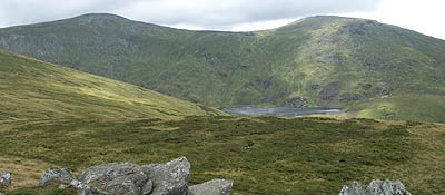
The onward route continues to Garnedd Uchaf, which lies about two kilometres away in a south-easterly direction. The best route is a beeline aiming just to the south of the rocky eminence of Yr Aryg eventually picking up a clear path on the final section to the summit. Continuing walk south on a clear path to Foel Grach with its shelter. From here the views are superb especially across to Yr Elen and Carnedd Llewellyn.
Starting the return route retrace your steps to Garnedd Uchaf from where a path leads northeast to Foel-fras. This section along the ridge provides superb easy walking with good views on both sides. Descend from Foel-fras in a north-easterly direction leaving the main path to descend more steeply to the reach the eastern shores of Llyn Anafon and an access track (grid ref 700699). Some sections of this descent are on paths but subject to weather you can see the track from some distance so navigation is not a problem. Reaching the track head downhill for just under two kilometres until an obvious path forks off and down to your left (grid ref. 685712). Take this path, which follows the eastern bank of the Afon Anafon to reach a lane (grid ref. 676716). All that remains is to follow this lane downhill to the start.
Other walks nearby
| Walk 2346 | Yr Orsedd ridge from near Bont Newydd | moderate | 4.8 miles |
| Walk 2833 | Moel Faban, Gyrn & Moel Wnion from Rachub | easy/mod | 5.0 miles |
| Walk 2547 | Carnedd Llewelyn from near Rowen | mod/hard | 12.0 miles |
| Walk 2115 | Yr Elen, Carnedd Llewellyn & Carnedd Dafydd | hard | 9.5 miles |
| Walk 3051 | Yr Elen from Gerlan | hard | 6.5 miles |
| Walk 3052 | Yr Elen & Carnedd Dafydd from Gerlan | hard | 9.0 miles |
| Walk 1315 | Drosgl and Gyrn Wigau from Rachub | moderate | 7.5 miles |
| Walk 3061 | Eastern Carneddau from near Rowen | mod/hard | 10.5 miles |
| Walk 2497 | Druid Circle, Moelfre and Foel Lus from Penmaenmawr | easy/mod | 6.0 miles |
| Walk 2558 | Carnedd Dafydd & Pen yr Ole Wen from Bethesda | mod/hard | 8.0 miles |
Recommended Books & eBooks
The Cambrian Way
 Guidebook to the Cambrian Way, a challenging three-week mountain trek through Wales from Cardiff to Conwy. The 470km un-waymarked route is presented from south to north. Often sticking to long, beautiful ridgelines, it crosses wild and rugged terrain and visits many of Wales's highest mountains, including Snowdon.
More information
The Wales Coast Path
 A single guidebook to walking the whole Wales Coast Path - 1400km (870 miles) the length of Wales from Chester to Chepstow, including Anglesey, described in 57 stages. The route passes through the Snowdonia and Pembrokeshire National Parks and many AONBs and can be linked with the Offa's Dyke Path for a complete circuit of Wales.
More information
Messaging & Social Media
Message Walking Britain and follow the latest news.

Mountain Weather
Stay safe on the mountains with detailed weather forecasts - for iOS devices or for Android devices.