Rylstone Edges & Cracoe from Rylstone
Yorkshire Dales Walk
Nat Park - Yorkshire Dales - Lower Wharfedale
County/Area - North Yorkshire
Author - Allan Friswell
Length - 6.0 miles / 9.8 km Ascent - 1100 feet / 333 metres
Time - 4 hours 10 minutes Grade - easy/mod
Maps 

| Ordnance Survey Explorer OL2 | Sheet Map | 1:25k | BUY |
| Anquet OS Explorer OL2 | Digital Map | 1:25k | BUY |
| Ordnance Survey Landranger 98 | Sheet Map | 1:50k | BUY |
| Anquet OS Landranger 98 | Digital Map | 1:50k | BUY |
Walk Route Description
Click image to visit gallery of 8 images.
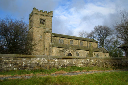
You start this Yorkshire Dales walk in Rylstone, home of the original WI Calendar Girls, your car probably parked close by their 1994 tree by the pond (grid ref. SD969586). From here cross the main road and head up the lane opposite, passing the Manor House on the right (whose Spring gardens are full to bursting with snowdrops) and make for the church. Just beyond this turn right along a rough track, which you follow across a couple of fields to a second clear track. Turn left and follow this track to a gate on the left - the access area entry point. Follow the track through the reedy pasture, climbing steeply past a small plantation to a gate. From here the access area proper is entered. Continue up the track and when you arrive at a gate turn sharp left and walk up to the summit, keeping the wall on your left. From here make your way to Rylstone Cross. (Try as I may I cannot find any online history to portray the cross, only that it was rebuilt in 1995!)
Walk along the moor-side (east) of the wall following a well-worn path which undulates but gradually climbs the extra 350' to reach another stile giving access to the obelisk after about 20 minutes. This is Cracoe's memorial to their men who died in the two World wars, with their names carved into the Yorkshire gritstone. As from the Cross, the views are magnificent.
The next bit is trickier as it is not marked on the OS map. Head along the slope from the obelisk parallel with the wall over to the right, along a faint trod. This, after a couple of hundred yards, turns sharply left, and becomes much more defined, a huge sled groove down which stone was one transported. The descent becomes very steep indeed before approaching a marshy area of taller grasses. You can try following the apparently obvious path ahead, but my advice is, before you reach this Slough of Despond, you should leave the path and skirt left around the top of this marshy area. You will come to a small stream after about 100 yards - cross it and turn right. You should be opposite a distant walled green lane (see picture). At this point you should be able to walk relatively unscathed by deep water to the sheep pens and gates to the lane.
The green lane shortly becomes a farm track. At a cottage it becomes surfaced and just before reaching the main road, at the access point notice, you turn left along a narrow lane. Go right at its end, then sharp left again as it runs behind the 'Devonshire Arms'. At a junction at the end keep straight on alongside a stream. At the main road, turn left and follow the walled lane of Chapel Lane. This quickly levels out and makes towards Rylstone. By the trees at the end take the gate ahead. Proceed along the wall side to Manor House Farm on the right and ponds on the left. From a gate at the end the lane-head at the start of the walk is rejoined. Follow it back past the church to the pond.
Other walks nearby
| Walk 3107 | Flasby Fell from Flasby | easy/mod | 6.5 miles |
| Walk 1576 | Embsay Reservoir | easy | 1.0 miles |
| Walk 1701 | Bordley Hall & Malham Moor from Threshfield Moor | easy/mod | 7.0 miles |
| Walk 2066 | Winterburn Reservoir circular | easy | 6.0 miles |
| Walk 1292 | Linton & Thorpe Fell & Cracoe | moderate | 9.0 miles |
| Walk 1407 | Thorpe & Burnsall from Linton | easy/mod | 6.2 miles |
| Walk 1811 | Sharp Haw in Airedale | easy/mod | 7.0 miles |
| Walk 3307 | Gargrave to Flasby | easy/mod | 6.5 miles |
| Walk 1145 | Grassington, Mastilles Lane & Conistone Dib | moderate | 11.3 miles |
| Walk 1645 | Grassington, Mastilles Lane & Conistone Dib | moderate | 12.0 miles |
Recommended Books & eBooks
Walking in the Yorkshire Dales: South and West
 Part of a two-book set, this guidebook describes 44 walks in the southern and western Yorkshire Dales, including the famous 23 mile Three Peaks circuit over Pen-y-Ghent, Whernside and Ingleborough. The other, mostly circular routes of 3½ to 13 miles cover the scenic region between Sedbergh, Kirkby Lonsdale, Settle, Skipton and Grassington.
More information
Walking in the Yorkshire Dales: North and East
 This guidebook contains 43 circular day walks in the north and east Yorkshire Dales. It explores the dales, hills and moors between Kirkby Stephen and Pateley Bridge. Walking ranges from gentle 3 mile strolls to more strenuous day-long rambles across the Howgills, Wensleydale, Swaledale, Nidderdale, Mallerstang and Coverdale.
More information
Messaging & Social Media
Message Walking Britain and follow the latest news.

Mountain Weather
Stay safe on the mountains with detailed weather forecasts - for iOS devices or for Android devices.