Roseberry Topping & Highcliff Nab from Eston
North York Moors Walk
Nat Park - North York Moors - North York Moors West
County/Area - Redcar and Cleveland
Author - Jim Farrow
Length - 14.3 miles / 23.2 km Ascent - 2100 feet / 636 metres
Time - 9 hours 10 minutes Grade - moderate
Maps 

| Ordnance Survey Explorer OL26 | Sheet Map | 1:25k | BUY |
| Anquet OS Explorer OL26 | Digital Map | 1:25k | BUY |
| Ordnance Survey Landranger 93 | Sheet Map | 1:50k | BUY |
| Anquet OS Landranger 93 | Digital Map | 1:50k | BUY |
| Ordnance Survey Landranger 94 | Sheet Map | 1:50k | BUY |
| Anquet OS Landranger 94 | Digital Map | 1:50k | BUY |
Walk Route Description
Click image to visit gallery of 9 images.
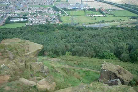
Living in Eston I count myself lucky to have the North Yorkshire Moors more or less right in my backyard, although the fence ( the Eston Hills) take a little getting over. However once over the hill you find yourself on Eston Moor with great views towards the south and the not too distant North York Moors. One of my favourite day walks (and it definitely takes me a good day with an 8.00am start) starts from the The Flatts Lane Country Park car park (Grid ref. NZ564191).
From the car park, cross the road and follow the path all the way up to Eston Nab from where there are excellent views across Teesside and also south. If you feel you have time then an exploration of the old mine workings is worthwhile. From the Nab (Grid ref. NZ568183) I generally follow one of a few paths south west to pick up the Tees Link at either grid ref. NZ560171 or NZ566170. Stay on the 'Tees Link', which is well marked, down to the Cross Keys Public House. Be careful here, after an hour or so of gentle meandering and solitude it's a bit of a sensory overload to be faced with traffic at motorway speeds!
Cross the dual carriageway and pick up the 'Tees Link' again. Continue on until you reach the disused railway (Grid ref. NZ568151) where a stop for refreshments at the picnic table has been earned. For now we bid farewell to the Tees Link (we'll pick it up later). Use the steps over the fence and head south/south easterly along footpaths and tracks, passing Low Farm and Spite Hall Farm, heading towards the A173 and another road crossing, beware!
Having safely negotiated the road, head up to and past Mount House Farm making for The Cleveland Way at grid ref. NZ584127. You are now on the North Yorkshire Moors proper. Choices, left or right, east or west. I generally avoid an ascent of Roseberry Topping, too many people this time of day, but its up to you and your legs! After either a conquering the summit or ignoring it, head east and follow The Cleveland Way over Newton Moor and past Hutton Lowcross Woods all the way to Highcliff Nab (Grid ref. NZ610138). Say 'hello' to the Tees Link again and follow it to Pinchinthorpe and back along the disused railway line to the picnic spot and return across the A171 and back to Flatts Lane.
Other walks nearby
| Walk 3160 | Roseberry Topping and Captain Cook's Monument | easy/mod | 6.3 miles |
| Walk 2930 | Roseberry Topping from Newton under Roseberry | easy | 3.2 miles |
| Walk 1330 | Roseberry Topping & Captain Cook's Monument | easy/mod | 6.5 miles |
| Walk 1467 | Cleveland Way - Roseberry Common to Tidy Brown Hill | moderate | 15.0 miles |
| Walk 1050 | Highcliff Nab & Roseberry Topping from Slapewath | moderate | 10.5 miles |
| Walk 2685 | Highcliff Nab and Guisborough Moor | moderate | 11.1 miles |
| Walk 2174 | Warsett Hill from Saltburn-by-the-Sea | easy | 4.3 miles |
| Walk 1468 | Wain Stones, Bank Foot & Bloworth Crossing | moderate | 14.3 miles |
| Walk 1538 | Baysdale Circular | moderate | 9.5 miles |
| Walk 1469 | Carlton Bank, Scugdale, Raisdale & Kirby Bank | moderate | 10.5 miles |
Recommended Books & eBooks
The Cleveland Way Map Booklet
 Map booklet of the Cleveland Way National Trail, a 177km (110 mile) walk around the North York Moors National Park. This booklet is included with the Cicerone guidebook to the Cleveland Way and the Yorkshire Wolds Way, and shows the full route of the Cleveland Way on Ordnance Survey 1:25,000 maps.
More information
Messaging & Social Media
Message Walking Britain and follow the latest news.

Mountain Weather
Stay safe on the mountains with detailed weather forecasts - for iOS devices or for Android devices.