Happy Valley Circular
Snowdonia/Eryri Walk
Nat Park - Snowdonia - Cadair Idris
County/Area - Gwynedd
Author - Donald Morton
Length - 4.2 miles / 6.8 km Ascent - 500 feet / 152 metres
Time - 2 hours 40 minutes Grade - easy
Maps 

| Ordnance Survey Landranger 135 | Sheet Map | 1:50k | BUY |
| Anquet OS Landranger 135 | Digital Map | 1:50k | BUY |
Walk Route Description
Click image to visit gallery of 6 images.
Happy Valley (the Victorian name for Cwm Maethlon) runs east - west behind Aberdovey (which the Victorians developed as a seaside resort) and provides a picturesque route between Machynlleth and Towyn. The walk starts from a car park at Grid Ref SH 640 986. Coming from the Towyn direction it is easy to spot the National Park sign on the right hand side of the lane. From the Machynlleth direction it is about 1km after a burnt-out farm house on the left concealed behind a hedge also on the left at the end of a stretch of narrow lane with high hedges.
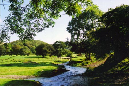
To start this Snowdonia (Eryri) walk, leave the car park and turn left down the lane going down Happy Valley. Turn left at the first opportunity past a cedar wood bungalow and on past stone farm buildings. Cross a stile and over a field and bridge over the Afon Dyffryn-gwyn. Turn right up the track and follow it through and along the edge of woods and over open down land to a track junction. From here to the right are views over Cardigan Bay to the Llyn Peninsula and down the western end of Happy Valley. And as you turn left to follow the track rising gently over the downs there opens up a succession of views looking east up Happy Valley. There is one gate to go through before the track reaches a lane - very quiet since it serves one solitary house. Turn left along the lane.
The views of the Happy Valley continue on the left and, as one approaches the house, views across the Dyfi estuary start to appear on the right. Somewhat before the house the tarmac finishes and the route continues, ignoring footpaths left and right, on past the house and now definitely an ancient trackway. From here one can see right across the estuary to the sand dunes of the Ynyslas Nature Reserve and the marshes providing a wild life sanctuary behind Borth.
Further along there are views right up the valley of the Dyfi to the mountains of its source. Look out for the stone marking Carn March Arthur on the left of the track. Here you can see the indentation made by the hoof of King Arthur's horse when it made a legendary leap across the estuary. A little further on a sign on a gate post indicates that the right of way bears right. However, follow the alternative track which swings left. Ignore a track going right and, after a short rise, descend to Llyn Barfog (The Bearded Lake) to which more Arthurian legends attach. Before descending to the lake turn left, aiming for a gate. From here follow the track down to the farm with views once more down Happy Valley. Follow the track through the farm buildings, bearing right to reach the start car park.
Other walks nearby
| Walk 3230 | Tarrenhendre from Abergynolwyn | easy/mod | 5.0 miles |
| Walk 1643 | Llanfihangel-y-pennant & Castell y Bere | easy/mod | 6.8 miles |
| Walk 3582 | Castell y Bere & Llanfihangel-y-pennant from Abergynolwyn | easy/mod | 5.7 miles |
| Walk 1309 | Tarren y Gesail | moderate | 8.0 miles |
| Walk 1420 | Borth to Aberystwyth coast | easy/mod | 6.5 miles |
| Walk 2570 | Cadair Idris from Llanfihangel-y-pennant | mod/hard | 10.0 miles |
| Walk 2707 | Tyrrau Mawr and Craig-y-llyn from Llanfihangel-y-pennant | moderate | 9.5 miles |
| Walk 1705 | Bont-goch Circular from near Aberystwyth | easy/mod | 4.5 miles |
| Walk 1851 | Cregennen Lakes & Pared y Cefn-hir | easy/mod | 2.5 miles |
| Walk 1204 | Cadair Idris Minffordd Path | mod/hard | 6.0 miles |
Recommended Books & eBooks
The Cambrian Way
 Guidebook to the Cambrian Way, a challenging three-week mountain trek through Wales from Cardiff to Conwy. The 470km un-waymarked route is presented from south to north. Often sticking to long, beautiful ridgelines, it crosses wild and rugged terrain and visits many of Wales's highest mountains, including Snowdon.
More information
Snowdonia: 30 Low-level and easy walks - South
 Guidebook describing 30 walks in Snowdonia, Wales. Routes are mostly low level and on clear paths and showcase the region's beautiful scenery and rich history and culture. Part of a 2-volume set, this southern volume includes Trawsfynydd, Bala, Dolgellau, Machynlleth, the Harlech Coast and the valleys of the Mawddach and Dyfi.
More information
Messaging & Social Media
Message Walking Britain and follow the latest news.

Mountain Weather
Stay safe on the mountains with detailed weather forecasts - for iOS devices or for Android devices.