Temple Guiting & Cutsdean from Stanway
Cotswolds Walk
Region - Cotswolds
County/Area - Gloucestershire
Author - Lou Johnson
Length - 10.0 miles / 16.3 km Ascent - 1350 feet / 409 metres
Time - 6 hours 20 minutes Grade - moderate
Maps 

| Ordnance Survey Explorer OL45 | Sheet Map | 1:25k | BUY |
| Anquet OS Explorer OL45 | Digital Map | 1:25k | BUY |
| Ordnance Survey Landranger 150 | Sheet Map | 1:50k | BUY |
| Anquet OS Landranger 150 | Digital Map | 1:50k | BUY |
Walk Route Description
Click image to visit gallery of 12 images.
The Cotswold Hills between Broadway and Winchcombe offer some fine countryside with rolling hills offering grand views. This walk uses a mixture of tracks and paths to explore the villages of Temple Guiting, Cutsdean and Taddington as well providing an excellent opportunity to explore Stanway with its fine House and Church. As a bonus the walk also includes a section of the Cotswold Way National Trail.
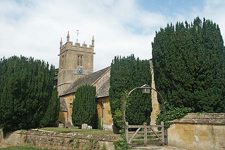
The start is the small Gloucestershire village of Stanway, located between Broadway and Winchcombe. Parking is at a premium and the best spot to park is a small lay-by just to the north of the village (Grid ref. SP060325) where the Cotswold Way leaves the lane bound for Stanton. After parking walk south into the village passing the beautiful church and the grand Gatehouse to Stanway House. Just after the road turns sharp right take the Cotswold Way signed off left. This leads past a blacksmiths workshop to reach the B4077.
Turn left for a few metres and then take the signed Cotswold Way to Wood Stanway. You cross fields to reach the lane in this hamlet. Go left along the lane and continue past riding stables on your right to reach open field (Grid ref. SP065311). The path is well-waymarked as you climb steadily passing Lower Coscombe on your left to reach the B4077 at Stump's Cross. Turn right along the road and immediately right again to join a wide track. You are still on the Cotswold Way and this track is followed for some 3 kms. The Cotswold Way turns right after a kilometre and you should continue straight ahead. Care is needed at one point as a more distinct track goes left. Ignore this and continue straight ahead on the waymarked bridleway.
Reaching a lane (SP064281) bear left a short way to a T-junction. Go left here and walk along the lane past Pinnock Wood Farm. As the road descends look out for a small concrete sign indication "Footpath" on your right. The path is enclosed by bushes and leads you down a shallow valley past the site of the Medieval Village of Pinnock. Go straight across the track leading to Pinnock Farm and descend to the point where the track bends right. Go left here and carefully follow the waymarks across some stepping stones, a couple of stiles and a small bridge to enter woodland. After a few metres turn right uphill (In summer the waymark was hidden in the undergrowth here). The onward path is easily followed through the woodland before descending to a road (Grid ref. SP089281).
Turn right along the road and then first left into Temple Guiting. Just after entering the village, take the signed footpath along the track on your left. This leads you into fields. The path continues with the hedge to your left. As the track bends right, take the path through the large metal gate on your left and continue across more fields to reach the B4077 near Ford. Turn left and walk on the grass verge as far as the pub. Cross the road here and just past the pub car park turn right onto the access road for Jackdaw's Castle. On your right you will see the extensive facilities for training racehorses from this famous stable.
Follow the access road for a short way and take the footpath to Cutsdean signed left. This takes through some paddocks (a different alignment than on some OS maps) to a T-junction of paths. Go right and continue towards Cutsdean where you arrive at a lane. Go straight across the walled field opposite and continue on the right of way through Manor Farm. After crossing one field take care to note the waymarked stile in the hedge on your left (Grid ref. SP088305) which needs to be crossed. Follow the path down into the valley and cross the wooden footbridge and when Taddington comes into view bear half left across the field to a stile. Cross this and turn right along the lane through this hamlet. Manor Farm is on your right and opposite is a waymarked path. Maps show this path to the right of the field boundary but you will find it easier to pick the best side of the derelict wall as crops permit. At a footpath sign (Grid ref. SP081313) bear half right across the field to a stile and a lane.
Go straight over and continue on the same line through another field to reach the edge of a wood. Care is needed on the next section. Just in the wood is a track. Turn left onto this and bear right through a complex junction of forestry tracks. At the next clear junction fork left. This clear track descends through the woods and you should ignore any cross tracks to reach cottages and other buildings close to the B4077 (Grid ref. SP068320). Continue west on the footpath alongside the B4077. Turn right down the Cotswold Way into Stanway and the walk along the road through the village back to your car.
Other walks nearby
| Walk 3063 | Stanway & Snowshill circular | moderate | 8.0 miles |
| Walk 2094 | Snowshill Circular | easy | 4.4 miles |
| Walk 3064 | Hailes, Beckbury & Sudeley from Winchcombe | moderate | 10.0 miles |
| Walk 3065 | Cleeve Common & Belas Knap from Winchcombe | moderate | 10.0 miles |
| Walk 3072 | Broadway, Stanton & Laverton | easy/mod | 7.5 miles |
| Walk 3250 | The Broadway Tower from Broadway | easy/mod | 5.0 miles |
| Walk 1949 | Nottingham Hill | easy/mod | 4.5 miles |
| Walk 1308 | Broadway & Chipping Campden | moderate | 11.0 miles |
| Walk 2168 | The Slaughters | easy/mod | 8.6 miles |
| Walk 2495 | Bredon Hill Circular | moderate | 10.6 miles |
Recommended Books & eBooks
The Cotswold Way
 Guidebook to walking the Cotswold Way National Trail. Between Chipping Campden and Bath, the 102 mile route explores the Cotswolds AONB. Described in both directions over 13 stages, the Cotswold Way can be walked year round and is suitable for beginner trekkers. Includes separate OS 1:25,000 map booklet of the route.
More information
The Cotswold Way Map Booklet
 Map of the 102 mile (163km) Cotswold Way National Trail, between Chipping Camden and Bath. This booklet is included with the Cicerone guidebook to the trail, and shows the full route on OS 1:25,000 maps. The trail typically takes two weeks to walk, and is suitable for walkers at all levels of experience.
More information
Messaging & Social Media
Message Walking Britain and follow the latest news.

Mountain Weather
Stay safe on the mountains with detailed weather forecasts - for iOS devices or for Android devices.