The Three Counties Tops
Chilterns Walk
Region - Chilterns
County/Area - Bedfordshire & Hertfordshire & Buckinghamshire
Author - Barry Mackie
Length - 17.0 miles / 27.6 km Ascent - 2000 feet / 606 metres
Time - 10 hours 30 minutes Grade - mod/hard
Maps 

| Ordnance Survey Explorer 181 | Sheet Map | 1:25k | BUY |
| Anquet OS Explorer 181 | Digital Map | 1:25k | BUY |
| Ordnance Survey Landranger 165 | Sheet Map | 1:50k | BUY |
| Anquet OS Landranger 165 | Digital Map | 1:50k | BUY |
| Ordnance Survey Landranger 166 | Sheet Map | 1:50k | BUY |
| Anquet OS Landranger 166 | Digital Map | 1:50k | BUY |
Walk Route Description
Click image to visit gallery of 12 images.
Known locally as "The Three Counties", Bedfordshire, Hertfordshire and Buckinghamshire all share borders in a region extensively covered by the Chiltern Hills. Although not particularly high, the Chilterns are an attractive range of hills and coincidentally contain the highest points for each of these three counties; locations that are generally described as "County Tops". This walk visits all of these places and also plenty of other superb and interesting sights such as Ivinghoe Beacon, Steps Hill and the obelisk in Tring Park, to name just a few. The whole of the walk is within an Area of Outstanding Natural Beauty (AONB) and much of it is along the Ridgeway National Trail. Note - the attached gpx file includes a diversion into Aldbury for lunch at the Crown!
Extensive parking is available near the impressive Visitor Centre adjacent to the B4541 on Dunstable Downs (grid ref TL007199). The Centre itself is certainly worth a look, with a fine choice of food and drinks and plenty of information on display about the local area. From here it is a short walk up the slope to the trig pillar at Robertson Corner and at 243m/798ft (grid ref TL009194), Bedfordshire's highest point is already "in the bag".
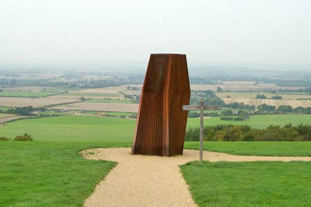
Retrace your steps and head back down the slope, passing the Visitor Centre to reach the rather unusual and imposing metal structure (a cooling tower for the VC) with a waymarker post and obvious path alongside. Turn left onto this path and head southwest, enjoying the panoramic views over the Vale of Aylesbury below you to your right and ahead of you, in the distance, the prominent hill of Ivinghoe Beacon. Continue on this route over the grassy meadow to turn left just before reaching the road and car park (grid ref SP999185). Now head southeast on a fairly narrow track to near a hamlet ahead of you and the Whipsnade Tree Cathedral on your left. Turn left here (grid ref TL005180) and go in a generally westerly direction through the Tree Cathedral to reach the road, with the church in front of you on the far side. Note - The turning into the Tree Cathedral is just so easy to miss. If you do come out into the hamlet, then you missed it too! Now retrace your steps 5 or 6 metres and you will see it.
The path, waymarked here as the Chiltern Way, leads through the church grounds and into a field. Turn right here, almost coming back on yourself and follow the hedgerow around the edge of this field to reach Studham Lane (as marked on your map). Follow this tree lined path in a southeast direction with the Wildlife Park now alongside on your right. Turn right at grid ref TL014173 to stay alongside the boundary of the Park. With any luck you may get a close look at the herd of deer that roam this section. The route continues alongside the Park to reach and then partly cross the golf course. The waymarker posts on the course might not all be easy to locate, but it is not too much of a problem provided you maintain direction (southwest) to turn right before crossing the last fairway. Follow this line and you will leave the golf course with the clubhouse some 30metres alongside you on your left.
Almost immediately into light woodland now, with a wooden fence on the right, you head down a steep slope to reach a minor road (also called Studham Lane) Turn right for a few metres and then left to continue down the slope to reach the main road at the edge of the village of Dagnall. Go right along this road (A4146) through the village to reach and turn into Hog Hall Lane (grid ref SP987165). Follow the lane alongside the field to reach and pass on the left side of Hogg Hall (a private residence) steadily gaining height along the way, to reach Wards Hurst Farm (grid ref SP973153). Turn right and start to head down the slope and into the woods following an obvious path to come out into a field with the Ivinghoe Hills in front of you. The path continues alongside a fence and veering slightly to the left to reach the sharp bend in the road. Go right and up the fairly steep slope to the trig pillar and topograph on the summit of Ivinghoe Beacon This is one of the more rather special places in Southeast Britain with excellent views over the Vale of Aylesbury below. What really gives this place a little more edge though, is looking to the east over Gallows Hill and on to the White Lion carved in the side of Whipsnade Down some 2.5 miles away.
Retrace your steps back down the slope to the road which you cross to follow the signs for the Ridgeway. Initially you walk up another slope and through a short section of woodland to come out on open ground with Steps Hill and Incombe Hole in front of you. The path skirts to the left of these descending to level ground and this is the easiest option, although you can descend the very steep slope of Steps Hill and walk through Incombe Hole if you wish. Cross the road and go straight through the car park and then up and over the small hill in front of you. Note the map and waymarkers send you down the road and around this moderately hilly section. The choice is yours, but either way you will end up back on the correct path.
The route now follows the line of Grimms Ditch, a prominent scar that was probably a regional boundary in ancient times, to reach the brow of Pitstone Hill, just before the woods and the nature reserve of Aldbury Nowers. Follow the path through the woodland, which here is typical of what the Chilterns are renowned for, predominantly mature beech trees. Ignore the first obvious footpath to the right, instead take the second at grid ref SP954124 that follows the edge of the field to reach the road. Go right alongside this road, passing a T-junction, then Tring railway station and finally the bridge over the Grand Union Canal. Immediately past the canal, turn left onto the minor road for approx 100m to turn right, in a southwest direction, initially alongside some riding gallops. Approximately 800m further you will come to a gate alongside the A4251 road. Cross the road veering to the right and take the pedestrian bridge high over the A41 trunk road to reach Beggars Lane.
Turn right for a few metres then left to skirt the southern edge of Langton Wood. You soon pass a trig pillar on the side of the path and looking to your right there will be good views towards Beacon Hill. Go straight across the next road (Oddy Hill) to enter woodlands and Tring Park where a short diversion to the right leads to the interesting obelisk and summerhouse. A nearby information board tells the tale. Retrace your steps back up the slope to continue along a wide path southwest to veer south and leave the park at the road (Marlin Hill). Continue down this road for approx 100m and turn right at the junction to go along the road to reach a sharp left hand bend and the signed entrance to Pavis Wood on your right.
Choose your spot here, no markers, but this is the agreed highest point of Hertfordshire at 244m/802ft (generally accepted as grid ref SP914092). Follow the wide (and usually muddy) unmade track that runs parallel to the boundary of the woods to come out at the road (grid ref SP905085). Cross the road veering to the right leaving the Ridgeway trail to go in a westerly direction to reach another road. Turn left for 150m, then follow the waymarker that leads right into the field in a northwest direction to reach the woods at the far side. Take the left fork here and maintain direction (WNW) to reach the visitor centre and cafeteria complex. You should pass the summit cairn showing the highest point of both the Chiltern Hills and Buckinghamshire at grid ref SP890089. If you miss it do not worry as it is also clearly signposted from near the visitor centre
Notes There are many dedicated footpaths that cross or form part of this route and from Dunstable Downs, this walk is well signed as the Ridgeway Link, heading to Ivinghoe Beacon, the start/finish point of the Ridgeway National Trail. Sadly this signage is only in place until you leave the downs at Whipsnade (2008), so do not rely on it too much. From Ivinghoe Beacon until almost the finish of the walk at Wendover Woods, the waymarkers will state "Ridgeway" or have an acorn motif. If you prefer to do this walk in two sections, then Tring Railway Station is the logical half way place
Transport This is a linear walk and easiest done using two cars. If you need to use public transport from Wendover Woods back to Dunstable Downs, then getting a taxi from Wendover is probably the easiest option. The Wendover Woods car park is locked at 8.00pm
Other walks nearby
| Walk 2316 | Dunstable Downs Circular | easy | 4.0 miles |
| Walk 3089 | Dunstable Downs & Totternhoe from Robertson Corner | easy/mod | 8.8 miles |
| Walk 3124 | Five Knolls & Totternhoe from Robertson Corner | easy/mod | 6.0 miles |
| Walk 3125 | Whipsnade & Codling Bank from Robertson Corner | easy | 4.3 miles |
| Walk 1833 | Great Gaddesden from Jockey End | easy | 5.2 miles |
| Walk 1999 | The Chilterns above Tring | moderate | 12.0 miles |
| Walk 2399 | The Chilterns above Tring (short version) | easy/mod | 8.0 miles |
| Walk 2064 | Ivinghoe Beacon from the Ashridge Estate | easy/mod | 6.5 miles |
| Walk 3025 | Ashridge Estate Circular | easy | 4.5 miles |
| Walk 1007 | The Ashridge Estate circular | easy/mod | 6.0 miles |
Recommended Books & eBooks
No suggestions for this area.Messaging & Social Media
Message Walking Britain and follow the latest news.

Mountain Weather
Stay safe on the mountains with detailed weather forecasts - for iOS devices or for Android devices.