The Ashridge Estate circular
Chilterns Walk
Region - Chilterns
County/Area - Hertfordshire & Buckinghamshire
Author - Tony Harding
Length - 6.0 miles / 9.8 km Ascent - 700 feet / 212 metres
Time - 3 hours 40 minutes Grade - easy/mod
Maps 

| Ordnance Survey Explorer 181 | Sheet Map | 1:25k | BUY |
| Anquet OS Explorer 181 | Digital Map | 1:25k | BUY |
| Ordnance Survey Landranger 165 | Sheet Map | 1:50k | BUY |
| Anquet OS Landranger 165 | Digital Map | 1:50k | BUY |
Walk Route Description
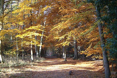
Click image to visit gallery of 5 images.
This woodland walk is very pleasant at any time of the year but is at its best in early May, when the bluebells and cowslips are in full bloom. An easy walk with only one steepish climb, at the end of the walk. Ashridge Estate is owned by the National Trust and located in west Hertfordshire, about 3 miles north of Berkhamsted.
From the car park (half way between the monument and the B4506 road at Grid ref. SP976128) walk towards the Monument for about 150 yards and turn right at the Public Footpath sign, follow the path to the cross-junction by a large dead tree (not too obvious in winter!) and turn right. At the second path junction the path bears slightly left (NE). Follow this wide straight track for about 15 minutes, until the path ends at some houses. Go left here and after about 3 or 4 minutes take the wide grass track on the right to bring you out into the large open grass car parking area at Ringshall.
Bear right to the center of the grassed area, with the car park entrance (opposite the terraced houses in Beacon Road) on your right, walk towards the left of the fallen tree. Find and follow the path, which goes parallel with and about 100 yards from the road. The path is not too clear in places so keep the road and passing cars on your right (or follow the roadside itself if you're not too sure). After some 10 minutes turn right where a large fallen tree blocks the path, this brings you to a small car park area opposite Dockey Wood. Cross the road and walk around the inner perimeter path through a spectacular display of bluebells (early May), to exit the woods and rejoin the road some 200yards from where you entered the wood.
Cross the stile immediately on your right to walk diagonally across the field to a stile to the right of the oak tree, follow across the next field, and then go right along the farm track. In the center of Wards Hurst farmyard bear left to a stile opposite the pond, do not enter the woods. Cross the field bearing right towards the trees, cross a stile beside a gate and follow the woodland edge to rejoin the Beacon road again. Cross the road and view the bluebells in Crawley Wood, less popular than Dockey Wood but equally spectacular.
Exit the wood and go left along the roadside, cross the cattle grid then turn left onto the wide stony track to Clipper Down. Stay on the track, climbing up through woods to a gate on the right, some 50 yards before the Clipper Down dog kennels. There are fine views on the right across to the Tring Reservoirs and Aylesbury beyond. Take the downhill public footpath, which forks, to the right, crossing two stiles. Another glorious view at this point beneath the small clump of pine trees. The hillside in front is a mass of yellow cowslips (early May). Follow the wide path around the hill to emerge at a lane, go left to the entrance to Duncombe Farm. Follow the public footpath on the right crossing diagonally a couple of fields to a small track.
Leave the footpath and bear left along the track, which climbs fairly steeply up through woodland. When a house is reached on the right, leave the track and take the left-hand footpath at a wooden barrier. A main wide track is soon reached, bear right along this track which will bring you to the 108ft tall Bridgewater Monument, erected in 1832 in honour of the 3rd Duke of Bridgewater and his pioneering work on British canals, in particular the Grand Union canal nearby. Time for a welcome cup of tea at the NT Visitors Centre and cafe opposite. The car park is a few hundred yards down the main Monument Drive.
Other walks nearby
| Walk 1999 | The Chilterns above Tring | moderate | 12.0 miles |
| Walk 2399 | The Chilterns above Tring (short version) | easy/mod | 8.0 miles |
| Walk 2064 | Ivinghoe Beacon from the Ashridge Estate | easy/mod | 6.5 miles |
| Walk 3025 | Ashridge Estate Circular | easy | 4.5 miles |
| Walk 2071 | Ivinghoe Beacon and Bridgewater Monument from Tring | easy/mod | 8.0 miles |
| Walk 2496 | Cow Roast and Aldbury from Tring Station | easy | 5.5 miles |
| Walk 3503 | Circular from Berkhamsted | easy | 4.0 miles |
| Walk 1297 | Berkhamsted and Northchurch Commons | easy | 5.0 miles |
| Walk 1399 | Berkhamsted & Northchurch Commons | easy | 5.5 miles |
| Walk 3098 | Tring & Wendover Woods | easy/mod | 7.5 miles |
Recommended Books & eBooks
No suggestions for this area.Messaging & Social Media
Message Walking Britain and follow the latest news.

Mountain Weather
Stay safe on the mountains with detailed weather forecasts - for iOS devices or for Android devices.