Blencathra via Sharp Edge from Scales
Lake District Walk
Nat Park - Lake District - Lake District Northern Fells
Wainwrights - Blencathra
County/Area - Cumbria
Author - Lou Johnson
Length - 5.0 miles / 8.1 km Ascent - 2100 feet / 636 metres
Time - 4 hours 40 minutes Grade - mod/hard
Maps 

| Ordnance Survey Explorer OL5 | Sheet Map | 1:25k | BUY |
| Anquet OS Explorer OL5 | Digital Map | 1:25k | BUY |
| Ordnance Survey Landranger 90 | Sheet Map | 1:50k | BUY |
| Anquet OS Landranger 90 | Digital Map | 1:50k | BUY |
Walk Route Description
Click image to visit gallery of 3 images.
Blencathra is an iconic mountain and the approach via Sharp Edge is the most technically difficult. Requiring a head for heights, the route needs to be treated with respect especially in high winds and under ice and snow. Over the years there have been a number of accidents including fatalities and this should be taken into account when selecting this route.
The walk starts from near Scales Farm. Park in one of the lay-bys on the A66. At busy times of the year you may have to park some way from Scales. Once parked, take the short footpath (Grid ref NY340267) that provides access beyond the intake wall and onto the fell. Once through the wall, turn right and begin to climb almost immediately with the intake wall on your right. In recent years there have been some path diversions and realignments so maps may not always be too accurate. At grid ref. NY344273 the path leaves the wall and turns north. Follow the path past some crags ignoring paths turning right and left off the main path. Once past the crags, marked as Level (dis) on OS maps, the gradient begins to ease and you reach a broad grassy col between Scales Fell and Souther Fell with Mousthwaite Comb to your right.
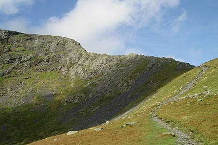
Do not descend to the River Glenderamackin; instead follow the clear path that heads north-west across the eastern flank of Scales Fell. This gains height steadily offering views ahead to Sharp Edge. At the junction of paths (Grid ref. NY333282), fork left and start the climb up to Scales Tarn. Reaching the Tarn, take the less defined path that heads half right and continues climbing up to Sharp Edge. There are a number of paths along the edge with many preferring to take the highest line along the crest. The main path has one obstacle where a rock appears to impede progress. However with a little care this can soon be overcome, with many people sitting down to cross the smooth slab below the overhang. In general Sharp Edge is not for those who suffer from vertigo. It is also worth noting that there are no straightforward routes along the ridge so scrambling cannot be avoided. Also there are a couple of awkward moves that require some agility.
Having completed the traverse of Sharp Edge, you are faced with a steep and rather unpleasant climb towards the summit of Foule Crag. This ascent starts on rock but the way ahead deteriorates and you have to struggle up through loose scree. However, most forget about this inconvenience after the exhilaration of Sharp Edge. Reaching the top, turn left and follow the broad path towards the trig point on Hallsfell Top. This is the highest point of Blencathra and offers a superb panorama across much of the Lake District.
The descent starts now. There are a number of choices and the route described over Scales Fell is probably the fastest and kindest on the knees. From Hallsfell Top (Blencathra) retrace your steps for a short way. Keeping the drop on your immediate right, bear right at the first fork to descend across Scale Fell towards the path used on the outward route. The main route of descent is well trodden and the gradient ideal for making fast downhill progress. Realignment and reconstruction of paths on the lower slopes of Scales Fell may mean significant changes to what is shown on your map. However all that is required is to follow the clearest way down and you will soon reach the path used on the initial descent. Turn right and you will soon be back at Scales Farm feeling pleased with yourself that you have completed one of the great Lakeland ridge routes.
Other walks nearby
| Walk 1354 | Bannerdale Crags & Souther Fell | moderate | 7.5 miles |
| Walk 1073 | Skiddaw & Glenderaterra Beck | moderate | 9.0 miles |
| Walk 1244 | Lonscale Fell & Latrigg | moderate | 7.5 miles |
| Walk 2364 | Clough Head via Great Dodd from near Dockray | moderate | 8.1 miles |
| Walk 1101 | Carrock Fell, High Pike and Knott | moderate | 11.0 miles |
| Walk 1214 | Carrock Fell & High Pike from Mosedale | moderate | 7.0 miles |
| Walk 2587 | Castlerigg Stone Circle & St John's in the Vale | easy/mod | 8.5 miles |
| Walk 1158 | High Rigg | easy | 5.5 miles |
| Walk 2005 | High Rigg & Legburthwaite | easy | 5.5 miles |
| Walk 2049 | Calfhow Pike & the Dodds from Legburthwaite | moderate | 7.5 miles |
Recommended Books & eBooks
Walking the Lake District Fells - Wasdale
 Part of the Walking the Lake District Fells series, this guidebook covers a wide range of routes to 25 Lakeland summits that can be climbed from the Wasdale, Eskdale and Ennerdale valleys, with highlights including Scafell Pike, Great Gable and Pillar. Suggestions for longer ridge routes are also included.
More information
Hadrian's Wall Path
 Hadrians Wall Path guidebook to walk the 84 mile National Trail. Described in both directions, the main description is west to east between Bowness-on-Solway and Wallsend, Newcastle, with extensions to Maryport and South Shields. With extensive historical information related to this World Heritage site and separate 1:25,000 OS map booklet included.
More information
Messaging & Social Media
Message Walking Britain and follow the latest news.

Mountain Weather
Stay safe on the mountains with detailed weather forecasts - for iOS devices or for Android devices.