Stac Pollaidh
Highland Walk
County/Area - Highland - Northern Highland
Author - Lou Johnson
Length - 3.0 miles / 4.9 km Ascent - 1750 feet / 530 metres
Time - 3 hours 20 minutes Grade - easy/mod
Maps 

| Ordnance Survey Explorer 439 | Sheet Map | 1:25k | BUY |
| Anquet OS Explorer 439 | Digital Map | 1:25k | BUY |
| Ordnance Survey Landranger 15 | Sheet Map | 1:50k | BUY |
| Anquet OS Landranger 15 | Digital Map | 1:50k | BUY |
Walk Route Description
Click image to visit gallery of 12 images.
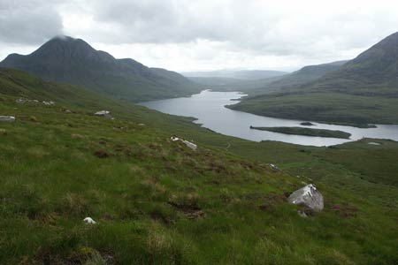
Stac Pollaidh is a small hill by Scottish standards yet it attracts many people than one might imagine. Occupying a solitary position in Assynt in northwest Scotland and with an unmistakable profile it soon becomes evident why this hill is climbed by so many people.
There is small car park (grid ref. NC107095) on the minor road running from the A835 Ullapool to Kylesku road to Lochinver. Cross the road and take the obvious path. You go through a deer fence and continue steeply uphill. Just after the second gate the path divides. Turn left here and still climbing, traverse the wild moorland across the southern face of the hill. The path is well constructed and eventually turns north and then east to reach the northern aspect of Stac Pollaidh.
Continue on the path to join the path coming from the other way and climb again more steeply onto the main ridge of the hill. The views are stupendous with many of the iconic hills of Sutherland including Cul Mor, Suilven, Canisp, and Quinag. If the weather is clear then the panorama will include many more hills in this beautifully wild part of Scotland.
For most people making the ascent onto Stac Pollaidh few will make the true summit. This requires a head for heights and some scrambling skills. Do be careful and do not over estimate your abilities. Despite its modest height this is a serious summit and the most challenging in the area. Despite not making the top you can still enjoy the views which are little different than from the true summit.
My preferred descent is to reverse the outward route and not make the full circular trip. Why? I suppose it is much quieter on the western half of the circuit than what most perceive as the shortest and more direct route at the eastern end of the hill. The descent is very pleasant with beautiful views ahead all the way down to the car park.
Other walks nearby
| Walk 2274 | Cul Mor from Knockan Crag | mod/hard | 8.5 miles |
| Walk 1316 | Falls of Kirkaig | easy | 5.8 miles |
| Walk 1769 | Suilven (North-western approach) | hard | 12.0 miles |
| Walk 1312 | Achmelvich Bay and Alltanabradhan | easy | 3.0 miles |
| Walk 1319 | The Bone Caves of Inchnadamph | easy | 3.0 miles |
| Walk 1018 | Beinn Ghobhlach | moderate | 6.0 miles |
| Walk 3272 | Conival & Ben More Assynt from Inchnadamph | hard | 11.0 miles |
| Walk 1317 | Sail Gharbh (Quinag) | moderate | 5.4 miles |
| Walk 1117 | Glas Bheinn & Eas a' Chual Aluinn (waterfall) | mod/hard | 8.5 miles |
| Walk 1266 | The Old Man of Stoer and the Point of Stoer | easy | 4.5 miles |
Recommended Books & eBooks
Walking in Torridon
 This guidebook contains 52 day walks in Torridon, a remote and much-loved area of the Scottish Highlands. Based around Shieldaig and Slioch, the routes are split into 3 sections: easy walks, long and high level walks and mountain ascents over 2000ft including 9 Munros, and 5 outline suggestions for major ridge walks.
More information
Great Mountain Days in Scotland
 Inspirational guidebook to 50 challenging routes for mountaineers, scramblers, hillwalkers and fell runners, many long enough to backpack over 2 days, especially in winter (12 to 25 miles). A mix of classic routes and unsung gems across Scotland from Galloway to the Outer Hebrides in widely differing wild landscapes. With customised OS mapping.
More information
Messaging & Social Media
Message Walking Britain and follow the latest news.

Mountain Weather
Stay safe on the mountains with detailed weather forecasts - for iOS devices or for Android devices.