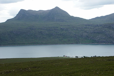
Beinn Ghobhlach from Badrallach
Highland Walk
County/Area - Highland - Central Highland
Author - Lou Johnson
Length - 6.0 miles / 9.8 km Ascent - 2400 feet / 727 metres
Time - 5 hours 20 minutes Grade - moderate
Maps 

| Ordnance Survey Explorer 435 | Sheet Map | 1:25k | BUY |
| Anquet OS Explorer 435 | Digital Map | 1:25k | BUY |
| Ordnance Survey Landranger 19 | Sheet Map | 1:50k | BUY |
| Anquet OS Landranger 19 | Digital Map | 1:50k | BUY |
Walk Route Description
Click image to visit gallery of 9 images.
Rising to 635m Beinn Ghobhlach is a 'Graham' that occupies a stunning position in the peninsula between Loch Broom and Little Loch Broom in north-west Scotland. The start is at the end of the road in the village of Badrallach located on the north shore of Little Loch Broom. Badrallach is reached along a minor road that leaves the A832 a few miles southeast of Dundonnel.
The end of the road in Badrallach (grid ref. NH059918) offers very limited space for parking and you may have to use an alternative space back down the lane. After parking walk west along the well maintained footpath leading to the community of Scoraig, which despite its lack of roads has boomed in recent years. After about a kilometre on the path strike off uphill to the right aiming for the small col just to the east of the 338 spot height on OS maps. There are a few rough tracks used by farmers to gain access to the hills and these do ease the climb.
Reaching the col you get a clear view of the task in hand. Immediately below are Loch na Coireig (on the right) and Loch na h-Uidhe. Behind rise the steep southern slopes of Beinn Ghobhlach. The first task is to head for the strip of land between the two lochs and then tackle the slopes ahead. It can be boggy as you approach the lochs there is nothing that cannot be avoided. Once across the stream linking the two lochs the climb starts in earnest. There is no clear path and it is a case of finding the route that suits you to gain the ridge just to the west of the summit where you are rewarded with a superb 360 degree panorama. It is worth walking past the summit cairn and shelter to the top of the subsidiary summit at the northwestern end of the ridge.
To return to the start, retrace your steps perhaps taking time to explore Loch na h-Uidhe where the outlet stream tumbles over a superb waterfall. However do be aware that there are significant crags either side of the waterfall making a descent a tricky option. It is easiest to return to the strip of land between the lochs and follow your outward path back down to the main lochside path.
Other walks nearby
| Walk 2106 | Ullapool - a Munro Quartet including Beinn Dearg | very hard | 16.0 miles |
| Walk 2529 | Stac Pollaidh Circular | easy/mod | 2.8 miles |
| Walk 1017 | Stac Pollaidh | easy/mod | 3.0 miles |
| Walk 2274 | Cul Mor from Knockan Crag | mod/hard | 8.5 miles |
| Walk 1316 | Falls of Kirkaig | easy | 5.8 miles |
| Walk 1347 | Meall a' Ghiubhais from Kinlochewe | moderate | 8.0 miles |
| Walk 1305 | Sgurr nan Fhir Duibhe from Kinlochewe | hard | 7.5 miles |
| Walk 1769 | Suilven (North-western approach) | hard | 12.0 miles |
| Walk 1319 | The Bone Caves of Inchnadamph | easy | 3.0 miles |
| Walk 1312 | Achmelvich Bay and Alltanabradhan | easy | 3.0 miles |
Recommended Books & eBooks
Skye's Cuillin Ridge Traverse
 This 2-volume set provides all the information required to complete the main ridge traverse on Skye's Black Cuillin. Strategy, gear, training, navigation and logistics are covered, and 10 classic scrambles are described. A lightweight second guidebook gives the scrambler detailed maps, topos and route description for the ridge traverse itself.
More information
Walking the Munros Vol 2 - Northern Highlands and the Cairngorms
 Guidebook to walking the northern Munros, covering the northern Highlands, the Cairngorms and the Isle of Skye. 70 routes are described, including those up Ben Macdui, Braeriach and Cairn Gorm. Routes range from 7 to 46km, requiring a fair level of fitness. The second of two guidebooks to walking Scotland's Munros: peaks higher than 3000ft.
More information
Messaging & Social Media
Message Walking Britain and follow the latest news.

Mountain Weather
Stay safe on the mountains with detailed weather forecasts - for iOS devices or for Android devices.