Kynance Cove, Cadgwith & The Lizard
Cornwall AONB Walk
Region - Cornwall AONB
County/Area - Cornwall
Author - Lou Johnson
Length - 8.0 miles / 13 km Ascent - 1350 feet / 409 metres
Time - 5 hours 20 minutes Grade - moderate
Maps 

| Ordnance Survey Explorer 103 | Sheet Map | 1:25k | BUY |
| Anquet OS Explorer 103 | Digital Map | 1:25k | BUY |
| Ordnance Survey Landranger 203 | Sheet Map | 1:50k | BUY |
| Anquet OS Landranger 203 | Digital Map | 1:50k | BUY |
Walk Route Description
Click image to see photo description.
Lizard Point is the most southerly point on the mainland of Britain. At times it can be very busy with visitors especially when the weather is fine. This Cornwall walk links some of the highlights of the peninsula and provides a good full day walk especially if you take your time and perhaps stop for refreshments en-route. One word of warning - coastal paths never seem as long on maps as they are in reality and the section from Cadgwith back to the Lizard certainly falls into this category with constant twists and turns adding time and miles to the route!
There is a large car park near the Lizard Point and although there are charges this does provide a useful starting point. Alternative parking is available at other points around the route if preferred. From the car park head down to the small cluster of buildings that occupy the southernmost land in Britain and then head west along the coastal footpath.
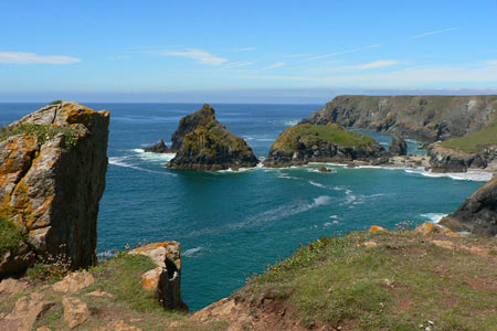
Reaching the first headland the retrospective view is superb with the lighthouse and the rocks of the Lizard summing up the character of this section of coast. The rocks themselves have many tales to tell with shipwrecks a common feature of life in these parts. The path ahead is easy and you can see the rock stacks of Kynance Cove ahead. By now the density of people will have dropped and you can keep up a good pace on the grassy cliff top.
Kynance Cove was particularly popular with the Victorians and they were responsible for naming the rocks. Besides visits from the "masses", many notable and famous people of the period also visited this pretty location including Prince Albert and Tennyson. Their patronage obviously added credibility and helped encourage others to make a visit. It is worth taking a break at Kynance Cove and there is a small cafe which provides a good range of refreshments in season.
The onward path is in a northeasterly direction and can be hard to locate but should present no problems if you are competent at map reading. There is some signage indicating an easy route back to the National Trust car park and this should be followed until the top of the zig-zags. From here take the broad path that heads across Lizard Downs with a broad valley on your left. Stay with this path until you reach the main road.
Cross the road to a track on the opposite side at the left end of the row the of houses. This soon degenerated into a narrow path which leads quite quickly to another road. Turn right and make for the hamlet of Grade where you take the track on the left to the church. With no electricity, this church relies on oil lit lamps and hand pumped bellows for the organ!
Exit the churchyard over a stone stile on the eastern perimeter and follow the path alongside the wall on your left. At the bottom of the field a further path is joined which leads to a road. Cross the road to a white house and follow the lane towards Inglewidden. There are a choice of routes and your are recommended to drop down into the pretty village of Cadgwith (although this can be omitted by walking directly down to the Devil's Frying Pan.
From Cadgwith the return to the Lizard follows the South West Coastal Path and this can be easily located after exploring the village with its small harbour. The first major point of note is the Devil's Frying Pan which is a spectacular natural rock arch below the cliffs. The onward route is straightforward although it can be quite energetic in places. Church Cove is the next major landmark and climbing out of the cove there is a good view back along the coast to Cadgwith. Shortly afterwards you reach the new Lizard Lifeboat station which is spectacularly located.
The coastguards' lookout on Bass Point is the next objective. Just beyond is the white castellated building that was the Lloyds Signal Station. Now a National Trust Property it provided an effective means of passing signals to ships before the electric telegraph was invented. On the next section of path look out for an old bungalow with a bronze plaque. This celebrates the work of Guglielmo Marconi, who used this building for his pioneering experiments on wireless telegraphy. Ahead the lighthouse comes into view and after dropping down into Housel Bay a final climb leads up the cliffs and the car park.
Other walks nearby
| Walk 2010 | Housel Bay & Bass Point from the Lizard | easy | 3.5 miles |
| Walk 2392 | The Lizard Circular | easy/mod | 5.9 miles |
| Walk 1878 | Poldhu Cove to Lizard Point | moderate | 9.5 miles |
| Walk 2001 | Coverack & Lowland Point | easy/mod | 4.2 miles |
| Walk 1778 | Maenporth and Helford Passage Circular | easy/mod | 8.0 miles |
| Walk 2009 | Gillan & Nare Point from Porthallow | easy | 4.7 miles |
| Walk 2007 | Helford Passage & Frenchman's Creek | easy/mod | 7.0 miles |
| Walk 2088 | Rosemullion Head & Mawnan | easy | 4.0 miles |
| Walk 2208 | Marazion - a town stroll | easy | 1.0 miles |
| Walk 3501 | Penzance to Porthcurno via Mousehole and Lamorna | moderate | 11.0 miles |
Recommended Books & eBooks
South West Coast Path Map Booklet - St Ives to Plymouth
 Map of part of the southern section of the 630 mile (1014km) South West Coast Path National Trail. Covers the trail from St Ives to Plymouth along the west Cornwall and Devon coastline. This convenient and compact booklet of Ordnance Survey 1:25,000 maps shows the route, providing all of the mapping you need to walk the trail in either direction.
More information
The South West Coast Path
 Guidebook to walking the entire South West Coast Path National Trail. The route runs for 630 miles from Minehead to Poole along the north Devon, Cornish, south Devon and Dorset coastline. Divided into 45 stages, this long-distance coastal trek could be completed within 4 weeks, or walked in sections. Guide includes maps and essential information.
More information
Messaging & Social Media
Message Walking Britain and follow the latest news.

Mountain Weather
Stay safe on the mountains with detailed weather forecasts - for iOS devices or for Android devices.