Swinner Gill and Muker from Thwaite
Yorkshire Dales Walk
Nat Park - Yorkshire Dales - Swaledale
County/Area - North Yorkshire
Author - Lou Johnson
Length - 8.5 miles / 13.8 km Ascent - 1975 feet / 598 metres
Time - 6 hours 10 minutes Grade - mod/hard
Maps 

| Ordnance Survey Explorer OL30 | Sheet Map | 1:25k | BUY |
| Anquet OS Explorer OL30 | Digital Map | 1:25k | BUY |
| Ordnance Survey Landranger 98 | Sheet Map | 1:50k | BUY |
| Anquet OS Landranger 98 | Digital Map | 1:50k | BUY |
Walk Route Description
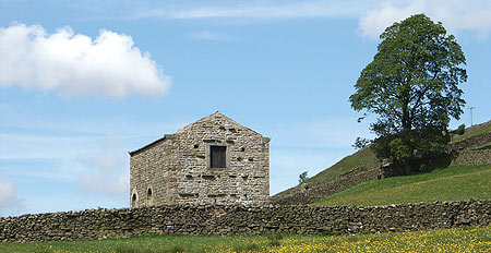
Click image to see photo description.
This Yorkshire Dales walk is rather more energetic than it might appear when looking at a map. The start is the pleasant Dales village of Thwaite with visits to two other communities in Swaledale, Keld and Muker. The route contains sections of the Pennine Way and Coast to Coast National Trails.
The start if the small village of Thwaite. I parked in the lay-by on the south side of the river on the approach road (Grid ref. SD 891981) from Muker. Wherever you park do be considerate for the needs of the local community. After parking walk into the centre of the village and turn right following the Pennine Way signs for Keld. After crossing a few meadows the path starts to climb onto the flank of Kisdon Hill. The signage is clear and ignoring all other paths stay with the Pennine Way as it turns north and runs parallel to the River Swale, which is now some 400n feet below you on your right.
The views are impressive and with the aid of your map you should be able to pick out the return route on the other side of the valley. Continuing on the Pennine Way the path descends slowly towards the village of Keld veering northwest as the village gets nearer. Far below, on your right, as you pass through woodland is Kisdon Force, which in spate is worth a detour. However on all my visits to the area the water level has been low and the waterfalls disappointing.
Reaching a path junction (Grid ref. SD 894010) you have the option of continuing into the village of Keld where there are limited opportunities for refreshments and public toilets. If you do not want to visit the village, turn right at this junction and cross the River Swale. On reaching the other side, leave the Pennine Way and turn right. You are now on the Coast to Coast National Trail.
The path climbs a little to reach a junction (Grid ref. SD 904008). Bear left here and continue past the ruins of Crackpot Hall to enter the gorge containing Swinner Gill with ample evidence of the former extensive lead mining operations. Follow the gill upstream to grid ref. SD 912012 where you cross the stream and turn south along a high level path. This followed across the side of Black Hill with excellent views of Swaledale.
Reaching Arn Gill (Grid ref. SD 912992) descend the path on the south side of this stream for a short way before turning left along a path that more or less contours the hillside into woodland. This path drops further to reach a track (Grid ref. SD 911985). Turn right here and drop down to the footbridge over the River Swale (Grid ref. SD 910986). Cross the bridge and in a few yards turn left onto the flagged path to Muker. Crossing a number of meadows you reach the village. Muker has a cafe, pub, toilets and shop and provides a good place to spend some time.
Exit Muker on the path at the western end of the village that leads to Usha Gap Bridge (Grid ref. SD 900979). After a short section along the road a further path leads off right to cross fields and lead you back to Thwaite.
Other walks nearby
| Walk 1340 | Muker & Upper Swaledale from Keld | easy/mod | 6.5 miles |
| Walk 1056 | Gunnerside & Surrender Bridge | moderate | 10.3 miles |
| Walk 1197 | Gunnerside & Swinner Gills | moderate | 8.5 miles |
| Walk 3093 | Bunton Hush, Blakethwaite & Gunnerside Gill | easy/mod | 5.5 miles |
| Walk 3624 | Great Shunner Fell from Hardraw | mod/hard | 9.2 miles |
| Walk 3621 | Great Shunner Fell & Lovely Seat | mod/hard | 11.4 miles |
| Walk 1341 | Nine Standards Rigg | moderate | 6.0 miles |
| Walk 2155 | Mossdale & Cotterdale | easy/mod | 7.9 miles |
| Walk 2273 | Dodd Fell Hill & Drumaldrace | moderate | 11.5 miles |
| Walk 2286 | Gayle & Aysgill Force from Hawes | easy | 3.5 miles |
Recommended Books & eBooks
Walking in the Yorkshire Dales: South and West
 Part of a two-book set, this guidebook describes 44 walks in the southern and western Yorkshire Dales, including the famous 23 mile Three Peaks circuit over Pen-y-Ghent, Whernside and Ingleborough. The other, mostly circular routes of 3½ to 13 miles cover the scenic region between Sedbergh, Kirkby Lonsdale, Settle, Skipton and Grassington.
More information
Pennine Way Map Booklet
 Map of the 270 miles (435km) Pennine Way National Trail, between Edale in the Peak District and Kirk Yetholm in the Scottish Borders. This booklet is included with the Cicerone guidebook to the trail, and shows the full route on Ordnance Survey 1:25,000 maps. This popular long-distance route typically takes three weeks to complete.
More information
Messaging & Social Media
Message Walking Britain and follow the latest news.

Mountain Weather
Stay safe on the mountains with detailed weather forecasts - for iOS devices or for Android devices.