Gunnerside & Surrender Bridge
Yorkshire Dales Walk
Nat Park - Yorkshire Dales - Swaledale
County/Area - North Yorkshire
Author - Lou Johnson
Length - 10.3 miles / 16.7 km Ascent - 1500 feet / 455 metres
Time - 6 hours 40 minutes Grade - moderate
Maps 

| Ordnance Survey Explorer OL30 | Sheet Map | 1:25k | BUY |
| Anquet OS Explorer OL30 | Digital Map | 1:25k | BUY |
| Ordnance Survey Landranger 92 | Sheet Map | 1:50k | BUY |
| Anquet OS Landranger 92 | Digital Map | 1:50k | BUY |
| Ordnance Survey Landranger 98 | Sheet Map | 1:50k | BUY |
| Anquet OS Landranger 98 | Digital Map | 1:50k | BUY |
Walk Route Description
Click image to visit gallery of 4 images.
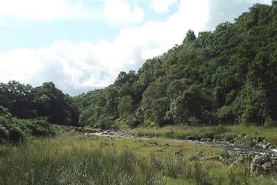
This varied and energetic Yorkshire Dales walk is full of interest and shares part of its route with Walk 1197. It is a varied expedition and includes woodland, open moor and considerable interesting remains of the once vibrant lead mining industry. The walk starts in the attractive village of Gunnerside and on most days there is ample parking in the village square (grid ref. SD 950982) or on the verges of the main road that heads west to Muker.
After parking cross the bridge over Gunnerside Gill in the centre of the village and take the footpath heading north along its east bank. There are a few sections where the path leaves the river bank but in general it stays close all the way upstream to Blakethwaite Lead Mine. The first section is through pleasant woodland but the views open up as you reach open valley. The surroundings become wilder and more interesting and you reach the first significant mine ruins of the walk - Bunton Mine (grid ref. SD939012). On both sides of the valley are the substantial "hushes" where miners washed away the soil to expose the valuable veins of lead. Despite the demise of mining nearly a century ago the scars still remain.
After passing Bunton Mine you reach a four-way finger post (grid ref. SD939012). Continue ahead on the rising path signed to "Blakethwaite Dam". The path soon drops down to the valley floor to pass Blakethwaite Smelt Mill (grid ref. SD 936017) on the other side of Gunnerside Gill. Do not be misled into thinking you have reached Blakethwaite Lead Mines as these are about another kilometre upstream (grid ref. SD 938028) and form the next objective on our route. From here a path leads up onto the flank of Friarfold Moor. (This path can be hard to locate if you are not too sure exactly where you are and if this is the case it might be better to retrace your steps to Bunton Hush and follow the signed footpath to Surrender Bridge).
The climb onto the moor is short and you soon join a track that heads south and then east through significant old mine workings to reach Level House Bridge (grid ref. SD 964013). Turn south-east alongside Hard Level Gill to pass the more complete ruins of Old Gang Smelting mills to reach Surrender Bridge in a further mile or so. Turn right onto the road, cross the bridge and stay with the road for approximately 400 metres. Take the signed path on your right that leads across Feetham Pasture to the small hamlet of Blades.
Going past the cottages you reach a tarmacked road. Turn right and follow it west. It degenerates into a track before continuing as a footpath climbing gently with some great views into Swaledale far below. The onward route is quite straightforward across open pasture. Reaching a wall (grid ref. SD 963983) fork left to leave the main path, which contours across the hillside, and descend quite steeply down a field. This leads to a rough track that drops down into Gunnerside village to complete the walk.
Other walks nearby
| Walk 1252 | Great Pinseat | easy/mod | 5.5 miles |
| Walk 1053 | Swinner Gill and Muker | mod/hard | 8.5 miles |
| Walk 1340 | Muker & Upper Swaledale from Keld | easy/mod | 6.5 miles |
| Walk 2190 | Calver Hill & Reeth Low Moor | easy/mod | 6.0 miles |
| Walk 1253 | Booze & Slei Gill from Langthwaite | easy | 2.5 miles |
| Walk 3478 | Cringley Hill & Scar House from Langthwaite | easy/mod | 4.8 miles |
| Walk 1694 | Nappa Hall & Whitfield Gill Force | easy/mod | 6.0 miles |
| Walk 2822 | Aysgarth & Castle Bolton | mod/hard | 14.5 miles |
| Walk 3524 | Semer Water and Cam High Road from Bainbridge | easy/mod | 5.7 miles |
| Walk 1768 | Thomas Gill and Ravenseat from Tan Hill | moderate | 8.7 miles |
Recommended Books & eBooks
Walking in the Yorkshire Dales: North and East
 This guidebook contains 43 circular day walks in the north and east Yorkshire Dales. It explores the dales, hills and moors between Kirkby Stephen and Pateley Bridge. Walking ranges from gentle 3 mile strolls to more strenuous day-long rambles across the Howgills, Wensleydale, Swaledale, Nidderdale, Mallerstang and Coverdale.
More information
Walking in the Yorkshire Dales: South and West
 Part of a two-book set, this guidebook describes 44 walks in the southern and western Yorkshire Dales, including the famous 23 mile Three Peaks circuit over Pen-y-Ghent, Whernside and Ingleborough. The other, mostly circular routes of 3½ to 13 miles cover the scenic region between Sedbergh, Kirkby Lonsdale, Settle, Skipton and Grassington.
More information
Messaging & Social Media
Message Walking Britain and follow the latest news.

Mountain Weather
Stay safe on the mountains with detailed weather forecasts - for iOS devices or for Android devices.