Newquay to Porthcothan coast path
Cornwall AONB Walk
Region - Cornwall AONB
County/Area - Cornwall
Author - Paul Deane
Length - 10.5 miles / 17.1 km Ascent - 2500 feet / 758 metres
Time - 7 hours 50 minutes Grade - moderate
Maps 

| Ordnance Survey Explorer 106 | Sheet Map | 1:25k | BUY |
| Anquet OS Explorer 106 | Digital Map | 1:25k | BUY |
| Ordnance Survey Landranger 200 | Sheet Map | 1:50k | BUY |
| Anquet OS Landranger 200 | Digital Map | 1:50k | BUY |
Walk Route Description
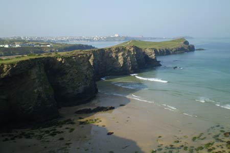
Click image to visit gallery of 5 images.
This linear Cornwall walk starts from Newquay and follows the South West Coast Path north to Porthcothan. The walking is superb and quite strenuous with constant views of this dramatic coastline. If you are lucky you will see a wide variety of marine wildlife including seals and many species of birds.
The starting point for this walk is a car park, not marked on the map, by Newquay railway station at grid ref. SW 815617. Walk out of the car park to the road, cross over and turn right. Continue along the road for approximately 1/4 mile until you see a grassed area on your left. Walk through the entry and follow the path as it winds around the cliff tops overlooking Tolcarne Beach. At the far end of the grassed area you will meet a residential road. Turn left onto the road and pass the car park (again not marked), a hotel and 'newish' houses. The road ends and the path crosses another grassed area and drops down to the low cliff tops overlooking Porth Beach.
Follow the path to the road. Turn left and join the main Padstow road after a few hundred yards. Before you join the main road it is possible to walk across the beach. The sand here is loose and quite hard going so it is probably easier to stay on the road. The road and beach routes join at a road bridge over a stream. Cross this and leave the road 200yds further on by an ice cream kiosk.
The path makes a diversion out west above the beach towards Porth Island where there are some impressive pre-historic defensive earthworks and the remains of a settlement. Pass the footbridge that leads to the Island and head back east along the cliffs towards the road. The path turns left and swings away from the road and you are finally away from 'civilisation' and on the coast path proper.
There is a gentle climb with Watergate Beach down to your left. The path hugs the cliffs before dropping steeply into Watergate Bay. Join the road and keep left past the car park, new outdoor pursuits complex and hotel then climb the steep road before you join the path again to your left after a short distance. Again the path passes between fields and cliff tops before you see Beacon Cove. This presents a truly impressive piece of coastal erosion. The hill, called the Beacon, has a huge 'horse-shoe' missing form it and looks like something from Snowdonia (Eryri). Skirt around the Cove and out to Berryl's Point.
Next swing east again and drop steeply into Mawgan Porth with its extraordinarily ugly hotel. Join the road briefly and then there's a short slog over the loose sand of Mawgan Porth beach before climbing the steep path up the cliff on the other side. The path rounds Trenance Point and Trerathic Point, passes Carnewas Island and then crosses over the awe inspiring cliffs, islands and stacks of Bedruthan Steps. I found myself taking photograph after photograph but found it impossible to capture and encompass a sense of the scale of this place in any single frame.
Follow the path northwards over the dizzying heights and round to Pentire Steps. Lots of little notices give good advice about the cliffs - it is rather important, apparently, not to fall over any of them. Next the path crosses some open-access heathland and then drops down to Porth Mear. When the tide is out Porth Mear resents a huge jumble of rocks with Trescore Islands forming a backdrop to a really lovely view. Follow the path around to the east and arrive amongst the houses of Porthcothan overlooking the lovely beach. There is a café and beyond that the road with the car park (Grid ref. SW858719) marking the end of the walk, on the other side.
Other walks nearby
| Walk 1547 | Trevose Head & Constantine Bay from Porthcothan | easy/mod | 8.5 miles |
| Walk 1961 | Porthcothan to Watergate Bay | easy/mod | 6.8 miles |
| Walk 3589 | Padstow from Little Petherick | easy | 5.0 miles |
| Walk 3738 | Polzeath & Pentire Point from Rock | moderate | 11.4 miles |
| Walk 2294 | St. Agnes to Porthtowan | easy/mod | 5.0 miles |
| Walk 2003 | Cowlands, Coombe & Roundwood Quay from Trelissick | easy/mod | 9.0 miles |
| Walk 2462 | The Rumps & Pentire Point | easy/mod | 4.0 miles |
| Walk 1027 | Nare Head & Portloe | moderate | 7.0 miles |
| Walk 3264 | Port Quin & Port Isaac Circular | easy/mod | 5.7 miles |
| Walk 1033 | Dodman Point & Gorran Haven | mod/hard | 11.0 miles |
Recommended Books & eBooks
Walking in Cornwall
 This guidebook includes routes to 40 day walks in Cornwall. From short, easy strolls to longer, wilder routes, there is plenty to appeal to both families and experienced walkers. The walks explore the interior and coasts, including walks through picturesque villages, old tin-mining areas and the Lizard and Land's End Peninsulas.
More information
Messaging & Social Media
Message Walking Britain and follow the latest news.

Mountain Weather
Stay safe on the mountains with detailed weather forecasts - for iOS devices or for Android devices.