Angletarn Pikes from Hartsop
Lake District Walk
Nat Park - Lake District - Lake District Far Eastern Fells
Wainwrights - Angletarn Pikes
County/Area - Cumbria
Author - Lou Johnson
Length - 7.0 miles / 11.4 km Ascent - 1810 feet / 548 metres
Time - 5 hours 20 minutes Grade - moderate
Maps 

| Ordnance Survey Explorer OL5 | Sheet Map | 1:25k | BUY |
| Anquet OS Explorer OL5 | Digital Map | 1:25k | BUY |
| Ordnance Survey Landranger 90 | Sheet Map | 1:50k | BUY |
| Anquet OS Landranger 90 | Digital Map | 1:50k | BUY |
Walk Route Description
Click image to see photo description.
This is a popular Lake District circular walk offering some excellent scenery and pleasant walking. After parking in the small car park at Cow Bridge (Grid ref. NY403134) on the A592 between Patterdale and Kirkstone Pass, follow the main road back towards the village of Hartsop turning left into the lane and left again into a farm access road. This leads straightforwardly to Dubhow where a path rises across the fellside to Boredale Hause.
The Hause is a great place to rest and take in the view. Despite the relatively low altitude the panorama is extensive especially if you take a few minutes to seek out the views. Turning south a well used path heads towards the Angletarn Pikes, which always seem prominent when viewed from the valley floor. There is a choice of paths and we kept to the highest taking the time to clamber to the both the north and south summits of the Angletarn Pikes.
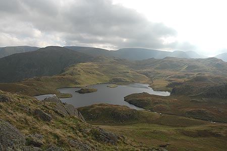
The extra height gained since Boredale Hause has considerably improved the view and the High Street range dominates the view south. Across the valley to the west, the high peaks of the Helvellyn Massif form an impressive line of mountains. Heading around the north and eastern shores of Angletarn, beautifully located amidst the mountains, you are treated with an excellent view down into Martindale from the lofty viewpoint of Satura Crag.
At times the path is soft although do not let this deter you as you continue towards the Knott. Reaching a cross wall (grid ref. NY433131), turn south west down the hillside to the small footbridge across the outlet from Hayeswater. This small reservoir is dramatically located in a deep u-shaped valley with High Street providing a grand backdrop. Turning north east keep to the south side of Hayeswater Gill as its tumbles prettily down to the village of Hartsop.
Roughly half way to the village cross to the northern side of the Gill and follow the improving track downhill. The village of Hartsop has some interesting cottages and some still have their spinning galleries, a feature common on many Lakeland cottages. Within minutes you are back at your car after having enjoyed some fine mountain walking without too much hard work!
Other walks nearby
| Walk 3309 | Hartsop, Hartsop Dodd, Stony Cove Pike & Kirkstone Pass | moderate | 8.5 miles |
| Walk 1228 | Thornthwaite Beacon & High Street | moderate | 6.5 miles |
| Walk 1959 | Gray Crag and Pasture Beck from Hartsop | moderate | 5.5 miles |
| Walk 2585 | Hartsop Dodd, Stony Cove Pike, High St. & The Knott | mod/hard | 10.0 miles |
| Walk 1230 | Birks & Arnison Crag | moderate | 5.5 miles |
| Walk 1520 | Helvellyn & Fairfield Horseshoe from Patterdale | very hard | 13.0 miles |
| Walk 2047 | Place Fell from Patterdale | moderate | 7.5 miles |
| Walk 2425 | Boredale Circular from Patterdale | mod/hard | 11.5 miles |
| Walk 3670 | Angle Tarn and Hayeswater | moderate | 8.3 miles |
| Walk 1156 | Helvellyn via Striding Edge | hard | 9.5 miles |
Recommended Books & eBooks
Lake District: Low Level and Lake Walks
 This guidebook describes 30 of the best low-level walks in the Lake District. From delightful wooded glades and sparkling tarns, to waterfalls and glacier-carved valleys towered over by craggy mountains. The walks described aim to seek out the best walking that the lower areas of the Lake District have to offer.
More information
Walking the Lake District Fells - Langdale
 Part of the Walking the Lake District Fells series, this guidebook covers a wide range of routes to 25 Lakeland summits that can be climbed from the Great Langdale valley, Ambleside and Grasmere, with highlights including Scafell Pike, Bowfell, the Langdale Pikes and Helm Crag (the Lion and the Lamb). Includes suggestions for longer ridge routes.
More information
Messaging & Social Media
Message Walking Britain and follow the latest news.

Mountain Weather
Stay safe on the mountains with detailed weather forecasts - for iOS devices or for Android devices.