Goatfell, Isle of Arran
North Ayrshire Walk
County/Area - North Ayrshire
Author - John Turner
Length - 9.0 miles / 14.6 km Ascent - 3200 feet / 970 metres
Time - 7 hours 40 minutes Grade - mod/hard
Maps 

| Ordnance Survey Explorer 361 | Sheet Map | 1:25k | BUY |
| Anquet OS Explorer 361 | Digital Map | 1:25k | BUY |
| Ordnance Survey Landranger 69 | Sheet Map | 1:50k | BUY |
| Anquet OS Landranger 69 | Digital Map | 1:50k | BUY |
Walk Route Description
Click image to visit gallery of 6 images.
This Isle of Arran route approaches Goatfell from Glen Sannox and then continues via the Saddle onto North Goatfell. The walk continues to Goatfell's summit from where a quiet return to the coast road is made following Corrie Burn eastwards. The route does involve some scrambling and skills in navigation are required.
The start is Either of 2 lay-bys (grid ref NS016453). Access Glen Sannox via the track and gates on opposite side of road about 30m north. If using two cars, last 3 km road walk can be avoided by leaving a car at High Corrie (grid ref. NS025433). I recommend that the route should be done as described and not reversed, this is to allow the main tricky scrambling parts of the walk to be ascended, as down climbing them could pose problems.
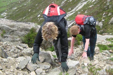
The longish walk into Glen Sannox allows gradual height gain on a good path. We saw several groups of deer higher up the slopes. The path mainly follows the north side of Sannox Burn, crossing over at grid ref. NR981434 before quickly gaining height up The Saddle. Good views of the impressive cliffs of Cir Mhor might make you smug that you are not going that way, but there are a couple of tricky steps and a chimney scramble that cannot be avoided - so you will get some 'hands on' action (see photo of main scramble).
Once The Saddle is reached, views open up down Glen Rosa and back down Glen Sannox. The ridge on the opposite side of Glen Sannox including Portcullis Buttress and Ceum na Caillich (Witch's Step) being particularly impressive. The route up from The Saddle to North Goatfell also calls for some route-finding, many alternative paths lead to steep and tricky parts, staying on the high route offers the easiest ascent option. There is no actual summit cairn or feature to signal your arrival at North Goat fell (818m). You know you're at the top when you scramble up the bouldery rocks and can't go any higher.
The views from here open up to the east now, and a path system around the base of crags, avoiding the more difficult route heads along the eastern side of Stocach Ridge. When Goat fell (874m) was reached we entered a new world, we had only seen a couple of people on our route so far that day and to suddenly be among about a dozen to fifteen or so other people was a bewildering experience. Most had ascended from Brodick or Glen Rosa via the "Tourist Route" and some had obviously taken the term 'tourist route' literally, by appearing to be a little inappropriately dressed and equipped.
The descent we used was down the Meall Breac Ridge, which gave stunning views across the Firth of Clyde areas all the way up Loch Fyne. The path forks at grid ref. NR981434. Don't head south towards Brodick (everyone else did), continue to descend easterly eventually dropping down northerly into Coire L'an and follow the Corrie Burn easterly down an obvious path to High Corrie. The final 3 km is a road walk back to the start point, this can be avoided by using a second car or using the infrequent bus service back to Sannox.
Other walks nearby
| Walk 2367 | Kaim Hill & Fairlie Glen | moderate | 3.5 miles |
| Walk 2347 | Duncryne from Gartocharn | easy | 2.0 miles |
| Walk 1296 | Beinn Eich & Doune Hill | mod/hard | 8.0 miles |
| Walk 2659 | Conic Hill | easy/mod | 4.0 miles |
| Walk 2552 | West Highland Way Experience | moderate | 95.0 miles |
| Walk 1490 | West Highland Way - A personal experience | moderate | 96.0 miles |
| Walk 1491 | WHW - Day 1 - Milngavie to Drymen | moderate | 12.0 miles |
| Walk 1492 | WHW - Day 2 - Dryden to Rowardennan | moderate | 15.0 miles |
| Walk 3009 | Ben Lomond | mod/hard | 7.5 miles |
| Walk 1493 | WHW - Day 3 - Rowardennan to Inverarnan | moderate | 14.0 miles |
Recommended Books & eBooks
No suggestions for this area.Messaging & Social Media
Message Walking Britain and follow the latest news.

Mountain Weather
Stay safe on the mountains with detailed weather forecasts - for iOS devices or for Android devices.