Grains in the Water & Alport Castles from Snake Pass
Peak District Walk
Nat Park - Peak District - Bleaklow Longendale
County/Area - Derbyshire
Author - Lou Johnson
Length - 12.0 miles / 19.5 km Ascent - 1875 feet / 568 metres
Time - 7 hours 50 minutes Grade - mod/hard
Maps 

| Ordnance Survey Explorer OL1 | Sheet Map | 1:25k | BUY |
| Anquet OS Explorer OL1 | Digital Map | 1:25k | BUY |
| Ordnance Survey Landranger 110 | Sheet Map | 1:50k | BUY |
| Anquet OS Landranger 110 | Digital Map | 1:50k | BUY |
Walk Route Description
Click image to visit gallery of 3 images.
This is a great Peak District walk exploring the beautiful moors and valleys to the south of Bleaklow Head. Like many walks in this area enjoyment is dependant on good weather. Ideally complete this route after a spell of dry weather or after a heavy frost. This makes the going underfoot far more pleasant. If your map and compass skills are lacking then choose a day when visibility is good with little likelihood of low cloud. The area between Hern Clough and Grains in the Water is especially confusing in mist and is a key to successful completion of the walk.
The walk begins from the car park adjacent to the A57 Snake Pass Road at Birchen Clough Bridge (Grid ref. SK109914). This is approximately one kilometre west of the Snake Inn. Cross the road and descend into the wood on the opposite side to the car park. Turn right along the path at the bottom and follow Lady Clough north. Shortly after leaving the wood the path exits onto the A57. This needs to be followed in the direction of Glossop for a short way until you can leave the main road by a signed path that heads northwest following the old Roman road towards Doctor's Gate.
Reaching the Pennine Way at a "cross roads" turn right and follow the paved path as it heads north-east across the moor with Devil's Dyke to your immediate right. The path climbs a little to reach Alport Low where it swings north. It is hard to precisely describe where you leave the Pennine Way but locating Hern Clough (Grid ref. SK098947) is the key to the onward route. Once you are sure turn right off the Pennine Way and descend to Grains in the Water using a mixture of paths and sheep trods.
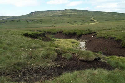
Despite its reputation Bleaklow has some delightful spots and Grains in the Water ranks amongst the best. Seeing few people, you are left alone to enjoy the moorland with grouse and larks providing the only interruption to silence. The next section of the route is wonderful, following the infant River Alport as it heads down a dramatic valley.
Once you leave Grains in the Water the route follows clear paths for most of the way and there is little risk of you losing your way. However there are some boggy sections to contend with especially after heavy rain although the views more than compensate for wet boots! The river twists and turns losing height faster than the path, which stays on its northern side. The going is fast as you stay on the plateau with Alport Dale and its river eventually over five hundred feet below you on your right hand side.
Despite the distance Alport Castles is soon reached. This massive landslip is quite spectacular with a large section of the edge severed from the main bulk of the plateau. Continue past the Castles following the wall. Turn right (Grid ref. SK145912) to leave the ridge and descend to Alport Castles Farm and Alport Farm down a clear path. Reaching the second farm turn left along the farm access road and stay with this for over a kilometre to reach Hayridge Farm.
From Hayridge Farm a clear well-signed path follows the route of the old Roman Road to lead you back to the start. This section always seems a long way with a steady climb (not welcome at the end of a day) across the flanks of Cowms Moor to enter Oyster Clough. From here the route at first skirts a wood before entering it on the final stage down to the A57. Reaching the main road turn right and you are back at the start in a few minutes.
Other walks nearby
| Walk 1489 | Blackden Brook, Kinder & Upper Ashop | moderate | 6.8 miles |
| Walk 3049 | Bleaklow Stones from Derwent Valley | mod/hard | 12.0 miles |
| Walk 1159 | Grindsbrook & Edale Head | moderate | 7.5 miles |
| Walk 1264 | Rushup Edge & Crowden Tower | moderate | 10.0 miles |
| Walk 1295 | Ringing Roger & Edale Cross | moderate | 10.0 miles |
| Walk 2595 | Castleton Great Ridge from Edale | moderate | 8.5 miles |
| Walk 2615 | The Kinder Edges | mod/hard | 18.0 miles |
| Walk 3350 | Kinder Scout Summit | moderate | 8.5 miles |
| Walk 1113 | Ringing Roger & Grindslow Knoll | moderate | 5.5 miles |
| Walk 1300 | Hope Cross & Ringing Roger | moderate | 8.0 miles |
Recommended Books & eBooks
Pennine Way Map Booklet
 Map of the 270 miles (435km) Pennine Way National Trail, between Edale in the Peak District and Kirk Yetholm in the Scottish Borders. This booklet is included with the Cicerone guidebook to the trail, and shows the full route on Ordnance Survey 1:25,000 maps. This popular long-distance route typically takes three weeks to complete.
More information
Walking in the Peak District - White Peak East
 Guidebook describing 42 half-day and day walks in the limestone landscapes of Derbyshire's White Peak, part of the Peak District National Park. One of two volumes, this book covers the east of the region, with potential bases including Bakewell, Eyam, Castleton, Birchover, Matlock and Wirksworth.
More information
Messaging & Social Media
Message Walking Britain and follow the latest news.

Mountain Weather
Stay safe on the mountains with detailed weather forecasts - for iOS devices or for Android devices.