Cnicht from Croesor
Snowdonia/Eryri Walk
Nat Park - Snowdonia - Moelwyns Moel Siabod Cnicht
County/Area - Gwynedd
Author - Lou Johnson
Length - 6.3 miles / 10.2 km Ascent - 1700 feet / 515 metres
Time - 4 hours 50 minutes Grade - moderate
Maps 

| Ordnance Survey Explorer OL17 | Sheet Map | 1:25k | BUY |
| Anquet OS Explorer OL17 | Digital Map | 1:25k | BUY |
| Ordnance Survey Explorer OL18 | Sheet Map | 1:25k | BUY |
| Anquet OS Explorer OL18 | Digital Map | 1:25k | BUY |
| Ordnance Survey Landranger 115 | Sheet Map | 1:50k | BUY |
| Anquet OS Landranger 115 | Digital Map | 1:50k | BUY |
| Ordnance Survey Landranger 124 | Sheet Map | 1:50k | BUY |
| Anquet OS Landranger 124 | Digital Map | 1:50k | BUY |
Walk Route Description
Click image to see photo description.
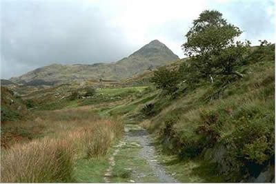
The village of Croesor is quietly situated in a fine valley which is walked on the return leg of this fine walk. Once an area humming with activity, the slate quarries have long since closed and the valley has returned to a quieter life. Cnicht has a distinct but misleading image. From the main roads to the south west the mountain has a distinctive shape - pointed with sheer faces on either flank - and nicknamed the "Welsh Matterhorn". In reality the summit of Cnicht is the end of fine ridge and its pyramidal shape is in fact a cross section of the mountain.
There is a small car park in Croesor (grid ref. SH 631446) with ample space for most days. To start this Snowdonia (Eryri) walk, leave the village by taking the lane up past the school and chapel. At a gate continue northwards to the brow of the hill where you fork right. The way ahead is now obvious as you aim for the summit climbing gently at first with fine views over the surrounding countryside. The way steepens and there are a couple of short scrambles before you reach the summit (2260 ft. / 689 m.) which is a fine viewpoint with almost a 360 degree panorama of mountains.
The next objective is the southern shore of llyn yr Adar, backed by the Ysgafell Wen range of mountains. This is wild country and the walkers relatively few and you have ample time to enjoy the peace and quiet. A path, in places very sketchy, leads south east towards Cwm Corsiog. Before reaching this llyn turn west choosing the easiest route down to Llyn Cwm-y-foel in the valley. There are no unseen crags but it is still easier to follow one of the small streams that tumble down the mountainside.
On reaching Llyn Cwm-y-foel follow the south shore to the dam. Cross to the north side of the outlet and pick up the distinct path that gentle descends across the hillside and into the valley. This descent is very pleasant and allows you to examine in detail the wonderful valley of Cwm Croesor before you join the track back into the village.
Other walks nearby
| Walk 3058 | Llyn yr Adar & Llyn Edno from near Bethania | moderate | 9.0 miles |
| Walk 1427 | Craflwyn circular from near Beddgelert | easy/mod | 2.5 miles |
| Walk 2150 | Llyn Dinas and Cwm Bychan from Beddgelert | easy/mod | 6.0 miles |
| Walk 2560 | Moel Hebog, Moel yr Ogof & Moel Lefn from Beddgelert | mod/hard | 6.5 miles |
| Walk 1799 | Moel Hebog | moderate | 5.5 miles |
| Walk 1988 | Beddgelert, Moel Hebog, Meol yr Ogof & Moel Lefn | mod/hard | 6.8 miles |
| Walk 3074 | Mynydd Sygun | moderate | 4.5 miles |
| Walk 3231 | Moel Hebog, Meol yr Ogof and Moel Lefn from Beddgelert | mod/hard | 6.8 miles |
| Walk 1426 | Aberglaslyn and Cwm Bychan | easy/mod | 5.8 miles |
| Walk 1334 | Cnicht from Tanygrisiau | moderate | 8.0 miles |
Recommended Books & eBooks
Snowdonia: 30 Low-level and easy walks - North
 Guidebook describing 30 walks in Snowdonia, Wales. Routes are mostly low level and on clear paths and showcase the region's beautiful scenery and rich history and culture. Part of a 2-volume set, this northern volume includes the Snowdon area, the Ogwen and Conwy Valleys, Betws-y-Coed, Beddgelert, Ffestiniog and the coast.
More information
Great Mountain Days in Snowdonia
 Inspirational guidebook to 40 great mountain day walks and scrambles in Snowdonia. Inspirational routes for all abilities across the National Park with routes up Snowdon and Moel Eilio, the Glyderau, the Carneddau, Eifionydd, Siabod and the Moelwynion, Rhinogydd (the Harlech Dome), Migneint and the Arans and Cadair Idris and the Tarrens.
More information
Messaging & Social Media
Message Walking Britain and follow the latest news.

Mountain Weather
Stay safe on the mountains with detailed weather forecasts - for iOS devices or for Android devices.