The High Stile Ridge from Buttermere
Lake District Walk
Nat Park - Lake District - Lake District Western Fells
Wainwrights - High Crag, High Stile, Red Pike (Buttermere)
County/Area - Cumbria
Author - Lou Johnson
Length - 10.0 miles / 16.3 km Ascent - 2650 feet / 803 metres
Time - 7 hours 40 minutes Grade - hard
Maps 

| Ordnance Survey Explorer OL4 | Sheet Map | 1:25k | BUY |
| Anquet OS Explorer OL4 | Digital Map | 1:25k | BUY |
| Ordnance Survey Landranger 90 | Sheet Map | 1:50k | BUY |
| Anquet OS Landranger 90 | Digital Map | 1:50k | BUY |
Walk Route Description
Click image to visit gallery of 6 images.
Ridge walking is wonderful - after gaining the first summit the going is easy and further peaks can be added without too much effort. That's the theory. Now let's put it to the test on one of the Lake District's great ridge walks. From the shores of Buttermere the delights of the High Stile Ridge are not completely apparent as the shoulders of High Stile do limit the view of the ridge itself and this walk gradually uncovers the wonders of this lofty trio of mountains.
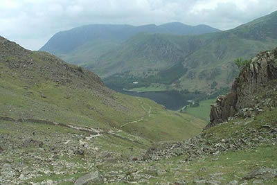
We parked at Gatescarth Farm (grid ref. NY194149) at the foot of the Honister Pass and overlooked by Fleetwith Pike. There is a small charge, which I feel hill-farmers can justify in their world of low income. The first section of the walk takes you to Peggy's Bridge at the southern end of Buttermere. From here you climb to Scarth Gap amidst ever improving rock scenery. For most of the way up to the Gap you have good views of Fleetwith Pike and Haystacks (Wainwright's favourite fell). On reaching the col, the number of mountains on view increase dramatically with Great Gable and Pillar two of the notable giants now attracting your gaze.
Turning north west from the Gap, you are soon on top of Seat. A small subsidiary top, it's a fine place to have a rest before the last major ascent of the day to the summit of High Crag. From Seat the steep climb up Gamlin End looks hard. However grim it may have been, the struggle up scree has been replaced with a wonderful paved path, which soon has you alongside the summit cairn on High Crag admiring the views.
Ahead lies the ridge to High Stile with the rocky amphitheatre of Burtness Comb to your right. The effort expended in getting this far is soon forgotten as you stride along the ridge admiring the scenery. All around are examples of the best that Lakeland can offer, that unique blend of mountain and lake. All too soon you have reached High Stile, where a short walk out to the north-easterly cairn is rewarded with a bird's eye view of Buttermere.
The next stage of the ridge to Red Pike is less dramatic but there is still much to be appreciated as you promenade above Chapel Crags. The summit itself, stained red from iron-ore, is a shapely lump marred by scars from eroded paths reaching its summit. The state of the direct path from Buttermere in the immediate vicinity of the summit is poor. Loose and steep, it looks an uncomfortable ascent and we soon decided to take an easier if longer descent to the valley floor.
Following Lincomb Edge down to the 600 metre contour, you pick up a path which heads north-west to Scale Beck, which you follow down to below the falls. The highest waterfall in the Lake District, Scale Force is worth seeing, although trees will obscure the view in high summer. Satisfied with what proved to be an easy way down, we made for the village of Buttermere, where a brief stop was made for refreshment. A gentle level stroll along the north-eastern shore of the lake to Gatescarth gave excellent views of where we had just walked.
Other walks nearby
| Walk 2642 | Buttermere Horseshoe | very hard | 14.0 miles |
| Walk 1732 | Coledale and Newlands circular from near Buttermere | hard | 9.0 miles |
| Walk 1011 | Knott Rigg and Ard Crags | easy/mod | 3.5 miles |
| Walk 1142 | Buttermere Circular | easy | 4.5 miles |
| Walk 2609 | Grasmoor via Crag Hill | mod/hard | 8.0 miles |
| Walk 2735 | Fleetwith Pike and Buttermere Circular | mod/hard | 8.5 miles |
| Walk 1065 | Haystacks | moderate | 5.5 miles |
| Walk 1112 | Great Gable | hard | 7.3 miles |
| Walk 2539 | Grasmoor and Rannerdale Knotts | moderate | 8.0 miles |
| Walk 1114 | Scafell Pike via Corridor Route | hard | 9.5 miles |
Recommended Books & eBooks
Walking the Lake District Fells - Langdale
 Part of the Walking the Lake District Fells series, this guidebook covers a wide range of routes to 25 Lakeland summits that can be climbed from the Great Langdale valley, Ambleside and Grasmere, with highlights including Scafell Pike, Bowfell, the Langdale Pikes and Helm Crag (the Lion and the Lamb). Includes suggestions for longer ridge routes.
More information
Outdoor Adventures with Children - Lake District
 Guidebook to 40 outdoor adventures in the Lake District with children under 12, including walking, cycling, orienteering, paddling, boating, hostelling and more. Graded activities for varying age ranges or for families with children of different ages.
More information
Messaging & Social Media
Message Walking Britain and follow the latest news.

Mountain Weather
Stay safe on the mountains with detailed weather forecasts - for iOS devices or for Android devices.