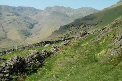
Bowfell and Esk Pike from Old Dungeon Ghyll
Lake District Walk
Nat Park - Lake District - Lake District Southern Fells
Wainwrights - Bowfell, Esk Pike
County/Area - Cumbria
Author - Lou Johnson
Length - 8.8 miles / 14.2 km Ascent - 3440 feet / 1042 metres
Time - 7 hours 50 minutes Grade - hard
Maps 

| Ordnance Survey Explorer OL6 | Sheet Map | 1:25k | BUY |
| Anquet OS Explorer OL6 | Digital Map | 1:25k | BUY |
| Ordnance Survey Landranger 90 | Sheet Map | 1:50k | BUY |
| Anquet OS Landranger 90 | Digital Map | 1:50k | BUY |
Walk Route Description
Click image to visit gallery of 6 images.
The high fells surrounding Scafell Pike all have their own character. This Lake District circular walk embraces two old favourites, Bowfell and Esk Pike, each having something different to offer the walker. Taking the easiest line of approach the walks begins at the small public car-park adjacent to the Old Dungeon Ghyll Hotel in Great Langdale. Almost certainly inadequate on a good day in summer, you are advised to arrive early if you want to be sure of a space.
Heading to Stool End farm, you have a section of flat to get those legs going. Ahead are the objectives for the day looking every bit as impressive as you had imagined. Reaching the farm, the public right of way is clearly marked and soon you are starting the uphill toil. The Band is a spur of high ground between wild Oxendale and Mickleden. At times it is a tedious climb, although excellent views of the Langdale Pikes and the Crinkle Crags do relieve some of the monotony. Surprisingly Bowfell is hidden from view for much of the climb and it is not until you have reached around 1800ft (540m) that it comes into view.
With the first objective clearly in view the climb becomes easier and with the aid of superb path reconstruction you are soon at Three Tarns. This col is a suitable resting place with an excellent view. Eskdale, the Scafells, a retrospective view down the Band into Langdale plus much, much more give you plenty to absorb. Suitably rested the onward ascent continues. Not as bad as it looks, you climb rapidly traversing across the top edge of the Great Slab to reach the summit cairn on Bowfell.
As befits the sixth highest peak in Lakeland, the views from Bowfell are extensive with the Scafells dominating the scene. However do not ignore the rest of Lakeland, which is laid out below you. Away to the east the Helvellyn Massif fills the skyline, whilst nearer to hand are Glaramara and the fells of Borrowdale. Whatever happens don't rush - you are atop one of the finest viewpoints in the Lakes. The onward route can be clearly seen. From the summit of Bowfell drop down to Ore Gap, either direct or after taking in the northern top of Bowfell. From this col climb easily to the summit of Esk Pike. Another rocky summit it again provides superb views in all directions.
Dropping down to Esk Hause be careful to take the correct path. You need to be heading for Angle Tarn and Mickleden. Satisfied you have made the correct choice enjoy the scenery as you descend to the Tarn. In a wonderful setting below the northern crags of Bowfell it is a great place to cool off and recall the day's walk. If you have the energy a quick sprint to the top of nearby Rossett Pike is worth the effort with a great view of Mickleden.
The descent of Rossett Gill is described in many books as a nightmare. What the books don't tell you is the old pony route is a delightful descent offering a gentle and interesting way down into the broad valley of Mickleden. In places the path has been flagged and I wonder how many people avoid this way into the mountains based on what they have read about Rossett Gill. Sure enough an ascent or descent of the gill itself is not a pleasant experience but the pony route is superb. All too soon you are wandering along the track back to the Old Dungeon Ghyll after a wonderful day in the mountains remembering the day's ascent of Bowfell.
Other walks nearby
| Walk 1207 | Great & Little Langdales | moderate | 8.5 miles |
| Walk 2042 | The Langdale Pikes with an ascent of Jack's Rake | very hard | 6.3 miles |
| Walk 2073 | Harrison Stickle, Pike o'Stickle & Rosset Pike | moderate | 8.3 miles |
| Walk 1736 | Langdale Pikes and High Raise FROM New Dungeon Ghyll | mod/hard | 6.1 miles |
| Walk 1144 | Lingmoor Fell | moderate | 8.0 miles |
| Walk 1171 | Pike o' Blisco | moderate | 5.0 miles |
| Walk 2582 | Pike o' Stickle, Harrison Stickle & Pavey Ark | moderate | 6.0 miles |
| Walk 3508 | The Crinkle Crags from Wrynose Pass | easy/mod | 5.0 miles |
| Walk 1134 | Wetherlam and The Carrs | mod/hard | 10.8 miles |
| Walk 2270 | Tilberthwaite and Holme Fell Little Langdale | easy/mod | 5.5 miles |
Recommended Books & eBooks
Lake District: Low Level and Lake Walks
 This guidebook describes 30 of the best low-level walks in the Lake District. From delightful wooded glades and sparkling tarns, to waterfalls and glacier-carved valleys towered over by craggy mountains. The walks described aim to seek out the best walking that the lower areas of the Lake District have to offer.
More information
Walking the Lake District Fells - Mardale and the Far East
 Part of the Walking the Lake District Fells series, this guidebook covers a wide range of routes to 36 Lakeland summits that can be climbed from the Ullswater, Haweswater, Troutbeck, Kentmere and Longsleddale valleys, with highlights including High Street, Place Fell and the Kentmere fells. Suggestions for longer ridge routes are also included.
More information
Messaging & Social Media
Message Walking Britain and follow the latest news.

Mountain Weather
Stay safe on the mountains with detailed weather forecasts - for iOS devices or for Android devices.