Moel Ysgyfarnogod & Foel Penolau
Snowdonia/Eryri Walk
Nat Park - Snowdonia - Rhinogs
County/Area - Gwynedd
Author - Lou Johnson
Length - 6.5 miles / 10.6 km Ascent - 1420 feet / 430 metres
Time - 4 hours 40 minutes Grade - moderate
Maps 

| Ordnance Survey Explorer OL18 | Sheet Map | 1:25k | BUY |
| Anquet OS Explorer OL18 | Digital Map | 1:25k | BUY |
| Ordnance Survey Landranger 124 | Sheet Map | 1:50k | BUY |
| Anquet OS Landranger 124 | Digital Map | 1:50k | BUY |
Walk Route Description
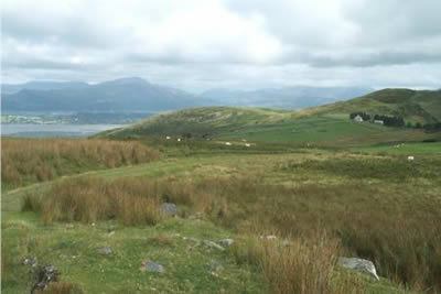
Click image to visit gallery of 7 images.
The northern Rhinogs provide excellent walking some of which is as tough as any in Snowdonia (Eryri). This particular walk provides a taste of the rocky wilderness without the hardships. We were fortunate to be accompanied part of the way by a retired sheep farmer who knew this area like the "back of his hand". Perhaps of greater interest was the fact his grandfather had worked in the manganese mines walking to and from work from his home in Maentwrog - a substantial hike at each end of the working day - each way being harder than this minor expedition into the hills!
This Snowdonia (Eryri) walk starts at the end of the lane (grid ref. SH629341) which heads uphill from the main A496 at Glan-y-wern. Make sure you do reach the end of the lane by going through the first gate and carrying on until the tarmac ends. Here grassy verges allow for tidy parking of around eight or nine cars. I would recommend the Ordnance Survey 1:25000 map which contains enough detail for this walk - note the 1:50000 map is not detailed enough. After parking go right through the gate and cross the stream. Follow the miner's track and do not be tempted to take the signed footpaths heading north and southwest.
The miner's track is grassy, easily graded and with a start at around 900 feet above sea level progress is fast. At first the scenery is unspectacular and you soon reach the twin lakes of Llyn Eiddew-bach and Llyn Eiddew-mawr with the track passing between them. Suddenly the terrain becomes wilder with low rocky walls breaking up the mountain slopes. To the south all the major Rhinog summits are in view complemented with excellent panoramas in other directions.
Stay with the miner's track as it gradually gains height taking care to turn right at the obvious fork (grid ref 651347) to pass remains of the manganese mines that have now almost disappeared with the passage of time. The track is well engineered with an easy gradient presumably to assist the horse drawn wagons. Climbing higher it follows a ledge cut into the western slopes of Moel Ysgyfarnogod before reaching the tiny lake of Llyn Ddu.
The miner's track ends just after passing this remote llyn with little in the way of paths to help from now on. Turning north, without gaining or losing height, the summit of Moel Ysgyfarnogod comes into view and it is an easy matter to reach the summit over rough grass slopes. The panorama is extensive in good weather (which it was not on this occasion) with much of Snowdonia (Eryri) in view.
Head northeast off the summit of Moel Ysgyfarnogod with the next objective, Foel Penolau, clearly in view. Surrounded by rock walls, the summit is harder to reach. The key is a clearly defined gully which provides the best route with some scrambling needed to gain the highest point. Of interest is the crazed rock pavement beneath your feet. With a view almost identical to that from Moel Ysgyfarnogod at least you have another chance to curse the disgusting intrusion to the surroundings caused by the construction of Trawsfynydd Nuclear Power Station.
Retrace you route down the gully to the col. Head northwest over pathless grass and bog to reach the northern shore of Llyn Dywarchen. You will pass further ruins of the manganese mines en-route before reaching drier ground and the miner's track. Soon you reach the outward route and all that remains is an easy downhill stroll back your transport.
Other walks nearby
| Walk 1191 | Rhinog Fawr & Gloyw Lyn from Cwm Bychan | mod/hard | 5.0 miles |
| Walk 2544 | Rhinog Fach circular | moderate | 8.0 miles |
| Walk 1036 | Rhinog Fach & Y Llethr | moderate | 9.0 miles |
| Walk 1194 | Bwlch Drws-Ardudwy | easy | 4.5 miles |
| Walk 3383 | Morfa Bychan from Borth-y-Gest | easy | 4.0 miles |
| Walk 2336 | Moel-y-Gest | easy/mod | 3.8 miles |
| Walk 2292 | Moel-y-Gest Porthmadog | easy/mod | 2.5 miles |
| Walk 2713 | Traverse of the Northern Rhinogs from Trawsfynydd | mod/hard | 14.0 miles |
| Walk 3227 | Rhinog Fawr and tarns | mod/hard | 15.0 miles |
| Walk 1127 | Cnicht | moderate | 6.3 miles |
Recommended Books & eBooks
Mountain Walking in Snowdonia
 Guidebook to 40 of Snowdonia's best day walks, with routes up Snowdon and Tryfan, including the Snowdon Horseshoe, Cadair Idris, Y Garn and The Rhinogs. The routes range from Grade 1 scrambles like Crib Goch or Bristly Ridge, to riverside and forest walks. Includes details of a 2-day traverse of all 15 of Snowdonia's 3000ft peaks.
More information
The Wales Coast Path
 A single guidebook to walking the whole Wales Coast Path - 1400km (870 miles) the length of Wales from Chester to Chepstow, including Anglesey, described in 57 stages. The route passes through the Snowdonia and Pembrokeshire National Parks and many AONBs and can be linked with the Offa's Dyke Path for a complete circuit of Wales.
More information
Messaging & Social Media
Message Walking Britain and follow the latest news.

Mountain Weather
Stay safe on the mountains with detailed weather forecasts - for iOS devices or for Android devices.