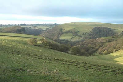
Wetton Hill & the Manifold Valley from Wetton
Peak District Walk
Nat Park - Peak District - Dovedale Manifold Valley
County/Area - Staffordshire
Author - Lou Johnson
Length - 6.5 miles / 10.6 km Ascent - 1290 feet / 391 metres
Time - 4 hours 30 minutes Grade - easy/mod
Maps 

| Ordnance Survey Explorer OL24 | Sheet Map | 1:25k | BUY |
| Anquet OS Explorer OL24 | Digital Map | 1:25k | BUY |
| Ordnance Survey Landranger 119 | Sheet Map | 1:50k | BUY |
| Anquet OS Landranger 119 | Digital Map | 1:50k | BUY |
Walk Route Description
Click image to visit gallery of 6 images.
The Staffordshire sector of the Peak District National Park is often ignored mainly because it lacks the drama of Derbyshire. However there is much to interest the walker and this relatively easy stroll has plenty to maintain your interest. The walk starts in the car park at Wetton Village (grid ref. SK108553) and follows a circular route taking in some of the highlights of this area.
To start this Peak District walk leave the car park and turn right into the lane, turning right again at the first junction. Continue down this short lane to reach a T-junction where you head left. Almost immediately on your left is a signed footpath which leads you along the hillside to Thor's Cave. Situated high above the River Manifold this local landmark provides a vantage point to look out across the valley and the countryside with the church spires of Grindon and Butterton prominent on the skyline.
Descend the recently strengthened path from the cave to the valley floor. Cross the footbridge and almost immediately opposite take the footpath that climbs steadily up through Ladyside Wood. Reaching pastures the route is a little confusing but whatever happens head for the village of Grindon. The best route exits on to the lane just to the west of Newclose Farm.
Grindon, a typical village of the area, has a pub (not always open!) and the large church is often referred to as the Cathedral of the Staffordshire Moorlands. It is worth a visit before continuing northwards along the lane leading to Ossom's Hill on the western boundary of the churchyard. Follow this farm lane until you reach a footpath on your left (grid ref. 087549) and follow this downhill towards the footbridge over Hoo Brook.
Cross the stream and follow the brook downstream in the deep valley towards the River Manifold at Wetton Mill. This is a pleasant place to rest and there is the benefit of a small cafe. From here the path passes in front of the mill house and climbs on track revealing excellent views of the Manifold Valley. The path continues up a deep dry valley to reach Pepper Inn (Manor House marked on maps?) once a hostelry for lead miners in this area.
Turn right to follow the clear path climbing across the eastern flanks of Wetton Hill. Reaching the col the short climb to the summit is worth the effort as view is first rate. Return to the col and follow the clear path back to Wetton Village. A pleasant place with an assortment of stone built cottages, the village pub seems to be open most of the day and offers suitable food and refreshment. All that remains is a short stroll back to the car park.
Other walks nearby
| Walk 2537 | Ecton Hill & Wetton from Wetton Mill | moderate | 7.0 miles |
| Walk 1021 | Milldale & Hall Dale | easy/mod | 5.0 miles |
| Walk 1257 | Wolfscote Dale | easy/mod | 7.5 miles |
| Walk 1709 | Milldale and Wolfscote Dale | easy/mod | 6.5 miles |
| Walk 3597 | Manifold Valley, Thor's Cave, Ecton & Wetton Hills from Alstonefield | moderate | 10.0 miles |
| Walk 3601 | Dove & Manifold Valleys | moderate | 10.0 miles |
| Walk 2252 | Manifold Valley and Ecton Hill | easy/mod | 6.3 miles |
| Walk 2455 | Lum Edge & Revidge Moor | easy/mod | 6.5 miles |
| Walk 3455 | Manifold Valley & Dovedale om Ilam | moderate | 9.5 miles |
| Walk 3527 | Dovedale and Manifold Valley from Ilam | moderate | 7.5 miles |
Recommended Books & eBooks
Dark Peak Walks
 Guidebook to 40 walks in the Dark Peak area of the Peak District National Park. 35 circular routes for most abilities, from 8km to 19km, around Edale, Marsden, Fairholmes, Baslow and Castleton, including Kinder Scout and Mam Tor, and 5 longer (25km to 45km) routes highlighting the best of the Gritstone Edges, High Moorland and Deep Valleys.
More information
Walking in the Peak District - White Peak East
 Guidebook describing 42 half-day and day walks in the limestone landscapes of Derbyshire's White Peak, part of the Peak District National Park. One of two volumes, this book covers the east of the region, with potential bases including Bakewell, Eyam, Castleton, Birchover, Matlock and Wirksworth.
More information
Messaging & Social Media
Message Walking Britain and follow the latest news.

Mountain Weather
Stay safe on the mountains with detailed weather forecasts - for iOS devices or for Android devices.