Y Garn from Ogwen Cottage
Snowdonia/Eryri Walk
Nat Park - Snowdonia - Glyders Tryfan
County/Area - Gwynedd
Author - Lou Johnson
Length - 4.5 miles / 7.3 km Ascent - 2110 feet / 639 metres
Time - 4 hours 20 minutes Grade - mod/hard
Maps 

| Ordnance Survey Explorer OL17 | Sheet Map | 1:25k | BUY |
| Anquet OS Explorer OL17 | Digital Map | 1:25k | BUY |
| Ordnance Survey Landranger 115 | Sheet Map | 1:50k | BUY |
| Anquet OS Landranger 115 | Digital Map | 1:50k | BUY |
Walk Route Description
Click image to visit gallery of 7 images.
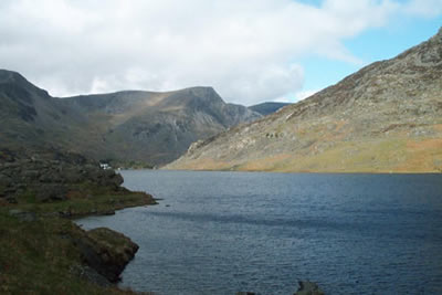
An ascent of Y Garn is a rewarding experience offering superb views over the Carneddau, Ogwen Valley, the Glyders and Snowdon. This Snowdonia (Eryri) walk is short but should not be undertaken if you only have limited experience of mountain walking. The start is at Ogwen Cottage on the A5 Bangor to Capel Curig road (grid ref. 660603) where there is a small car park and refreshment kiosk.
Take the signed footpath to Llyn Idwal, which initially sets off in a south-easterly direction but soon turns south-west. The path has recently been improved and you soon reach the footbridge over the outlet from Llyn Idwal. Situated in a superb Cwm this lake is one of the "gems" of Snowdonia (Eryri). Cross the footbridge and follow the northern shore of the lake. Leave the shore path and take the obvious route heading almost due west to begin the ascent of Y Garn.
The first section of path has seen some excellent improvements and it is not until you have gained a fair height that the path becomes loose. The route is obvious and you soon gain the final north-east ridge of Y Garn. As height is gained the view improves with Pen yr Ole Wen and the Carneddau to the north-east. To the north-west is the beautifully valley of Nant Francon with the northern peaks of the Glyders (including the famous Atlantic Slab) lining the valley. To the south Tryfan, Llyn Ogwen, Glyder fawr and Glyder Fach all vie for your attention. Quiet often summits can be an anti-climax - this is not the case with Y Garn. Occupying a superb position on steep crags the view now includes Snowdon and its satellites.
Descend over easy slopes just east of south towards the Devil's Kitchen (Do not attempt to descend the gully). Reaching Llyn y Cwn pick up the obvious path that descends in spectacular fashion to the shores of Llyn Idwal. The descent is rocky but generally easy although there are a couple of tricky sections. Do not continue all the way down to the lake side. Instead take the path that heads right towards the Idwal Slabs. (Note - this route can be problematic after heavy rain as there is an awkward crossing of a stream. In this case you need to follow the path on the western shore of Llyn Idwal). Assuming you have successfully crossed the stream it is a case of following the path beneath the Idwal Slabs to reach the footbridge you crossed at the start of the walk. It is then a short stroll back to Ogwen Cottage.
Other walks nearby
| Walk 2650 | Tryfan, the Glyders & Y Garn | very hard | 8.0 miles |
| Walk 2820 | Carneddau traverse from Llyn Ogwen | mod/hard | 14.0 miles |
| Walk 1150 | The High Carneddau | hard | 10.0 miles |
| Walk 1215 | Tryfan & Llyn Ogwen from Ogwen Valley | mod/hard | 5.5 miles |
| Walk 3001 | Tryfan North Ridge from Ogwen Valley | hard | 3.5 miles |
| Walk 3026 | Tryfan & the Eastern Tops from Ogwen Valley | hard | 5.8 miles |
| Walk 1232 | Carnedd Llewelyn, Llyn Eigiau & Llyn Cowlyd | hard | 16.0 miles |
| Walk 2855 | Gallt yr Ogof & Braich y Ddeugwm | moderate | 4.0 miles |
| Walk 3056 | Pen yr Helgi Du from Ogwen Valley | moderate | 5.5 miles |
| Walk 1074 | The Glyders Traverse | very hard | 12.0 miles |
Recommended Books & eBooks
Snowdonia: 30 Low-level and easy walks - North
 Guidebook describing 30 walks in Snowdonia, Wales. Routes are mostly low level and on clear paths and showcase the region's beautiful scenery and rich history and culture. Part of a 2-volume set, this northern volume includes the Snowdon area, the Ogwen and Conwy Valleys, Betws-y-Coed, Beddgelert, Ffestiniog and the coast.
More information
The Cambrian Way
 Guidebook to the Cambrian Way, a challenging three-week mountain trek through Wales from Cardiff to Conwy. The 470km un-waymarked route is presented from south to north. Often sticking to long, beautiful ridgelines, it crosses wild and rugged terrain and visits many of Wales's highest mountains, including Snowdon.
More information
Messaging & Social Media
Message Walking Britain and follow the latest news.

Mountain Weather
Stay safe on the mountains with detailed weather forecasts - for iOS devices or for Android devices.