Bwlch Drws-Ardudwy from Cwm Nantcol
Snowdonia/Eryri Walk
Nat Park - Snowdonia - Rhinogs
County/Area - Gwynedd
Author - Lou Johnson
Length - 4.5 miles / 7.3 km Ascent - 560 feet / 170 metres
Time - 2 hours 50 minutes Grade - easy
Maps 

| Ordnance Survey Explorer OL18 | Sheet Map | 1:25k | BUY |
| Anquet OS Explorer OL18 | Digital Map | 1:25k | BUY |
| Ordnance Survey Landranger 124 | Sheet Map | 1:50k | BUY |
| Anquet OS Landranger 124 | Digital Map | 1:50k | BUY |
Walk Route Description
Click image to visit gallery of 4 images.
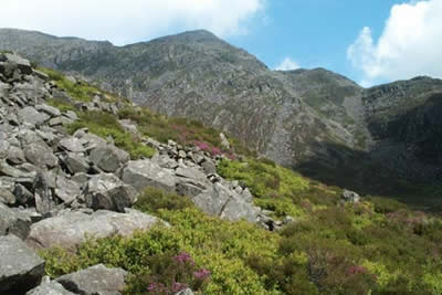
The Rhinog Mountains in Snowdonia (Eryri) have a reputation for being rugged and rocky and this may be the reason why they see few walkers compared with the better known peaks of the Snowdonia National Park. This Snowdonia walk offers a relatively easy excursion allowing you to explore the possibilities of further walking in this very special part of Wales and it gives you a real sense of being right in the mountains.
Leave the main coast road at Llanbedr (on the A496 3 miles south of Harlech) and follow the lanes inland through wonderful country to reach the broad valley of Cwm Nantcol. Continue up the lane as far as you can to reach Maes-y-garnedd, an isolated farm at the head of the valley, where parking is available for a small fee (grid ref. SH641270).
The walk itself is an out and back excursion to the col between Rhinog Fawr and Rhinog Fach. The scenery is excellent, a mixture of rock and heather with excellent views throughout. After parking go through the gate on the east side of the track and take the clear path that heads northeast. All you need to do is follow the path until you reach the col, Bwlch Drws-Ardudwy, which marked by a large cairn.
At times the way is a little boggy but generally the route offers no other difficulties. On reaching the col there is an excellent view across to Lake Trawsfynydd and the Arenigs. You can also take time to contemplate whether the Rhinogs fit your style of walking - look south from the col and you can see the steep path heading to the summit of Rhinog Fach! You might even try some off-path walking - just look out for the large rocks hidden amongst the calf high heather! Whatever your verdict the Rhinogs offer great routes, excellent scenery and ever changing panoramas - don't let the terrain put you off.
After taking in the delights of this wonderful natural rockery retrace your steps to where you parked. In two or three hours you will have discovered the delights and challenges of the Rhinog mountains. I'll wager most will be back for more!
Other walks nearby
| Walk 1191 | Rhinog Fawr & Gloyw Lyn from Cwm Bychan | mod/hard | 5.0 miles |
| Walk 2544 | Rhinog Fach circular | moderate | 8.0 miles |
| Walk 1036 | Rhinog Fach & Y Llethr | moderate | 9.0 miles |
| Walk 1193 | Y Llethr & Diffwys | mod/hard | 11.5 miles |
| Walk 1746 | Bwlch y Rhiwgyr & Pont Scethin | moderate | 9.8 miles |
| Walk 1173 | Moel Ysgyfarnogod & Foel Penolau | moderate | 6.5 miles |
| Walk 3227 | Rhinog Fawr and tarns | mod/hard | 15.0 miles |
| Walk 2713 | Traverse of the Northern Rhinogs from Trawsfynydd | mod/hard | 14.0 miles |
| Walk 1644 | Cregennen Lakes | moderate | 11.0 miles |
| Walk 1647 | Mawddach Bridge and Arthog | easy | 5.4 miles |
Recommended Books & eBooks
The Wales Coast Path
 A single guidebook to walking the whole Wales Coast Path - 1400km (870 miles) the length of Wales from Chester to Chepstow, including Anglesey, described in 57 stages. The route passes through the Snowdonia and Pembrokeshire National Parks and many AONBs and can be linked with the Offa's Dyke Path for a complete circuit of Wales.
More information
The Cambrian Way
 Guidebook to the Cambrian Way, a challenging three-week mountain trek through Wales from Cardiff to Conwy. The 470km un-waymarked route is presented from south to north. Often sticking to long, beautiful ridgelines, it crosses wild and rugged terrain and visits many of Wales's highest mountains, including Snowdon.
More information
Messaging & Social Media
Message Walking Britain and follow the latest news.

Mountain Weather
Stay safe on the mountains with detailed weather forecasts - for iOS devices or for Android devices.