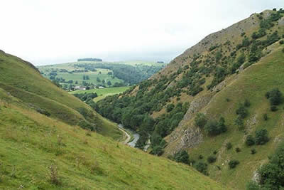
High-level Dovedale from near Thorpe Cloud
Peak District Walk
Nat Park - Peak District - Dovedale Manifold Valley
County/Area - Derbyshire & Staffordshire
Author - Lou Johnson
Length - 9.5 miles / 15.4 km Ascent - 1665 feet / 505 metres
Time - 6 hours 30 minutes Grade - moderate
Maps 

| Ordnance Survey Explorer OL24 | Sheet Map | 1:25k | BUY |
| Anquet OS Explorer OL24 | Digital Map | 1:25k | BUY |
| Ordnance Survey Landranger 119 | Sheet Map | 1:50k | BUY |
| Anquet OS Landranger 119 | Digital Map | 1:50k | BUY |
Walk Route Description
Click image to visit gallery of 5 images.
Sadly Dove Dale can be overrun with visitors with a constant procession of "walkers" filling the valley floor path especially on the southern section from Thorpe to Milldale. However there are other options and this Peak District walk goes some way to avoiding the crowds! By staying with the high ground on either side of the dale one can enjoy the views in peace and also better appreciate the excellent White Peak scenery en-route.
There is a large car park a few hundred metres south of Thorpe Cloud (grid ref. SK146508) where there are toilets and a cafe. Leave the car park and head north along the lane turning right over the first footbridge with the first objective - the shapely summit of Thorpe Cloud in view. The old path has been diverted to assist with renewal/erosion work and the approach is now from the east over a longer and easier line. The summit of this small top is soon reached and provides a good vantage point for the next stage of the walk.
Head off the summit down the steep path towards the stepping stones over the River Dove. Go through the gate and follow the main path for a few hundred metres north. Then turn right to head up the side of the dale on a clear rising path that takes you to the top of Lover's Leap. The crowds have now been left behind and apart from a short busy section at Milldale you will have the landscape to yourself for much of this round.
After enjoying the view at Lover's Leap turn east. Take the clear path that heads towards Moor Barn and continue on the waymarked route to reach a right of way that goes north (grid ref 160518) to Bostern Grange Farm. Continue through the farm to follow a farm track forking left almost immediately to stay on a northerly course across fields. At a path junction (grid ref 149541) ignore the path heading directly to Milldale instead opting for the slightly more circuitous route over Shining Tor. This offers a very pleasant approach to the hamlet of Milldale providing an excellent taste of the northern half of Dove Dale. Note that Milldale can be very busy especially during holiday weekends, which is in complete contrast to the outward high level section of the route.
In Milldale cross the bridge and take the path (signed but half hidden by the toilets) that leads steeply uphill and south along the western bank of the Dove. There is a warning notice about the path being impassable after heavy rain and this should be heeded if the river is high. The path is muddy in places (but offers a quieter route to the main path on the eastern side of the river) and leads to Hall Dale - an excellent example of a dry valley.
Stay on the west side of the river to reach Ilam Rock where a path climbs steeply up through the woods. An unofficial ( and more attractive) alternative is to head up Hall Dale to reach a signed right of way heading south (grid ref. 132540). Take this path to reach the westernmost corner of Hurt's Wood. Here climb a fence and stay within the wood's boundary following a clear path for most of the way. (Note this alternative route may involve a minor trespass?)
There now follows a pleasant high level walk along the western rim of Dove Dale to reach Air Cottage. Turn west to Ilamtops Farm and south on a signed right of way to reach Bunster Hill. There are many paths in this area but it is best to aim due south to reach a col between Bunster Hill and a small outlying top. From here the onward route to the Izaak Walton Hotel and the car park becomes obvious.
This walk was last undertaken on a busy August weekend. True there were crowds of people at the Thorpe Stepping Stones and Milldale was bustling with people. Apart from these two short stretched we saw less than a dozen people all day! Not bad for such a busy part of the Peak District National Park?
Other walks nearby
| Walk 3455 | Manifold Valley & Dovedale om Ilam | moderate | 9.5 miles |
| Walk 3527 | Dovedale and Manifold Valley from Ilam | moderate | 7.5 miles |
| Walk 1475 | Bunster Hill and Dovedale from Ilam | easy/mod | 4.5 miles |
| Walk 2259 | Ilam | easy | 4.5 miles |
| Walk 1021 | Milldale & Hall Dale | easy/mod | 5.0 miles |
| Walk 1257 | Wolfscote Dale | easy/mod | 7.5 miles |
| Walk 1709 | Milldale and Wolfscote Dale | easy/mod | 6.5 miles |
| Walk 3597 | Manifold Valley, Thor's Cave, Ecton & Wetton Hills from Alstonefield | moderate | 10.0 miles |
| Walk 3601 | Dove & Manifold Valleys | moderate | 10.0 miles |
| Walk 1181 | Wetton Hill & the Manifold Valley | easy/mod | 6.5 miles |
Recommended Books & eBooks
Walking in Derbyshire
 Walking guidebook to 60 circular day walks in Derbyshire and the Peak District. Includes the Derwent, Wye and Trent river valleys, near Derby, Matlock, Glossop, Bakewell and Ripley. Routes range from easy to moderate and are between 4 and 14km (2 to 10 miles). Walks focus on places of interest, from Stone Age forts to castles to grand estates.
More information
Great Mountain Days in the Pennines
 An inspirational guidebook to 50 classic walks on the rolling Pennine landscape. The graded routes, between 6 and 13 miles in length, cover classic Pennine fells and moorland such as Whernside, Ilkley Moor and Pendle Hill; exploring the North and South Pennines, Yorkshire Dales, Howgills and Dark Peak. Many routes are also suited to fell running.
More information
Messaging & Social Media
Message Walking Britain and follow the latest news.

Mountain Weather
Stay safe on the mountains with detailed weather forecasts - for iOS devices or for Android devices.