Ingleborough & Park Fell from Chapel-le-Dale
Yorkshire Dales Walk
Nat Park - Yorkshire Dales - Three Peaks Country
County/Area - North Yorkshire
Author - Lou Johnson
Length - 7.5 miles / 12.2 km Ascent - 1560 feet / 473 metres
Time - 5 hours 20 minutes Grade - moderate
Maps 

| Ordnance Survey Explorer OL2 | Sheet Map | 1:25k | BUY |
| Anquet OS Explorer OL2 | Digital Map | 1:25k | BUY |
| Ordnance Survey Landranger 98 | Sheet Map | 1:50k | BUY |
| Anquet OS Landranger 98 | Digital Map | 1:50k | BUY |
Walk Route Description
Click image to visit gallery of 6 images.
Ingleborough is the second highest peak in Yorkshire, over-topped by Whernside, with the summit visited by many people each year. This Yorkshire Dales walk follows a less popular route to the summit, providing an enjoyable excursion with good views of Pen-y-ghent and Whernside adding to the interest.
Parking is available in a lay-by (grid ref. SD746778) on the B6255 Ingleton to Hawes road about 2km before Ribblehead. After parking walk around 100 metres down the road towards Ingleton to take a footpath on the left signed "Ingleborough". This leads easily across fields to reach the impressive limestone pavement above South Scales Farm. The onward route is clearly marked with the path exiting onto moorland. The path on this section has been strengthened and progress is quick and easy until you reach the base of the cliffs on the western face of Ingleborough.
The path climbs steeply on a paved section (with one short section of mild scrambling) to reach the col between Simon Fell and Ingleborough. Go through the gate and follow the path onto Ingleborough's extensive summit plateau, which is adorned with a well-built wind shelter, an assortment of cairns and an OS trig column. The views in all directions are good with Pen-y-ghent and Whernside attracting your attention. On days with good visibility the Lakeland Fells look superb on the western skyline.
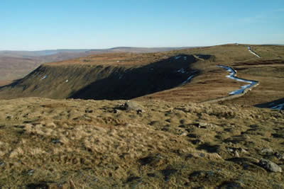
Retrace you steps to the gate and instead of descending back into the valley follow the path that heads north on the rim of the escarpment. This route offers good views down to Ribblehead viaduct with Whernside providing an equally impressive backdrop. The path continues alongside a wall over Park Fell before descending into Ribblesdale. The descent steepens before reaching grassy pastures near Colt Park Farm.
Turn left just before the farm following the blue waymarks. This path gives further views of Ribblehead viaduct and Whernside with another section of superb limestone pavement completing the walk. Reaching the road turn left and after a few minutes you are back at the lay-by.
Other walks nearby
| Walk 1184 | Whernside & Scales Moor | moderate | 11.0 miles |
| Walk 3340 | Blea Moor & Denthead from Ribblehead | moderate | 8.2 miles |
| Walk 3032 | Gragareth & Great Coum from Yordas Cave | moderate | 9.0 miles |
| Walk 3091 | Ingleton Waterfalls Walk | easy | 4.3 miles |
| Walk 1121 | Pen-y-ghent & Plover Hill | moderate | 9.0 miles |
| Walk 1013 | Pen-y-ghent | moderate | 6.5 miles |
| Walk 1500 | Pen-y-ghent via Horton Scar | moderate | 6.8 miles |
| Walk 3433 | Yorkshire Three Peaks from Horton-in-Ribblesdale | very hard | 24.5 miles |
| Walk 2146 | Deepdale Circular (near Dent) | moderate | 7.0 miles |
| Walk 1248 | Trow Gill, Ingleborough & Long Scar | moderate | 9.5 miles |
Recommended Books & eBooks
Trail and Fell Running in the Yorkshire Dales
 Guidebook to 40 of the best trail and fell runs in the Yorkshire Dales National Park. Ranging from 5 to 24 miles, the graded runs start from bases such as Ribblehead, Dent, Sedbergh, Malham and Grassington and take in the region's diverse delights, from castles and waterfalls to iconic mountains such as Whernside, Ingleborough and Pen Y Ghent.
More information
Walking in the Yorkshire Dales: North and East
 This guidebook contains 43 circular day walks in the north and east Yorkshire Dales. It explores the dales, hills and moors between Kirkby Stephen and Pateley Bridge. Walking ranges from gentle 3 mile strolls to more strenuous day-long rambles across the Howgills, Wensleydale, Swaledale, Nidderdale, Mallerstang and Coverdale.
More information
Messaging & Social Media
Message Walking Britain and follow the latest news.

Mountain Weather
Stay safe on the mountains with detailed weather forecasts - for iOS devices or for Android devices.