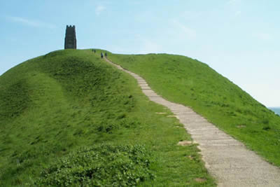
Glastonbury Tor
Somerset Walk
County/Area - Somerset
Author - Lou Johnson
Length - 2.5 miles / 4.1 km Ascent - 430 feet / 130 metres
Time - 1 hours 40 minutes Grade - easy
Maps 

| Ordnance Survey Explorer 141 | Sheet Map | 1:25k | BUY |
| Anquet OS Explorer 141 | Digital Map | 1:25k | BUY |
| Ordnance Survey Landranger 183 | Sheet Map | 1:50k | BUY |
| Anquet OS Landranger 183 | Digital Map | 1:50k | BUY |
Walk Route Description
Click image to see photo description.
Glastonbury is a small market town with a unique heritage dominated by the "Tor", which can been seen from many miles across the Somerset Levels. St. Dunstan began building a new Abbey in 950 AD and this was based around an earlier wooden church. By the Middle Ages this had become the great Benedictine Abbey the remains of which can be seen today. Glastonbury was one of the wealthiest Abbeys in the land, its Abbot playing a major part in the ruling of England. This great monastery drew pilgrims from all corners of the kingdom and helped ensure that Glastonbury became a thriving town. The Abbey was closed as a result of the dissolution of the monasteries by Henry VIII. The lead was stripped from the roofs and the buildings were left to decay.
The factual history of Glastonbury sits alongside the myths of Avalon with its links to King Arthur. More recently Glastonbury has reinforced its reputation as a special earth-sacred site where many leys meet, come together and diverge, connecting with the other power centres of the world. It is this complex mix of Christian and Pagan myths that provide the town with its unique character.
This walk starts opposite the Tourist Information Centre (grid ref ST499389) at the western end of the High Street. The Abbey is open for visitors and this can be visited either before or after completing the walk although there is admission charge. From the TIC go up High Street in an easterly direction towards the Tor. Turn right onto Wells Road and follow this to Chilkwell Street (A361). Turn left along the A361 for a short way before taking the signed footpath to the summit of the Tor. On a fine day the views are extensive from the Mendips in the north to the Quantocks in the south with the Somerset Levels forming a patchwork of fields stretching to the Bristol Channel. You can either return by the same route or alternatively you can continue north-east off the Tor and return by lanes and footpaths to the centre of Glastonbury.
Other walks nearby
| Walk 2201 | Historic Wells Circular | easy | 1.5 miles |
| Walk 1275 | Wells, North Wootton & Worminster | moderate | 9.5 miles |
| Walk 1346 | Priddy, Ebbor Gorge & Wookey Hole from Wells | moderate | 13.5 miles |
| Walk 3499 | West Compton & North Wootton from Pilton | easy/mod | 7.5 miles |
| Walk 2172 | Ebbor Gorge & Priddy from Wookey Hole | easy/mod | 6.3 miles |
| Walk 2184 | Ebbor Gorge from Wookey Hole | easy/mod | 3.0 miles |
| Walk 3304 | Pennard Hill from Pylle | moderate | 10.0 miles |
| Walk 3666 | West Mendip Way & Old Ditch from Rodney Stoke | moderate | 7.0 miles |
| Walk 3399 | Ham Woods, Croscombe & Knowle Hill from Shepton Mallet | easy/mod | 7.5 miles |
| Walk 2103 | Shepton Mallet and the Fosse Way | easy/mod | 7.5 miles |
Recommended Books & eBooks
No suggestions for this area.Messaging & Social Media
Message Walking Britain and follow the latest news.

Mountain Weather
Stay safe on the mountains with detailed weather forecasts - for iOS devices or for Android devices.