Tryfan & Llyn Ogwen from Ogwen Valley
Snowdonia/Eryri Walk
Nat Park - Snowdonia - Glyders Tryfan
County/Area - Gwynedd
Author - Lou Johnson
Length - 5.5 miles / 8.9 km Ascent - 2260 feet / 685 metres
Time - 5 hours 0 minutes Grade - mod/hard
Maps 

| Ordnance Survey Explorer OL17 | Sheet Map | 1:25k | BUY |
| Anquet OS Explorer OL17 | Digital Map | 1:25k | BUY |
| Ordnance Survey Landranger 115 | Sheet Map | 1:50k | BUY |
| Anquet OS Landranger 115 | Digital Map | 1:50k | BUY |
Walk Route Description
Click image to visit gallery of 6 images.
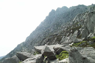
Tryfan is one of the most recognisable summits in Snowdonia (Eryri). At first sight it is an intimidating mountain having the classic pointed shape, rugged crags and a perfect position. Although a comparatively short Snowdonia walk of around 6 miles, around 2500 feet of ascent are undertaken, much of it over strenuous territory. However, it is a walk most able bodied people can undertake although it must be stressed that Tryfan is not a mountain to be treated lightly. In bad weather - snow and ice or high winds - it can be a dangerous place to be. This walk shares the first section of route with walk 3026.
You can park your car at the farm for a small charge or alongside the A5. The objective is obvious and it is an easy walk up to the right of Tryfan Bach to reach the start of the steep crags that form Tryfan. I chose the "Heather Terrace" path, which is marked on the OS 1:25000 map. The path can be clearly seen on the approach and its position should be noted. This route provides a moderate way to the summit. Picking up its start is difficult but once on it the way ahead is obvious. Quite quickly you reach the col between the Main and South peaks of Tryfan and from here it is a scramble over large rocks to the summit. Apart from one awkward section it is a straight forward scramble. The summit is a wonderful viewpoint and far below you can see the A5 threading its way alongside Llyn Ogwen. To continue return to the col first encountered on the climb up from the "Heather Terrace".
Stay on the ridge and follow the path to Bwlch Tryfan with some clambering over rocks on the way. Turn right to follow the path to Ogwen Cottage. This descends past Llyn Bochlwyd. The path is good with much reconstruction having taken place in recent years. This leads you down to the cafe and other facilities at Ogwen Cottage with good views ahead to the Carneddau and down the u-shaped valley of Nant Francon towards Bethesda.
The onward route takes along the northern shores of Llyn Ogwen. Cross the A5 and head north and cross the river bridge. There is a finger post on the north side of the A5 just over the bridge. The initial stages of the path can be hard to locate and there are a couple of large "steps" that need to be overcome before a clearer more defined route becomes apparent. If you lose the path the best option is to stay as close as you can to the river, which should be on your immediate right.
After negotiating the tricky initial section the path meanders across pleasant rocky meadows with a good view across Llyn Ogwen to Tryfan and the Glyders. Occasionally the path becomes unclear but there are cairns for most of the route which do help with navigation. The path exits onto a track and this leads back to the A5 opposite Tryfan's north ridge. All that remains is either a hike up the road or the more pleasant alternative across fields to the starting point.
Other walks nearby
| Walk 2820 | Carneddau traverse from Llyn Ogwen | mod/hard | 14.0 miles |
| Walk 1232 | Carnedd Llewelyn, Llyn Eigiau & Llyn Cowlyd | hard | 16.0 miles |
| Walk 2855 | Gallt yr Ogof & Braich y Ddeugwm | moderate | 4.0 miles |
| Walk 3056 | Pen yr Helgi Du from Ogwen Valley | moderate | 5.5 miles |
| Walk 2650 | Tryfan, the Glyders & Y Garn | very hard | 8.0 miles |
| Walk 1088 | Glyder Ridge traverse | hard | 5.5 miles |
| Walk 1186 | Y Garn | mod/hard | 4.5 miles |
| Walk 3019 | Y Garn & Carnedd y Filiast Ogwen Cottage | hard | 8.5 miles |
| Walk 3062 | Pen yr Ole Wen | moderate | 5.0 miles |
| Walk 2417 | Glyder Fach, Glyder Fawr and Tryfan from Idwal Cottage | mod/hard | 6.5 miles |
Recommended Books & eBooks
The Cambrian Way
 Guidebook to the Cambrian Way, a challenging three-week mountain trek through Wales from Cardiff to Conwy. The 470km un-waymarked route is presented from south to north. Often sticking to long, beautiful ridgelines, it crosses wild and rugged terrain and visits many of Wales's highest mountains, including Snowdon.
More information
The Wales Coast Path
 A single guidebook to walking the whole Wales Coast Path - 1400km (870 miles) the length of Wales from Chester to Chepstow, including Anglesey, described in 57 stages. The route passes through the Snowdonia and Pembrokeshire National Parks and many AONBs and can be linked with the Offa's Dyke Path for a complete circuit of Wales.
More information
Messaging & Social Media
Message Walking Britain and follow the latest news.

Mountain Weather
Stay safe on the mountains with detailed weather forecasts - for iOS devices or for Android devices.