Y Lliwedd & Snowdon from Pen-y-pass
Snowdonia/Eryri Walk
Nat Park - Snowdonia - Snowdon Crib Goch
County/Area - Gwynedd
Author - Lou Johnson
Length - 7.5 miles / 12.2 km Ascent - 3020 feet / 915 metres
Time - 6 hours 50 minutes Grade - mod/hard
Maps 

| Ordnance Survey Explorer OL17 | Sheet Map | 1:25k | BUY |
| Anquet OS Explorer OL17 | Digital Map | 1:25k | BUY |
| Ordnance Survey Landranger 115 | Sheet Map | 1:50k | BUY |
| Anquet OS Landranger 115 | Digital Map | 1:50k | BUY |
Walk Route Description
Click image to visit gallery of 6 images.
Snowdon, the highest mountain in England and Wales, is a very popular summit. Some of those reaching the top arrive by the Snowdon Mountain Railway. These people mingle with the many others who have arrived on foot. The summit is often busy and even on a quiet day is spoilt by a cafe that is best described as an eyesore. Thankfully there are many routes to the top and the one detailed here is less frequented than some of the others being used mainly by serious walkers. It is not the easiest and should only be completed by those who have some experience of mountain walking.
Starting at Pen-y-pass at the top the Llanberis Pass you have the advantage of starting relatively high above sea-level thus reducing the total ascent. The car parking here fills quite early especially in fine weather although other parking is available, which either extends the route distance or involves using the Sherpa bus service.
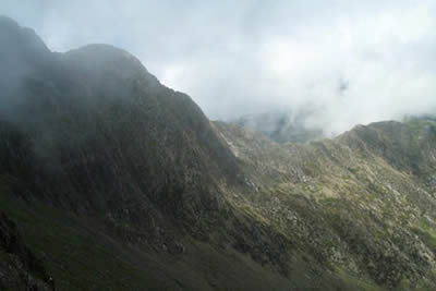
To start this Snowdonia (Eryri) walk, exit the car park to the south picking up a clear broad path. This is the Miner's Track and it provides an easy start to this fabulous walk. The path gains a little height passing Llyn Teryn to reach the shores of Llyn Llydaw. Rather than staying with the main path across the causeway, turn left and take the path heading south and up towards Y Lliwedd. The climb is steady and the first section has been flagged so progress is relatively fast. As you climb the view across Llyn Llydaw to Crib Goch is excellent and you will be able to see the steady flow of walkers crossing the ridge. As you gain height the going gets steeper and there is the need for hands as you near the ridge below Lliwedd Bach.
Reaching the ridge turn west and follow the clear path that leads over the various tops of Y Lliwedd with the final top being the highest. The views in all directions are superb (in good weather!) with a dramatic drop of over a thousand feet to Llyn Llydaw on your right - this needs be remembered in poor visibility especially when descending to Bwlch Ciliau. This section could be problematic if you veer too far to your right as you may get crag bound on the near vertical cliffs. If in doubt trend left.
Bwlch Ciliau is where the Watkin path comes up from Bethania and the number of walkers you meet will suddenly increase. You may have had Y Lliwedd to yourself but from now on be prepared to share your walk with others! The Watkin path continues ahead gaining a little height to bring you to the bottom of the steep south face of Snowdon. You now have over 700 feet of ascent over a fairly loose path that would be hard to follow in poor weather. The main path goes across the slope rather than taking a full frontal approach and this should bring you to a large marker stone on the South Ridge. Turn uphill here and you will reach the summit in less than ten minutes.
The summit of Snowdon is the busiest in Britain and sees many ill-shod visitors who have arrived by train. It also sees walkers that have arrived by a large number of routes and so having the top to yourself is a true luxury. However enjoy the view - it is stupendous with mountains and lakes in every direction, plus views across the sea, the Isle of Anglesey plus lots more!
Descent is by the Pyg Track so follow the railway downhill to reach a large marker stone at Bwlch Glas. Turn right down the paved path, which makes a large zigzag before levelling off to contour above Glaslyn. Ignore the loose descent down to the Llyn instead staying with the Pyg Track which loses height slowly as you head back to Pen-y-pass. Above to your left are the slopes of Crib Goch whilst away to your right are the peaks of Y Lliwedd conquered on the outward leg.
Reaching Bwlch y Moch (where the path up to Crib Goch starts) you get a new perspective of this wonderfully mountainous area. The view now includes the western slopes of the Glyders, Llanberis Pass, the twin lakes of Llyn Peris and Llyn Padarn together with the big crags on the eastern flanks of Snowdon. The walks is nearly over and all that remains is a downward "stroll" following the clear path to reach the car park where you started.
Other walks nearby
| Walk 2650 | Tryfan, the Glyders & Y Garn | very hard | 8.0 miles |
| Walk 1088 | Glyder Ridge traverse | hard | 5.5 miles |
| Walk 1186 | Y Garn | mod/hard | 4.5 miles |
| Walk 3019 | Y Garn & Carnedd y Filiast Ogwen Cottage | hard | 8.5 miles |
| Walk 3062 | Pen yr Ole Wen | moderate | 5.0 miles |
| Walk 2417 | Glyder Fach, Glyder Fawr and Tryfan from Idwal Cottage | mod/hard | 6.5 miles |
| Walk 1137 | Y Garn (Route 2) from Ogwen Cottage | mod/hard | 4.5 miles |
| Walk 2680 | Circuit of Llyn Idwal | easy | 2.8 miles |
| Walk 1192 | Yr Aran | mod/hard | 6.5 miles |
| Walk 1103 | Snowdon & Cwm Llan horseshoe | very hard | 13.0 miles |
Recommended Books & eBooks
The Cambrian Way
 Guidebook to the Cambrian Way, a challenging three-week mountain trek through Wales from Cardiff to Conwy. The 470km un-waymarked route is presented from south to north. Often sticking to long, beautiful ridgelines, it crosses wild and rugged terrain and visits many of Wales's highest mountains, including Snowdon.
More information
Snowdonia: 30 Low-level and easy walks - South
 Guidebook describing 30 walks in Snowdonia, Wales. Routes are mostly low level and on clear paths and showcase the region's beautiful scenery and rich history and culture. Part of a 2-volume set, this southern volume includes Trawsfynydd, Bala, Dolgellau, Machynlleth, the Harlech Coast and the valleys of the Mawddach and Dyfi.
More information
Messaging & Social Media
Message Walking Britain and follow the latest news.

Mountain Weather
Stay safe on the mountains with detailed weather forecasts - for iOS devices or for Android devices.