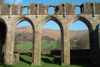
Cwmyoy & Hatterrall Hill from Llanthony Priory
Brecon Beacons/Bannau Brycheiniog Walk
Nat Park - Brecon Beacons - Brecon Beacons East
County/Area - Monmouthshire & Herefordshire
Author - Lou Johnson
Length - 10.0 miles / 16.3 km Ascent - 1980 feet / 600 metres
Time - 7 hours 0 minutes Grade - moderate
Maps 

| Ordnance Survey Explorer OL13 | Sheet Map | 1:25k | BUY |
| Anquet OS Explorer OL13 | Digital Map | 1:25k | BUY |
| Ordnance Survey Landranger 161 | Sheet Map | 1:50k | BUY |
| Anquet OS Landranger 161 | Digital Map | 1:50k | BUY |
Walk Route Description
Click image to visit gallery of 3 images.
The Black Mountains form the eastern sector of the Brecon Beacons National Park and provide excellent walking with high ridges and deep valleys. Staring from the car park at Llanthony Priory (Grid ref. SO288278) this route follows the Vale of Ewyas south to the village of Cwmyoy and its interesting church before climbing onto Hatterrall Hill where the Offa's Dyke Path is used for most of the return to the start.
Return to the valley road from the parking area, turn left and almost immediately right along a track. Take the signed footpath on your left, crossing a bridge over the Afon Honddu. After crossing the river take the left hand stile and continue along the right hand side of a field before trending half right to climb up the filed to reach a lane. Turn left passing Sunnybank and walk through the woods to reach Upper Henllan where you drop down to a ford (Grid ref. SO 290 259).
Continue on the track to Noyaddllwyd. Go past the farm but do not stay on the main track but descend left to follow a footpath that keeps to the edge of the wood with fields on your left. This path brings you to a house (Grid ref SO 286242)> From here the right of way is a path across fields to reach the valley road. Turn left along the main road taking the first road/track right. Cross the river and look out for a the hard to locate path to Cwmyoy. Once located follow this through fields to reach a lane (Grid ref. SO 295 234). Turn left and follow this lane to reach the small church, which has suffered from subsidence.
Exit the north side of the churchyard by the gate at the eastern end of the church. Turn left along a track and almost immediately turn right up a narrow enclosed footpath. Go through a gate and turn right (Grid ref. SO 299 235) to head east. Reaching a path junction (Grid ref. SO 302 235) turn left and head uphill to pass a substantial building on your right. Continue north along a pleasant level section reach a stream (Grid ref. SO 307 247). Cross the stream and after a few yards turn left along a track. The track narrows to a path and leads you onto the ridge and the summit of Hatterrall Hill.
Just past the highest point you will join the Offa's Dyke Path which is followed north. With easy gradients progress is fast and you can enjoy the excellent views on both sides of the path. Care is needed with navigation and you should regularly check your progress with the map. After approximately 3 miles you will reach a path junction (Grid ref. SO 290 295) with a stone marker. Turn left to descend to Llanthony Abbey and the start. Once located the onward route is straightforward with an easy descent.
Other walks nearby
| Walk 3622 | Llanthony Priory from Longtown | mod/hard | 7.0 miles |
| Walk 3204 | Hay Bluff & Twmpa | moderate | 10.3 miles |
| Walk 2935 | Llanthony Priory from Capel-y-ffin | easy/mod | 7.7 miles |
| Walk 1660 | Craswall Priory & Hay Bluff | easy/mod | 6.0 miles |
| Walk 1238 | Hay Bluff & Twmpa Circular | moderate | 6.0 miles |
| Walk 1271 | Sugar Loaf circular | moderate | 6.0 miles |
| Walk 1664 | The Sugar Loaf | easy | 3.5 miles |
| Walk 1106 | Waun Fach | mod/hard | 7.5 miles |
| Walk 2065 | Waun Fach & Y Grib from Pengenfford | moderate | 6.5 miles |
| Walk 3717 | Table Mountain from Crickhowell | easy/mod | 5.0 miles |
Recommended Books & eBooks
Walking in Carmarthenshire
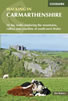 Guidebook to 30 walking routes (2 to 10 miles) in Carmarthenshire, south Wales, including sections of Carmarthenshire Coast Path. Walks for all abilities, including coastal, river, forest and hill walks in Cambrian Mountains, Tywi Valley, Y Mynydd Du (Black Mountains) and Brecon Beacons. Easy access from Bristol, Cardiff and Swansea.
More information
Walking on the Brecon Beacons
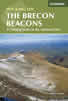 45 circular day walks are described in this guidebook to the Brecon Beacons National Park. From west to east, Mynydd Du, Fforest Fawr, the Brecon Beacons and the Black Mountains these mountain and valley routes offer many options, highlighting the natural features. The walks described explore dramatic waterfalls, wooded gorges and upland valleys.
More information
Messaging & Social Media
Message Walking Britain and follow the latest news.

Mountain Weather
Stay safe on the mountains with detailed weather forecasts - for iOS devices or for Android devices.