Gordale Scar & Malham Cove from Malham
Yorkshire Dales Walk
Nat Park - Yorkshire Dales - Malhamdale
County/Area - North Yorkshire
Author - Lou Johnson
Length - 6.5 miles / 10.6 km Ascent - 950 feet / 288 metres
Time - 4 hours 10 minutes Grade - easy/mod
Maps 

| Ordnance Survey Explorer OL2 | Sheet Map | 1:25k | BUY |
| Anquet OS Explorer OL2 | Digital Map | 1:25k | BUY |
| Ordnance Survey Landranger 98 | Sheet Map | 1:50k | BUY |
| Anquet OS Landranger 98 | Digital Map | 1:50k | BUY |
Walk Route Description
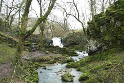
Click image to visit gallery of 9 images.
The village of Malham has become a focal point for exploring the limestone scenery of the southern half of the Yorkshire Dales. This popularity is solely due to the spectacular nature of the surrounding countryside with Malham Cove of particular note. Alternative, longer routes are described in walk 1051 and walk 2602.
This Yorkshire Dales walk combines popular paths with some less walked routes and includes some of the highlights of the area in a circular walk. The walks starts in the National Park car park (grid ref. SD900627) which has the benefit of toilets and an information centre. Exit the car park and turn left into the village. After 200 metres cross the road and follow Malham Beck upstream to the first pedestrian bridge. Cross this and head downstream following the Pennine Way until a path junction near Mires Barn (grid ref. SD902624). Turn left and follow the well maintained path east and then north to enter pleasant woodland with Gordale Beck on your right.
The path continues easily to Janet's Foss, a pretty waterfall cascading into a pool. Climb the path to the left of the waterfall and join Gordale Lane. Turn right and continue along the lane for a short way to locate a signed footpath on the left. Note that sometimes an ice-cream van parks close by obscuring the sign! The path climbs steadily uphill with a wall on your right and continues to reach Malham Rakes lane. During the initial part of the ascent the limestone escarpment of Gordale Scar is behind you on your right.
Turn right along the lane before continuing on a signed footpath on the left that leads you directly to the lip of Malham Cove where care is needed in wet weather as the limestone is very slippery. As you drop down to limestone pavement at the top of the Cove take note of the dry valley heading north as this will be used for the next section of the route.
After enjoying the view make for the dry valley, Watlowes, and follow the clear path northwards. After about a kilometre the path climbs some steps before doing a zigzag and passing between Comb Hill and Dean Moor Hill. After this point the path becomes less stony and levels off. Shortly afterwards a path enters from the right and this is where you will see a Sink Hole - the point where the stream issuing from Malham Tarn disappears below ground. This water does not form Malham Beck as one would expect but feeds a stream that surfaces south of Malham village.
Reaching a metalled road you have the option of continuing ahead to see Malham Tarn although for the purposes of this route we are about to turn south on the wide grassy track that runs roughly parallel but to the west of the path you have just used. Stay on this grassy track until an obvious path veers south (grid ref 890653) and follow this over undulating grassland to reach the zigzag encountered on the outward route. Instead of retracing your steps down the dry valley stay on the grassy path and walk south. You will almost immediately walk past a superb limestone pavement on your left before starting to descend to Cove Road. It is from this section that you are treated with a fine view of Malham Cove without hindrance from the crowds that use the main "motorway" from the village.
Reaching Cove Road turn right and climb for a hundred metres or so before taking the signed footpath on the left. This leads into the pleasant walled green lane marked as "Long Lane" on maps. Continue down the lane to reach a T-junction. Turn left and soon the lane will lead you back to the start.
Other walks nearby
| Walk 1282 | Malham Tarn & Arncliffe | moderate | 12.5 miles |
| Walk 3092 | Malham Cove, Malham Tarn & Watlowes | easy | 4.4 miles |
| Walk 2385 | Airton & Bell Busk Circular | easy/mod | 6.8 miles |
| Walk 1377 | Calton and Hanlith Moors | easy/mod | 6.5 miles |
| Walk 2066 | Winterburn Reservoir circular | easy | 6.0 miles |
| Walk 1701 | Bordley Hall & Malham Moor from Threshfield Moor | easy/mod | 7.0 miles |
| Walk 2332 | Mastilles Lane & Bordley from Kilnsey | easy/mod | 6.8 miles |
| Walk 3107 | Flasby Fell from Flasby | easy/mod | 6.5 miles |
| Walk 3109 | Rylstone Edges & Cracoe from Rylstone | easy/mod | 6.0 miles |
| Walk 2617 | Nappa Cross & Victoria Cave from Langcliffe | moderate | 9.5 miles |
Recommended Books & eBooks
The Pennine Way - the Path, the People, the Journey
 A portrait of the The Pennine Way, Britain's oldest and best known long-distance footpath, stretching 268 miles from the Peak District to the Scottish Borders. This personal, thoughtful and often humorous story of the path's remarkable history, includes the experiences of walkers and local characters on this exhilarating and complex path.
More information
Walking in the Yorkshire Dales: North and East
 This guidebook contains 43 circular day walks in the north and east Yorkshire Dales. It explores the dales, hills and moors between Kirkby Stephen and Pateley Bridge. Walking ranges from gentle 3 mile strolls to more strenuous day-long rambles across the Howgills, Wensleydale, Swaledale, Nidderdale, Mallerstang and Coverdale.
More information
Messaging & Social Media
Message Walking Britain and follow the latest news.

Mountain Weather
Stay safe on the mountains with detailed weather forecasts - for iOS devices or for Android devices.