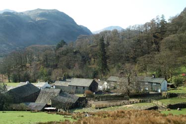
Castle Crag & Grange from Seatoller
Lake District Walk
Nat Park - Lake District - Lake District North Western Fells
Wainwrights - Castle Crag
County/Area - Cumbria
Author - Lou Johnson
Length - 6.0 miles / 9.8 km Ascent - 1400 feet / 424 metres
Time - 4 hours 20 minutes Grade - easy/mod
Maps 

| Ordnance Survey Explorer OL4 | Sheet Map | 1:25k | BUY |
| Anquet OS Explorer OL4 | Digital Map | 1:25k | BUY |
| Ordnance Survey Landranger 90 | Sheet Map | 1:50k | BUY |
| Anquet OS Landranger 90 | Digital Map | 1:50k | BUY |
Walk Route Description
Click image to visit gallery of 6 images.
This is a popular Lake District walk starting from the small village of Seatoller in upper Borrowdale. The route can be simplified by omitting the climb to the summit of Castle Crag and dropping the short extension into the village of Grange.
The start is Seatoller reached by the B5280 from Keswick. There is a pay and display car park, which fills quickly in fine weather. Exit the car park and turn right along the road between the cottages. The road begins to climb as it heads for Honister Pass. Where the road bends to the left take the path ahead. This leads upwards quite steeply before swinging north and levelling off.
Continue on this clear path with good views of Borrowdale to your right. You cross a number of becks en-route of which Tongue Gill is the most prominent. Ahead, and looking quite diminutive, is Castle Crag. This was the lowest of Wainwright's Fells and it occupies part of what he describes as the loveliest square mile in the Lake District.
The climb to the summit of Castle Crag is worthwhile as there is a splendid view, both north and south, that encompasses the whole of Borrowdale. Return down to the main path using the same route and head through the cutting between Castle Crag and High Scawdel. The path descends now to reach the banks of the River Derwent in Low Hows Wood.
If you want to explore further then the short walk to the village of Grange is recommended. There are cafés and shops plus the often photographed bridge over the Derwent. Having explored the village retrace your steps but instead of heading back to Castle Crag remain beside the River Derwent for a pleasant walk through the woods.
Leaving the shade of the trees behind you pass through fields with the village of Rosthwaite a short diversion to your left. Remaining on the west bank of the river continue past the Youth Hostel to reach a section of path that is precarious in places with some handrails for assistance. Having cleared this section the remaining short walk back to Seatoller is straightforward.
Other walks nearby
| Walk 1175 | Combe Gill Circuit | moderate | 5.5 miles |
| Walk 1693 | Grange & Watendlath from Rosthwaite | easy/mod | 7.6 miles |
| Walk 3328 | Eagle Crag & Seargeant's Crag from Stonethwaite | moderate | 7.0 miles |
| Walk 3133 | Ullscarf and Watendlath from Stonethwaite | mod/hard | 10.0 miles |
| Walk 1444 | Great Gable (Borrowdale route) | hard | 12.0 miles |
| Walk 1114 | Scafell Pike via Corridor Route | hard | 9.5 miles |
| Walk 1236 | Styhead Tarn and Seathwaite Fell | moderate | 7.0 miles |
| Walk 1306 | Base Brown & Great Gable | mod/hard | 6.0 miles |
| Walk 2046 | Great End via the north west face from Seathwaite | very hard | 7.0 miles |
| Walk 1826 | Green Gable & Gillercomb Horseshoe | moderate | 5.5 miles |
Recommended Books & eBooks
Hadrian's Wall Path
 Hadrians Wall Path guidebook to walk the 84 mile National Trail. Described in both directions, the main description is west to east between Bowness-on-Solway and Wallsend, Newcastle, with extensions to Maryport and South Shields. With extensive historical information related to this World Heritage site and separate 1:25,000 OS map booklet included.
More information
Walking the Lake District Fells - Wasdale
 Part of the Walking the Lake District Fells series, this guidebook covers a wide range of routes to 25 Lakeland summits that can be climbed from the Wasdale, Eskdale and Ennerdale valleys, with highlights including Scafell Pike, Great Gable and Pillar. Suggestions for longer ridge routes are also included.
More information
Messaging & Social Media
Message Walking Britain and follow the latest news.

Mountain Weather
Stay safe on the mountains with detailed weather forecasts - for iOS devices or for Android devices.