Cat Bells & High Spy from Grange
Lake District Walk
Nat Park - Lake District - Lake District North Western Fells
Wainwrights - Catbells, High Spy, Maiden Moor
County/Area - Cumbria
Author - Lou Johnson
Length - 8.0 miles / 13 km Ascent - 2600 feet / 788 metres
Time - 6 hours 40 minutes Grade - moderate
Maps 

| Ordnance Survey Explorer OL4 | Sheet Map | 1:25k | BUY |
| Anquet OS Explorer OL4 | Digital Map | 1:25k | BUY |
| Ordnance Survey Landranger 90 | Sheet Map | 1:50k | BUY |
| Anquet OS Landranger 90 | Digital Map | 1:50k | BUY |
Walk Route Description
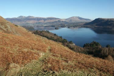
Click image to visit gallery of 12 images.
This Lake District walk combines some of the best scenery in Lakeland with views of many of the highest fells including Scafell Pike, Helvellyn and Skiddaw. As a bonus the beautiful valleys of Newlands and Borrowdale are also seen.
The walk starts from the village of Grange just off the B5289 from Keswick to Seatoller. Limited parking (Grid ref. NY253174) is available in the village or off the main valley road a short distance away. Head west through the village towards Manesty and Swinside. Passing the Borrowdale Gates Hotel on your right stay on the lane until just after Manesty.
Turn left and begin the climb, ignoring the path that forks off to the right. This path leads you quickly up to Hause Gate (Grid ref. 244192) and a path 'cross-roads'. Turn right and make your way to the summit of Cat Bells from where a grand view can be enjoyed.
Return to Hause Gate and continue south on a clear path to climb onto Maiden Moor. Nearing the top of the first ascent look out for the viewpoint on your left that offers an excellent view of Derwentwater. Reaching flatter ground the main path heads in a beeline across the moor. A better option is to bear right and follow a less distinct path that stays on the western edge of the moor offering views into Newlands and across to the fells of the Grasmoor massif.
The edge path eventually joins the main path again and continues across rougher ground to reach the large beehive cairn that marks the summit of High Spy. From here descend towards Dalehead Tarn picking up a path on your left (Grid ref. 232155) that leads down towards Rigghead Quarries.
Descending quickly through the remains of the quarries and mines you will notice many entrances to the mine workings. These should only be explored by those with suitable experience. The path descends to cross Tongue Gill on stepping stones. Keeping left you join the path from Seatoller and continue past Castle Crag to descend to the banks of the River Derwent. Turn north alongside the river joining a broader track to reach a lane. Turn right along the lane and within a couple of minutes you will be back at the start.
Other walks nearby
| Walk 1444 | Great Gable (Borrowdale route) | hard | 12.0 miles |
| Walk 1108 | Ashness Bridge & Grange Fell | moderate | 9.0 miles |
| Walk 2525 | Standing Crag & Dock Tarn from Watendlath | moderate | 7.0 miles |
| Walk 2526 | Standing Crag, Ullscarf & Borrowdale | mod/hard | 10.0 miles |
| Walk 1693 | Grange & Watendlath from Rosthwaite | easy/mod | 7.6 miles |
| Walk 1187 | Robinson & Hindscarth | mod/hard | 6.5 miles |
| Walk 2036 | Cat Bells from Gutherscale | easy/mod | 4.0 miles |
| Walk 3525 | Cat Bells (Route 2) | easy/mod | 4.0 miles |
| Walk 3119 | The Newlands Horseshoe - Catbells, Dale Head & Hindscarth | mod/hard | 12.0 miles |
| Walk 1245 | Castle Crag & Grange | easy/mod | 6.0 miles |
Recommended Books & eBooks
The Cumbria Way
 A guidebook to the 73 mile Cumbria Way, an easy long-distance walk though the heart of the Lake District National Park, from Ulverston in the south to Carlisle in the north, with good transport links to either end. The route is largely low-level but this guide offers alternative mountain days to climb some of the famous fells en route.
More information
Outdoor Adventures with Children - Lake District
 Guidebook to 40 outdoor adventures in the Lake District with children under 12, including walking, cycling, orienteering, paddling, boating, hostelling and more. Graded activities for varying age ranges or for families with children of different ages.
More information
Messaging & Social Media
Message Walking Britain and follow the latest news.

Mountain Weather
Stay safe on the mountains with detailed weather forecasts - for iOS devices or for Android devices.