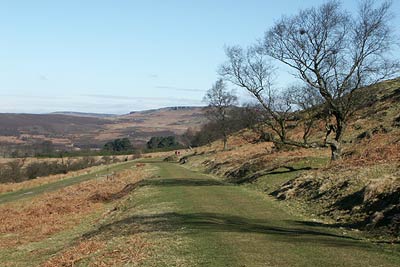
Burbage Rocks & Padley Gorge from Hay Wood
Peak District Walk
Nat Park - Peak District - Gritstone Edges Higger Tor
County/Area - Derbyshire
Author - Lou Johnson
Length - 11.0 miles / 17.9 km Ascent - 2040 feet / 618 metres
Time - 7 hours 30 minutes Grade - moderate
Maps 

| Ordnance Survey Explorer OL1 | Sheet Map | 1:25k | BUY |
| Anquet OS Explorer OL1 | Digital Map | 1:25k | BUY |
| Ordnance Survey Explorer OL24 | Sheet Map | 1:25k | BUY |
| Anquet OS Explorer OL24 | Digital Map | 1:25k | BUY |
| Ordnance Survey Landranger 110 | Sheet Map | 1:50k | BUY |
| Anquet OS Landranger 110 | Digital Map | 1:50k | BUY |
| Ordnance Survey Landranger 119 | Sheet Map | 1:50k | BUY |
| Anquet OS Landranger 119 | Digital Map | 1:50k | BUY |
Walk Route Description
Click image to visit gallery of 6 images.
This is a lengthy Peak District walk that takes in many of the highlights of the Peak District National Park in the vicinity of the Longshaw Estate. The start is a small car park (Grid ref. SK255777) at Hay Wood off the B6054 above Froggatt village near the Grouse Inn.
Exit the car park and take the field path that leads to the main road by the Grouse Inn. Turn left along the main road and cross at the footpath sign to take a clear path heading east towards White Edge. Reaching the edge (Grid ref. SK 266778) turn left. Continue north across open moorland to reach a road junction (Grid ref. SK 268789). Go straight across and follow the gated drive leading to Longshaw Lodge where refreshments are usually available in the National Trust cafe. Continue north along the drive to reach a road (Grid ref. SK 265801). Turn right along the road for a short way and cross over to take the footpath on the left. Bear right at the first junction to reach a main road.
Cross over and take the right hand of two tracks. This leads up onto Burbage Moor offering fine views across to Higger Tor. Stay on the higher level passing above the quarries and follow the top level of Burbage Rocks. This is a popular place for climbers. Reaching a road (Grid ref. SK 262829) turn left crossing Upper Burbage Bridge. Take the first path on your left and follow this to Higger Tor.
Descend from Higger Tor towards Carl Wark and continue past the remains of this ancient fort to reach the main road (Grid ref. SK 260807). Cross this busy road and turn left. Take the first path on your right. This path descends to a footbridge. Cross the bridge and continue downhill into pleasant woodland that cloaks Padley Gorge. Note the occasional discarded millstones along the path. Do not be tempted to descend to cross the stream instead continue with the stream to your left to reach an open area with the backs of houses in view (Grid ref. SK 249790).
Ignore the gravel road descending towards Grindleford station instead turning right to contour on a clear path through woodland to reach the obvious remains of the incline that once served Bole Hill quarries. Descend this incline to reach a road/track. Turn left to pass Padley Chapel, which is well worth a closer look. Continue past the station and look for a steep rising path on your left. Take this and climb up to a road. Go straight across along the residential road opposite. After approximately 300 metres turn left at the second of two footpaths. This leads uphill into woodland. The route is hard to describe with many paths in evidence. However at the first major junction fork left, which should lead after a short climb back to the start.
Other walks nearby
| Walk 1093 | Higger Tor & Burbage Rocks | easy/mod | 5.3 miles |
| Walk 1240 | Curbar, Froggatt & White Edges | easy/mod | 8.0 miles |
| Walk 1169 | Baslow Edge & Wellington's Monument | easy | 3.5 miles |
| Walk 1014 | Coombs Dale, Longstone Edge & Pilsley from Calver | moderate | 10.0 miles |
| Walk 2548 | Stanage Edge from Hathersage | moderate | 8.5 miles |
| Walk 1539 | Flask Edge and Bar Brook Moor from Shillito Wood | moderate | 9.4 miles |
| Walk 1270 | Abney Circular | easy/mod | 7.2 miles |
| Walk 3620 | Bretton Clough & Abney Moor | easy/mod | 6.0 miles |
| Walk 1479 | Burbage Moor & Redmires from near Ringinglow | easy/mod | 9.8 miles |
| Walk 1100 | Abney Moor & Bretton Clough | moderate | 8.5 miles |
Recommended Books & eBooks
Great Mountain Days in the Pennines
 An inspirational guidebook to 50 classic walks on the rolling Pennine landscape. The graded routes, between 6 and 13 miles in length, cover classic Pennine fells and moorland such as Whernside, Ilkley Moor and Pendle Hill; exploring the North and South Pennines, Yorkshire Dales, Howgills and Dark Peak. Many routes are also suited to fell running.
More information
Dark Peak Walks
 Guidebook to 40 walks in the Dark Peak area of the Peak District National Park. 35 circular routes for most abilities, from 8km to 19km, around Edale, Marsden, Fairholmes, Baslow and Castleton, including Kinder Scout and Mam Tor, and 5 longer (25km to 45km) routes highlighting the best of the Gritstone Edges, High Moorland and Deep Valleys.
More information
Messaging & Social Media
Message Walking Britain and follow the latest news.

Mountain Weather
Stay safe on the mountains with detailed weather forecasts - for iOS devices or for Android devices.