Fan y Big from Torpantau
Brecon Beacons/Bannau Brycheiniog Walk
Nat Park - Brecon Beacons - Brecon Beacons West
County/Area - Powys
Author - Lou Johnson
Length - 8.5 miles / 13.8 km Ascent - 1850 feet / 561 metres
Time - 6 hours 10 minutes Grade - moderate
Maps 

| Ordnance Survey Explorer OL12 | Sheet Map | 1:25k | BUY |
| Anquet OS Explorer OL12 | Digital Map | 1:25k | BUY |
| Ordnance Survey Landranger 160 | Sheet Map | 1:50k | BUY |
| Anquet OS Landranger 160 | Digital Map | 1:50k | BUY |
Walk Route Description
Click image to visit gallery of 9 images.
The Brecon Beacons provide miles of excellent walking. Despite appearances, the weather can soon change making the moors and escarpments difficult to navigate. This route starts with a steep climb but the way ahead soon levels off with excellent views for most of the route.
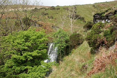
There is a small car park (Grid ref. SO056176) at Torpantau which can be reached from Merthyr Tydfil to the south and Talybont-on-Usk from the east. From the car park take the path that climbs alongside the waterfalls. The way ahead is clear and the path climbs steeply onto the moors to follow the Craig y Fan Ddu escarpment north. The views are already good especially to the east and south.
Stay on the clear path with a drop into the valley on your right. The path meanders along the escarpment gaining height almost imperceptibly as you continue along the top of Graig Fan Las to reach the northern edge of the main east-west escarpment of the Brecon Beacons (Grid ref. SO 057206). Turn left along the edge path with a grand view north to Brecon and beyond on your right.
The route is now almost level and ahead you can see Fan y Big with other peaks of the Brecon Beacons beyond. Fan y Big's summit is a pleasant place to rest a while before beginning the walk back to the start.
From the summit continue westwards descending steeply to Bwlch ar y Fan (Grid ref. SO 032206) where you turn south (left) along the 'Bwlch Road'. This track allows good progress with the Neuadd Reservoirs to your right. Looking back there is a good retrospective view to the Beacons. Where the track turns sharp right (Grid ref. SO 034182)continue ahead on a path, which skirts a plantation to reach a tarmac lane.
Do not follow the road instead fork left along the Taff Trail, which continues through the Taf Fechan Forest. After approximately one mile you reach another road. Turn left and follow this uphill back to the start.
Other walks nearby
| Walk 1552 | Waun Rydd | easy/mod | 5.5 miles |
| Walk 1123 | Brecon Beacons Horseshoe | moderate | 8.5 miles |
| Walk 2934 | The High Peaks of the Brecon Beacons | mod/hard | 10.7 miles |
| Walk 2349 | Pen Y Fan & Corn Du from near Storey Arms | moderate | 4.6 miles |
| Walk 3616 | Fan Fawr from Storey Arms | moderate | 6.0 miles |
| Walk 2400 | Pen y Fan from Cwmgwdi near Brecon | moderate | 5.0 miles |
| Walk 1903 | Pen y Fan & Corn Du from Cwmgwdi | moderate | 7.5 miles |
| Walk 2074 | Highest Peaks of the Brecon Beacons | mod/hard | 11.0 miles |
| Walk 3546 | Pen y Bryn from Pencelli | moderate | 5.0 miles |
| Walk 3536 | Pen y Bryn & Carn Pica from Pencelli | mod/hard | 11.3 miles |
Recommended Books & eBooks
Walking in Carmarthenshire
 Guidebook to 30 walking routes (2 to 10 miles) in Carmarthenshire, south Wales, including sections of Carmarthenshire Coast Path. Walks for all abilities, including coastal, river, forest and hill walks in Cambrian Mountains, Tywi Valley, Y Mynydd Du (Black Mountains) and Brecon Beacons. Easy access from Bristol, Cardiff and Swansea.
More information
The Cambrian Way
 Guidebook to the Cambrian Way, a challenging three-week mountain trek through Wales from Cardiff to Conwy. The 470km un-waymarked route is presented from south to north. Often sticking to long, beautiful ridgelines, it crosses wild and rugged terrain and visits many of Wales's highest mountains, including Snowdon.
More information
Messaging & Social Media
Message Walking Britain and follow the latest news.

Mountain Weather
Stay safe on the mountains with detailed weather forecasts - for iOS devices or for Android devices.