Ringing Roger & Edale Cross from Edale
Peak District Walk
Nat Park - Peak District - Kinder Scout Edale
County/Area - Derbyshire
Author - Lou Johnson
Length - 10.0 miles / 16.3 km Ascent - 2100 feet / 636 metres
Time - 7 hours 10 minutes Grade - moderate
Maps 

| Ordnance Survey Explorer OL1 | Sheet Map | 1:25k | BUY |
| Anquet OS Explorer OL1 | Digital Map | 1:25k | BUY |
| Ordnance Survey Landranger 110 | Sheet Map | 1:50k | BUY |
| Anquet OS Landranger 110 | Digital Map | 1:50k | BUY |
Walk Route Description
Click image to visit gallery of 2 images.
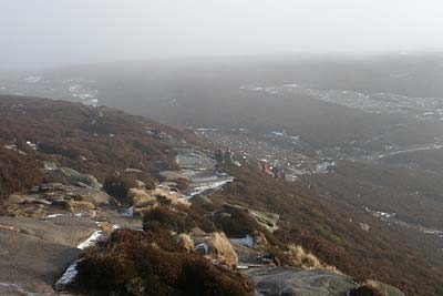
Kinder Scout and its associated area of high moorland plateau provides some of the best walks in the Peak District National Park. This walk starts from the main car park in Edale (grid ref 124853) and for once there is public transport option with Edale station served by trains on the Manchester and Stockport to Sheffield route. This route, although it follows clear paths, can be confusing in poor visibility. The pictures used to illustrate the walk were taken on such a day with ice and snow adding to the problems.
Exit the car park by the toilets and turn right along the road passing beneath the railway. Continue along this road to its end and take the signed path the Grinds Brook. The path drops to cross the stream via a bridge before continuing up the valley. You only need to stay on the main path for a short way going half right across grass up to a gate/stile and into open country. The onward path zigzags up the hillside with the rocky spur known as Ringing Roger clearly in view ahead. Reaching the base of Ringing Roger you can either scramble up through rocks to reach its summit area or continue along the western flank to exit onto the moor.
Assuming you have opted for the scramble and have reached the top of Ringing Roger , you should follow the left-hand clear path which offers good views into Grindsbrook Clough far below on your left. This path then follows the edge and continues in a roughly westerly direction past Nether Tor and Upper Tor to reach a crossing of Grinds Brook (Grid ref. SK 106876) with its small 'canyon'. With the edge still on your left continue on the path to reach a path junction (Grid ref. SK 105872). Bear right here and continue across peaty moorland to reach the point where Crowden Brook descends into the valley (SK 095873). There are many subsidiary paths on the next section which are confusing in poor visibility. However following a generally westerly route you will pass the gritstone outcrops of the Wool Packs, Pym Chair and Noel Stool to join the Pennine Way (Grid ref. SK 080865) leading you to a 'crossroads' of paths (Grid ref. SK 081861).
Turn left and, following the Pennine Way, descend Jacob's Ladder into the Vale of Edale. Ahead you can see Rushup Edge, Mam Tor and the Castleton Ridge to Lose Hill. Reach a pleasant bridge over the River Noe the path becomes a track and quick progress is made to the small community of Upper Booth.
Turn left between the buildings to locate the clearly marked onward route of the Pennine Way. The path ascends to cross the flank of Broadlee Bank before continuing across fields to reach the lane used on the outward route. Turn right and return to the car park.
Notes : If visibility is poor then this route can be confusing. It is recommended that you follow your progress on a 1:25000 map ensuring that you have correctly identified the various landmarks. The section from Crowden Tower to the Pennine Way is particularly confusing despite there being some sections of paved path.
Other walks nearby
| Walk 2522 | Rushup Edge & Edale from Mam Nick | moderate | 7.0 miles |
| Walk 1368 | Mam Tor, Upper Booth & Rushup Edge | moderate | 7.0 miles |
| Walk 1831 | Mam Tor & Hollins Cross from Mam Nick | easy | 3.0 miles |
| Walk 1688 | Old Dam & Sparrowpit from Mam Nick | moderate | 9.0 miles |
| Walk 1087 | Mam Tor & Cave Dale | moderate | 6.5 miles |
| Walk 1519 | Catleton & Speedwell Cavern Circular | easy | 4.3 miles |
| Walk 1521 | Cave Dale and Winnats Pass | easy | 4.5 miles |
| Walk 1665 | Hollins Cross & Lose Hill | easy/mod | 6.0 miles |
| Walk 3426 | Lose Hill & Hollins Cross | easy/mod | 5.0 miles |
| Walk 1489 | Blackden Brook, Kinder & Upper Ashop | moderate | 6.8 miles |
Recommended Books & eBooks
Walking in the Peak District - White Peak East
 Guidebook describing 42 half-day and day walks in the limestone landscapes of Derbyshire's White Peak, part of the Peak District National Park. One of two volumes, this book covers the east of the region, with potential bases including Bakewell, Eyam, Castleton, Birchover, Matlock and Wirksworth.
More information
Dark Peak Walks
 Guidebook to 40 walks in the Dark Peak area of the Peak District National Park. 35 circular routes for most abilities, from 8km to 19km, around Edale, Marsden, Fairholmes, Baslow and Castleton, including Kinder Scout and Mam Tor, and 5 longer (25km to 45km) routes highlighting the best of the Gritstone Edges, High Moorland and Deep Valleys.
More information
Messaging & Social Media
Message Walking Britain and follow the latest news.

Mountain Weather
Stay safe on the mountains with detailed weather forecasts - for iOS devices or for Android devices.