The Cobbler from Arrochar
Loch Lomond and Trossachs Walk
Nat Park - Loch Lomond and Trossachs
County/Area - Argyll and Bute
Author - Lou Johnson
Length - 7.5 miles / 12.2 km Ascent - 3200 feet / 970 metres
Time - 7 hours 0 minutes Grade - mod/hard
Maps 

| Ordnance Survey Explorer OL39 | Sheet Map | 1:25k | BUY |
| Anquet OS Explorer OL39 | Digital Map | 1:25k | BUY |
| Ordnance Survey Landranger 56 | Sheet Map | 1:50k | BUY |
| Anquet OS Landranger 56 | Digital Map | 1:50k | BUY |
Walk Route Description
Click image to visit gallery of 5 images.
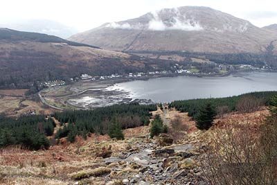
The Cobbler (also known as Ben Arthur) is a perfect objective for a walk in the Arrochar Alps. Although not reaching Munro status at 2884 ft (884 m.) it is nevertheless a memorable hill. The Cobbler rises to the west of Arrochar on Loch Long and the route described provides an enjoyable way to the summit offering the opportunity to enjoy the scenery in the area. The true summit of the Cobbler requires some scrambling skills and a head for heights so many who follow this route may not actually reach the true summit.
The start is the car park (Grid ref NN294048) adjacent to the A83 on the Inverary side of the village of Arrochar. After parking cross the road and enter the forest. You have two options either taking the new path that zigzags up the hillside or to follow the old tramway that heads directly up the hillside. This route takes the latter option which offers a steep but relatively rapid ascent of just over 1000 ft. The new path will be used for the descent.
In places the going is rough but after crossing a forest track (about a third of the way up) you reach a horizontal path. Turn left along this with good views down Loch Long and across to Arrochar. The going is fast on this section and you soon arrive at a dam. Turn uphill here to follow the Allt a' Bhalachain to get your first view of the objective.
Progress on the next section is also good along a well maintained path with height gained without too much effort. After passing the Narnain Boulders take the left fork where the path splits. The well maintained path continues for a short way until you reach the foot of steeper ground. Continue upwards following the path with occasional short sections of easy scrambling to reach the col on the main summit ridge of the Cobbler. To reach the main summit turn left although it is just as entertaining turning right for the North Summit.
Having explored the many facets of this superb mountain return to the Col where you arrived on the ridge and take the clear path across grass heading roughly north with Ben Ime almost directly ahead. Turning northeast towards Bealach a' Mhaim the descent steepens to reach the remains of a lochan.
Turning right (south east) and locate the path that follows the Allt a' Bhalachain downstream to meet the upward route. Continue on the path past the Narnain Boulders to the dam where you take the new path that zigzags down the hillside to the start.
Other walks nearby
| Walk 1493 | WHW - Day 3 - Rowardennan to Inverarnan | moderate | 14.0 miles |
| Walk 3009 | Ben Lomond | mod/hard | 7.5 miles |
| Walk 2317 | Ben Vorlich from Ardlui | mod/hard | 6.8 miles |
| Walk 1296 | Beinn Eich & Doune Hill | mod/hard | 8.0 miles |
| Walk 1494 | WHW - Day 4 - Inverarnan to Inveroran | moderate | 21.0 miles |
| Walk 2659 | Conic Hill | easy/mod | 4.0 miles |
| Walk 2418 | Inverlochlarig, Beinn a'Chroin & Beinn Chabhair | hard | 12.5 miles |
| Walk 2413 | Ben Venue from Loch Achray | moderate | 8.2 miles |
| Walk 2309 | Ben A'an from Loch Achray | easy/mod | 2.5 miles |
| Walk 2347 | Duncryne from Gartocharn | easy | 2.0 miles |
Recommended Books & eBooks
Walking Loch Lomond and the Trossachs
 A guide to walking and scrambling routes in the beautiful Loch Lomond and the Trossachs National Park. Over 70 graded low-level, mid-level and mountain walks taking in hills, glens and picturesque woodland, as well as all of the region's Munro summits. Highlights include Ben Lui, Ben Lomond, the Cobbler and the Arrochar Alps.
More information
Messaging & Social Media
Message Walking Britain and follow the latest news.

Mountain Weather
Stay safe on the mountains with detailed weather forecasts - for iOS devices or for Android devices.