Plynlimon from Esteddfa Gurig
Cambrian Mountains Walk
Region - Cambrian Mountains
County/Area - Ceredigion
Author - Peter Lane
Length - 5.0 miles / 8.1 km Ascent - 1100 feet / 333 metres
Time - 3 hours 40 minutes Grade - moderate
Maps 

| Ordnance Survey Explorer 213 | Sheet Map | 1:25k | BUY |
| Anquet OS Explorer 213 | Digital Map | 1:25k | BUY |
| Ordnance Survey Landranger 135 | Sheet Map | 1:50k | BUY |
| Anquet OS Landranger 135 | Digital Map | 1:50k | BUY |
Walk Route Description
Click image to see photo description.
Plynlimon is the highest point in mid-Wales and also the high plateau watershed from which two major rivers: the Severn and the Wye derive their source. A wild and barren place, its desolation belies its relative accessibility. This spectacular walk across barren wilderness affords panoramic views that more than rival Snowdonia (Eryri), with the added bonus that practically nobody will be there to spoil your enjoyment of it. This walk is a serious undertaking suitable only for experienced hill walkers comfortable with finding routes across trackless wilderness. This route should not be attempted in poor visibility due to a lack of defined paths and landmarks on the high plateau. It is also recommended that the 1:25,000 Explorer map be used. The ground in this area can be boggy and treacherous, so poles are recommended for testing the ground ahead. An alternative route is available at Walk 2138.
The start point for this walk is in the hamlet of Esteddfa Gurig (grid ref. SN799841). Enter the farmyard at the fingerpost and pass by a cage most likely filled with barking dogs. All the dogs were caged or tethered when I passed by, but be prepared just in case with a stick or pole. A metal gate marked "All Walks" at the time of writing ahead takes you to the side of a stream. Follow this along a well defined path initially going West and then turning North after a short while all the way up to some derelict mine workings.
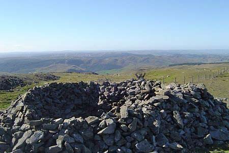
Just before reaching the mine workings, the path turns off left (watch out for the waymark). The path deteriorates into little more than a sheep track in a very short space of time. Once you get close to the summit, the path becomes more distinct and cairns guide you to the summit of Pumlumon Fawr. A ladder stile crosses the fence and a dry stone walled refuge and trig point populate the summit. The views are truly magnificent and extend 360 degrees. It is worth exploring a little trying to find other viewpoints before returning by the same route to the start.
Other walks nearby
| Walk 2048 | Craig-y-Pistyll, Cambrian Mountains | moderate | 10.0 miles |
| Walk 3086 | Pen y Garn from near Devil's Bridge | easy/mod | 6.8 miles |
| Walk 1705 | Bont-goch Circular from near Aberystwyth | easy/mod | 4.5 miles |
| Walk 1898 | Severn Valley from Llanidloes | moderate | 11.3 miles |
| Walk 2736 | Teifi Pools from near Strata Florida | easy/mod | 6.2 miles |
| Walk 1365 | Strata Florida to Tregaron | moderate | 9.5 miles |
| Walk 1420 | Borth to Aberystwyth coast | easy/mod | 6.5 miles |
| Walk 3297 | Crugyn Ci, Esgair Perfedd & Penygarreg - Elan Valley | moderate | 7.5 miles |
| Walk 1363 | The Elephant Walk from Tregaron | easy/mod | 5.5 miles |
| Walk 3317 | Happy Valley Circular | easy | 4.2 miles |
Recommended Books & eBooks
The Wales Coast Path
 A single guidebook to walking the whole Wales Coast Path - 1400km (870 miles) the length of Wales from Chester to Chepstow, including Anglesey, described in 57 stages. The route passes through the Snowdonia and Pembrokeshire National Parks and many AONBs and can be linked with the Offa's Dyke Path for a complete circuit of Wales.
More information
Messaging & Social Media
Message Walking Britain and follow the latest news.

Mountain Weather
Stay safe on the mountains with detailed weather forecasts - for iOS devices or for Android devices.