Caer Caradoc & Hope Bowder Hill from Church Stretton
Shropshire Hills Walk
Region - Shropshire Hills
County/Area - Shropshire
Author - Lou Johnson
Length - 9.0 miles / 14.6 km Ascent - 1550 feet / 470 metres
Time - 6 hours 0 minutes Grade - moderate
Maps 

| Ordnance Survey Explorer 217 | Sheet Map | 1:25k | BUY |
| Anquet OS Explorer 217 | Digital Map | 1:25k | BUY |
| Ordnance Survey Landranger 137 | Sheet Map | 1:50k | BUY |
| Anquet OS Landranger 137 | Digital Map | 1:50k | BUY |
Walk Route Description
Click image to visit gallery of 6 images.
The Shropshire countryside to the east of Church Stretton contains a selection of hills, which are made more interesting by the occasional rocky outcrops. Quieter than the Long Mynd to the west, these hills provide a number of walks each containing at least one section of ascent.
The start is the pleasant village of Church Stretton where car parking (grid ref. SO454936) is available together with a train service. Locate Sandford Avenue which runs from the traffic lights on the A49 into the main centre. Take Essex Road, which leads north from this avenue, and continue out of the village to reach a footpath sign on your right at the northern end of a sheltered housing unit (Grid ref. SO457939).
Follow this footpath across the railway to reach the A49. Cross this busy main road and continue along the track opposite. Continue across the field ahead using the stiles to reach a lane. Turn left towards New House Farm taking the second footpath on the right. This path follows the field boundary to join a track. Go through the gale and fork left down to a footbridge (Grid ref. SO 471943). Go over the bridge and turn right for a short way before turning left up a eroded path that climbs steeply. This path leads to a fence which is crossed by a stile with the onward path still climbing onto the ridge of Caer Caradoc.
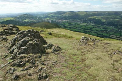
The views have improved and to your left you can see the Long Mynd whilst to the right you will note the Battle Stones on Willstone Hill which will be a feature of the second part of the walk. Eventually the slope eases and the remaining walk to the summit of Caer Caradoc is completed without expending too much more effort. The summit is an ideal place for a break and you will notice the remains of the hill fort, especially the moat.
Descend steeply north on a clear path towards the whaleback of The Lawley. Where the slope flattens turn sharp right and contour across the eastern flank of Caer Caradoc to reach a stile in a fence. Cross this stile and walk south east across the field following a feint path. This will bring you out onto a track with a finger post pointing to where you have just come from!
Go straight over the track and cross the field ahead keeping a small hill to your right. The path is hard to locate but as you near the bottom of the field you will see a stile in the fence. Cross this stile and enter a small wood. The path leads across a small bridge over the stream before climbing back out of the valley to reach a further track by a small farm building. Turn left along this track for a short way and then sharp right (Grid ref. SO 485946).
This path climbs steadily to a col on the western side of Willstone Hill. Cross the stile and continue ahead along the bridleway, which is followed all the way across Hope Bowder Hill and down to the B4371. Turn right, taking care of busy traffic, into the village. After approximately 300 metres look out on the right for a footpath. It is fairly well hidden on the left hand side of a driveway but once located should be followed across fields passing the Gaer Stone on your right to reach the B4371. Turn right along the road for a short way ignoring the first bridleway on your right. Shortly after this there is a waymarked path on your right.
Take this and follow round the right hand edge of a large field to reach a stile that provides access to Helmeth Hill. Ignore the stile instead turn left and keeping the field boundary on your immediate right, continue down the field to reach a lane, which was used for the outward route. Turn left and retrace your steps back to Church Stretton where there are plenty of opportunities for refreshment.
Other walks nearby
| Walk 3308 | Ragleth and the Long Mynd | mod/hard | 11.0 miles |
| Walk 3449 | Ragleth, the Long Mynd & Ratlinghope | hard | 18.0 miles |
| Walk 1374 | Lightspout Waterfall and Pole Bank | easy/mod | 5.8 miles |
| Walk 1180 | Pole Bank (Long Mynd) from Carding Mill | moderate | 6.5 miles |
| Walk 1409 | Haddon Hill and Bodbury Hill | easy/mod | 4.4 miles |
| Walk 2159 | Lightspout Hollow, Pole Bank & Ashes Hollow | moderate | 7.3 miles |
| Walk 1097 | Caer Caradoc | easy/mod | 3.5 miles |
| Walk 3447 | Caer Caradoc, Hope Bowdler & Willstone Hills | moderate | 7.0 miles |
| Walk 1844 | The Portway & Betchcott Hill from Picklescott | easy/mod | 5.0 miles |
| Walk 2022 | Wenlock Edge & Aston Munslow | moderate | 7.8 miles |
Recommended Books & eBooks
Hillwalking in Shropshire
 Guidebook to 32 walking routes in Shropshire in the West Midlands. The routes range from 3 miles (5km) to 12 miles (19km), taking in highlights such as The Wrekin, Wenlock Edge, Long Mynd and Stiperstones, Castle Ring and Bury Ditches. Many routes start near delightful towns and villages including Church Stretton, Ludlow and Bishops Castle.
More information
Messaging & Social Media
Message Walking Britain and follow the latest news.

Mountain Weather
Stay safe on the mountains with detailed weather forecasts - for iOS devices or for Android devices.