Green Park to Trafalgar Square
London Walk
County/Area - London
Author - Lou Johnson
Length - 2.5 miles / 4.1 km Ascent - 50 feet / 15 metres
Time - 1 hours 20 minutes Grade - easy
Maps 

| Ordnance Survey Explorer 173 | Sheet Map | 1:25k | BUY |
| Anquet OS Explorer 173 | Digital Map | 1:25k | BUY |
| Ordnance Survey Landranger 176 | Sheet Map | 1:50k | BUY |
| Anquet OS Landranger 176 | Digital Map | 1:50k | BUY |
Walk Route Description
Click image to visit gallery of 9 images.
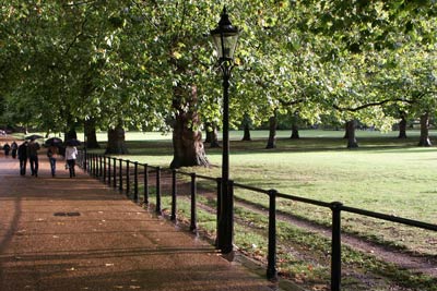
London has so many interesting features that it deserves a more leisurely approach to sightseeing than it generally receives. This walk links two of London's parks with a number of key historical landmarks and ideally should be completed at leisure.
Exit Green Park station (grid ref. TQ290803) on the south side of Piccadilly and enter Green Park taking the broad tarmac path that heads towards the Mall and Buckingham Palace. Passing Lancaster House on your left fork right to enter the Mall opposite the Queen Victoria Memorial. Buckingham Palace is to your right and no doubt you will be tempted to peer through the iron railings for a better view of the Queen's London home.
To continue turn your back on Buckingham Palace and aim for the Mall, which runs towards Trafalgar Square, taking care crossing the road to reach St James's Park. Do not walk up the Mall instead take the first path on your right into the Park. This leads you to the lake with its many water birds, which include pelicans, and a large population of friendly squirrels who seem to habitate the trees adjacent to the path. Continue along the path with the lake to your right.
Roughly half way along the lake there is a bridge. Take this and cross the lake turning left on the other side to continue along the lake which is now on your left. Reaching the eastern end of the Lake continue to the Guards Monument before crossing the road (Horse Guards) and the adjacent parade ground (Horse Guards Parade) to reach Whitehall through the colonnaded building of the Horse Guards with its mounted sentries usually in place.
Turn right along Whitehall as far as Downing Street where security fences rather spoil the view down to the Prime Minister's residence. Having taken in the "view" return along Whitehall towards Horse Guards noting the fine buildings of the Ministry of Defence and the Old War Office on the other side of the road. Passing the Whitehall Theatre on your left you reach Trafalgar Square dominated by Nelson's Column where this short but interesting walk ends.
Other walks nearby
| Walk 3013 | Trafalgar Square circular | easy | 3.0 miles |
| Walk 1570 | Westminster to Green Park via St. Paul's | easy/mod | 5.5 miles |
| Walk 3379 | Euston to the Monument via St. Paul's | easy | 4.0 miles |
| Walk 1310 | Chancery Lane to Trafalgar Square | easy | 4.0 miles |
| Walk 1442 | St Paul's Cathedral to Green Park | easy | 5.6 miles |
| Walk 3129 | Camden Town to Baker Street | easy | 2.5 miles |
| Walk 3069 | Queensway to Buckingham Palace | easy | 3.5 miles |
| Walk 1412 | The Monument to Trafalgar Square via Southwark | easy | 4.0 miles |
| Walk 2651 | The City of London from Hays Galleria | easy | 3.5 miles |
| Walk 1096 | Highbury & Islington & New River | easy | 1.5 miles |
Recommended Books & eBooks
Walking in London
 A guidebook to 25 walks in London's green spaces and nature reserves, covering both the city centre and Greater London area. Taking in woods and forests, parks and heaths, canals and rivers, the guide includes a wealth of information about some of the species you might encounter as well as the history and conservation of these areas.
More information
Messaging & Social Media
Message Walking Britain and follow the latest news.

Mountain Weather
Stay safe on the mountains with detailed weather forecasts - for iOS devices or for Android devices.