Meall a' Ghiubhais from Kinlochewe
Highland Walk
County/Area - Highland - Central Highland
Author - Lou Johnson
Length - 8.0 miles / 13 km Ascent - 2850 feet / 864 metres
Time - 6 hours 50 minutes Grade - moderate
Maps 

| Ordnance Survey Explorer 433 | Sheet Map | 1:25k | BUY |
| Anquet OS Explorer 433 | Digital Map | 1:25k | BUY |
| Ordnance Survey Landranger 19 | Sheet Map | 1:50k | BUY |
| Anquet OS Landranger 19 | Digital Map | 1:50k | BUY |
Walk Route Description
Click image to visit gallery of 9 images.
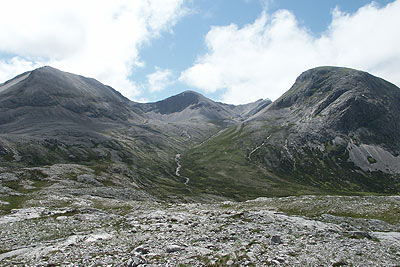
The small community of Kinlochewe is surrounded by fine hill country. This route explores one of the nearby Corbetts, namely Meall a' Ghiubhais, which rises to 886 metres. This hill together with the Munro Beinn Eighe are to be found within the boundaries of the Beinn Eighe National Nature Reserve where efforts are being made to restore the hills to their native trees and plants.
The start is the small car park at the Beinn Eighe National Nature Reserve visitor centre (Grid ref. NH020630) on the western side of the A832 approximately 1 km north of Kinlochewe. From here walk towards Kinlochewe along the main road and turn left onto a track after three hundred metres. This continues in southwesterly direction and soon becomes a well-maintained path that climbs steadily across the open hillside.
Ignore paths going right. These are part of a circular route that begins from the visitor centre. The path becomes rougher with less evidence of regular maintenance with improving views in all directions. Ignore a further path on your left to a gate in the deer fence and continue uphill crossing a few small streams. Go through the deer fence into open country and climb further to reach an area with a number of small lochans (Grid ref. NG 985625). This is also the watershed.
On your right you will see the steep slopes (with some scree) of Meall a' Ghiubhais rising to twin summits. There is no clear path and the best approach seems to be using grass as much as possible well to the right of the obvious gully containing a stream. Ascent is easier if you zig-zag and you will be surprised how quickly you reach the summit plateau. Mark the spot ready for your descent and then head southwest to the highest point of the hill.
The return is made by retracing your outward route, perhaps taking the second path on the left to utilise part of the visitor centre loop. This takes you past some interesting sculptures using wood and rock. In addition there are boards providing background information on local fauna and flora. If time permits, a visit to the visitor centre is recommended and you will be able to understand the challenges facing this ground breaking reconstruction of an ancient landscape.
Other walks nearby
| Walk 1305 | Sgurr nan Fhir Duibhe from Kinlochewe | hard | 7.5 miles |
| Walk 2116 | Beinn Eighe Route Guide | hard | 13.0 miles |
| Walk 2117 | Beinn Eighe - West to East traverse, Torridon | hard | 12.3 miles |
| Walk 2118 | Beinn Eighe traverse including Black Carls, Torridon | hard | 12.5 miles |
| Walk 2119 | Beinn Eighe - The Munros & Sail Mhor, Torridon | hard | 13.0 miles |
| Walk 2120 | The Munros of Beinn Eighe, Torridon | hard | 10.8 miles |
| Walk 3268 | Loch Coire Mhic Fhearchair (Beinn Eighe) | moderate | 8.3 miles |
| Walk 2593 | Liathach, Glen Torridon | very hard | 8.5 miles |
| Walk 1344 | Beinn Alligin & Sgurr Mor | mod/hard | 6.0 miles |
| Walk 2106 | Ullapool - a Munro Quartet including Beinn Dearg | very hard | 16.0 miles |
Recommended Books & eBooks
Great Mountain Days in Scotland
 Inspirational guidebook to 50 challenging routes for mountaineers, scramblers, hillwalkers and fell runners, many long enough to backpack over 2 days, especially in winter (12 to 25 miles). A mix of classic routes and unsung gems across Scotland from Galloway to the Outer Hebrides in widely differing wild landscapes. With customised OS mapping.
More information
Skye's Cuillin Ridge Traverse
 This 2-volume set provides all the information required to complete the main ridge traverse on Skye's Black Cuillin. Strategy, gear, training, navigation and logistics are covered, and 10 classic scrambles are described. A lightweight second guidebook gives the scrambler detailed maps, topos and route description for the ridge traverse itself.
More information
Messaging & Social Media
Message Walking Britain and follow the latest news.

Mountain Weather
Stay safe on the mountains with detailed weather forecasts - for iOS devices or for Android devices.