Burnham Green, Tewin and the Mimram Valley
Hertfordshire Walk
County/Area - Hertfordshire
Author - Barry Mackie
Length - 6.0 miles / 9.8 km Ascent - 450 feet / 136 metres
Time - 3 hours 30 minutes Grade - easy
Maps 

| Ordnance Survey Explorer 182 | Sheet Map | 1:25k | BUY |
| Anquet OS Explorer 182 | Digital Map | 1:25k | BUY |
| Ordnance Survey Landranger 166 | Sheet Map | 1:50k | BUY |
| Anquet OS Landranger 166 | Digital Map | 1:50k | BUY |
Walk Route Description
Click image to visit gallery of 9 images.
The B1000 road between Welwyn and Hertford nestles at the near the foot of the gentle slopes of the Mimram Valley. On the northern side of the valley there are numerous footpaths crossing the countryside and they offer a splendid opportunity to explore this part of rural Hertfordshire. This is a circular walk around the valley and along the River Mimram. It also passes through two villages, and should you wish to extend your route, then it is quite straightforward to visit another two or three.
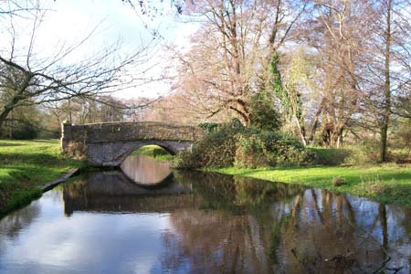
Travel along the B1000 to grid ref TL278133 where there is limited off road parking on the south side of the road. The adjacent area, which is where the walk starts, can be quite popular with picnickers in the summer, so if you can not get parked here then use the lay-by about a quarter of a mile further along the road towards Welwyn. Go through the gate on the northern side of the road to the bridge a few yards away to get a first view of the river and the small weir just downstream. Unless the water level is unusually high, it's possible to safely walk half way across the weir (without getting your feet wet). From here you get some nice views back to the bridge and also downstream as the river flowing through the meadows.
Cross the bridge and walk north for just under 100 metres to a footpath junction (grid ref. TL278135) where you continue half left across a field to reach another footpath junction. Turn left and continue with the field boundary on your immediate right to reach a small area of woodland on your right. Turn left here (south) and follow the field boundary (on your right) to reach a minor road that links the village of Tewin to the B1000. Turn right here. Stay on the road until it starts to veer to the right and heads up the incline (grid ref TL270138). Here maintain your westerly direction and leave the road following the footpath alongside the edge of the field. The river is now some twenty yards to your left. Keep going until you reach Tewin Bury Farm, a complex that includes overnight accommodation and a nice restaurant.
Turn right (north) through the courtyard and at the top end go left between the buildings to the driveway just before the car park. Walk up the driveway for a short distance until you reach a wide gap in the hedgerow on your right (grid ref TL265142) and a fine view of Tewin Church. Turn left on the narrow path through the woodland to reach Churchfield Road. Cross straight over and continue in the same direction, through woodland and alongside the fields to grid ref TL 252150.
From here, take the signed route northeast up the hill and across the fields with the path generally maintaining this direction to come out at the western side of the village green at Burnham Green. With the White Horse pub over on the far side and the shop/post office to the right of the green, this is a good place to stop for refreshments.
Turn right and follow the road to the junction, and again turn right into Orchard Road. A short distance later, just after reaching the village hall and before the junction with Tewin Close, follow the footpath sign to the right and into the field, taking the faint path (south) to the left alongside the edge of the field. Soon the direction eases to south-southeast and you reach the path into The Hundred Year Wood, which was planted by local schoolchildren in 1994. A plaque alongside the route commemorates this.
Go on this path through the wood and at the far side, walk down the byway to grid ref TL269148. Here turn left to arrive in Tewin, via Back Lane, with the Rose and Crown pub on your immediate left. With the village shop/post office a five minute walk away in Hertford Road, this also is a good place to stop for refreshments.
Cross the road and with the green on your right, walk out of the village on Hertford Road until you reach a sharp bend to the left (grid ref TL275146). Here you turn right and follow the path across the field and down the slope, taking the right fork where the path splits.
At the edge of the woods cross the small wooden bridge over the stream and go south to come out of the woods with the large house and grounds at Marden Hill now on your left. In front of you is an avenue of mature trees and on reaching it turn left and walk alongside the boundary wall (on your left) to reach a wide track at grid ref TL280138. Turn right, heading south- southwest along this track leading down the lower valley slope. Do look out for a particularly magnificent horse chestnut tree close by on your left. Soon you will be back at the bridge over the river and the end of the walk.
Other walks nearby
| Walk 1024 | Essendon to Bayford Circular | easy/mod | 10.0 miles |
| Walk 3578 | Hertford and Ware Circular | easy | 5.5 miles |
| Walk 3123 | Hertford East to Rye House | easy/mod | 8.6 miles |
| Walk 2441 | Lea Valley from Mill Green to Ware | easy/mod | 9.5 miles |
| Walk 2457 | Stanborough Park, Welwyn Garden City | easy | 2.0 miles |
| Walk 3661 | Essendon & Little Berkhamsted Circular | easy/mod | 7.4 miles |
| Walk 2799 | Ayot Green Circular | easy | 4.3 miles |
| Walk 1698 | Ware to Enfield Lock - Lea Valley - | easy/mod | 12.5 miles |
| Walk 1372 | Ayot St Lawrence Circular | easy | 6.0 miles |
| Walk 2338 | The Upper Mimram Valley | easy | 5.7 miles |
Recommended Books & eBooks
No suggestions for this area.Messaging & Social Media
Message Walking Britain and follow the latest news.

Mountain Weather
Stay safe on the mountains with detailed weather forecasts - for iOS devices or for Android devices.