Trevose Head & Constantine Bay from Porthcothan
Cornwall AONB Walk
Region - Cornwall AONB
County/Area - Cornwall
Author - Paul Deane
Length - 8.5 miles / 13.8 km Ascent - 1500 feet / 455 metres
Time - 5 hours 50 minutes Grade - easy/mod
Maps 

| Ordnance Survey Explorer 106 | Sheet Map | 1:25k | BUY |
| Anquet OS Explorer 106 | Digital Map | 1:25k | BUY |
| Ordnance Survey Landranger 200 | Sheet Map | 1:50k | BUY |
| Anquet OS Landranger 200 | Digital Map | 1:50k | BUY |
Walk Route Description
Click image to visit gallery of 6 images.
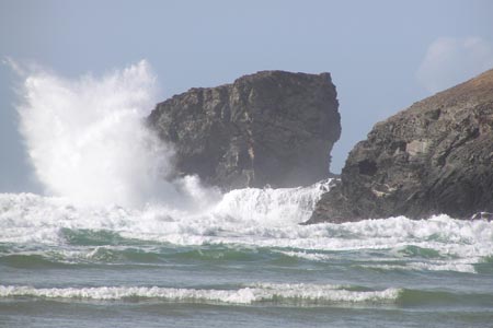
Although it has been 20 years since I walked the North Cornwall section of the South West Coast Path and most of the details have faded from my memory, the names Trevose Head and Constantine Bay are still evocative. The coastline here is about as rugged as it gets. The walk and the views are fantastic.
Start at the car park in Porthcothan (Grid ref. SW859719) and turn right on to the B3276. Head east up the bank and then turn up the first lane to your left. Follow this North for 2/3 mile. Past the caravan park you will see some holiday cottages to your right. Between these and the farm take the track off to the right. Through the farmyard the path follows the field edge to a gate. The path becomes a little indistinct in places for the next few miles. My advice is to look carefully for the stile leaving each field that you enter. If you can't see one, take a compass bearing from the map and follow it.
The path now heads NE. Follow it over the first stile then down to a fairly unique arrangement of 2 foot bridges with a stile in between (Grid ref. SW867729). After this the fields belong to dairy farms so there is no problem cutting across them. Head in a more ENE direction to an overgrown stile in the hedgerow then to the NE corner of the field beyond. The last field is arable so hug its NW boundary to a five barred gate leading to the road. Turn right on to the road, past the houses then left on to the footpath. Head ENE across the field to the overgrown stile. Once over the stile you'll find yourself at the top of a fearsome set of slippery stone steps carved into the verge of the sunken road. Take great care here!
Turn left on to the road and follow it around the right-hand bend. Continue past the houses and the chapel until you see a lane on your left. Turn on to the side lane and immediate right over the stile into the field beyond. This area seems to be mainly arable land. The path has been ploughed up so follow the boundary to your right and leave the field in its NE corner. Same story in the next field but turn left instead. Ignore the stile on the west of the field; instead walk around until you see the large break in the hedgerow. Go through the break and follow the eastern boundary of the next field.
The next stile marks the end of the arable land and the path once again becomes easy to follow as it trends NW, over a couple of stiles, and becomes a gravelly track. The track emerges on the road in the town of Constantine Bay opposite a shop (Grid ref. SW866743). Turn right and then at the golf clubhouse turn left. Follow the road around to your right, taking care of the golfers teeing off over your head. After 250m take the footpath signposted to your left. The well defined footpath now cuts through a golf course NNW for almost a mile before meeting the road opposite a T-junction. Go straight on, NW, towards the coastguard station. A mile further on (SW858762) turn right along the lane and, before you reach the houses, turn left on to the coast path.
At the top of the bank, over the stile, the path emerges out into the scrubland of Trevose Head. There's a bench to your right from where, on a clear day, you can see one of the most fantastic views that I have ever seen. The hills and cliffs stretch away to the NE. In the distance you can see the huge cliffs around Hartland Point, so big that even the intervening 40 miles doesn't seem to dwarf them. From here back to your start the route sticks to the coast path. Follow it around Trevose Head. You'll pass the lighthouse and the disused quarry before skirting the edge of the large collapsed cave known as Round Hole. At high tide, the sea crashes in the depths of this 120 foot chasm - well worth seeing.
The path trends downhill from here, following the coast towards Constantine Bay beach. Descend the wooden staircase to the beach and then walk south for about 1/2 a mile across the sand. At the southern end of the beach, join the track around Treyarnon point then join the path as it heads SSE over undulating terrain past the Youth Hostel/Cafe. You'll join another track before following the coast path waymarks over Treyarnon Bay beach.
There are two paths leading up from the beach at its southern end. I'd recommend using the left hand path as the other one looks a little tricky. At the top of the low cliff follow the coast path to your right, around the houses, then left along the hedgerow. To your right the 'settlement' marked on the map (Grid ref. SW853738) is visible as an area of earthworks. The sea has cut inlets through the earthworks and, as the land here is open access, it's worth leaving the path to have a look around.
The coast path trends southward along the cliff tops. Follow it as it weaves in and out around the curiously named inlets. The surroundings are really pretty here. There is nothing but a campsite and a few isolated farms and, with the dramatic coastline, this section alone would be worth the walk. Eventually you'll see Porthcothan beach in front of you. Follow the path down along the hillside and turn right at the road. Your start is 50 metres to your left.
Other walks nearby
| Walk 1961 | Porthcothan to Watergate Bay | easy/mod | 6.8 miles |
| Walk 3589 | Padstow from Little Petherick | easy | 5.0 miles |
| Walk 3738 | Polzeath & Pentire Point from Rock | moderate | 11.4 miles |
| Walk 1104 | Newquay to Porthcothan coast path | moderate | 10.5 miles |
| Walk 2462 | The Rumps & Pentire Point | easy/mod | 4.0 miles |
| Walk 3264 | Port Quin & Port Isaac Circular | easy/mod | 5.7 miles |
| Walk 1029 | Tintagel to Boscastle | moderate | 9.0 miles |
| Walk 1883 | Advent Church | easy | 5.2 miles |
| Walk 2294 | St. Agnes to Porthtowan | easy/mod | 5.0 miles |
| Walk 1808 | Brown Willy, exploring Cornwall's highest Tors | easy/mod | 4.0 miles |
Recommended Books & eBooks
Walking in Cornwall
 This guidebook includes routes to 40 day walks in Cornwall. From short, easy strolls to longer, wilder routes, there is plenty to appeal to both families and experienced walkers. The walks explore the interior and coasts, including walks through picturesque villages, old tin-mining areas and the Lizard and Land's End Peninsulas.
More information
Messaging & Social Media
Message Walking Britain and follow the latest news.

Mountain Weather
Stay safe on the mountains with detailed weather forecasts - for iOS devices or for Android devices.