The White Horse & Sutton Poyntz from Osmington
Jurassic Coast Walk
Region - Jurassic Coast
County/Area - Dorset
Author - Lou Johnson
Length - 4.0 miles / 6.5 km Ascent - 900 feet / 273 metres
Time - 2 hours 50 minutes Grade - easy/mod
Maps 

| Ordnance Survey Explorer OL15 | Sheet Map | 1:25k | BUY |
| Anquet OS Explorer OL15 | Digital Map | 1:25k | BUY |
| Ordnance Survey Landranger 194 | Sheet Map | 1:50k | BUY |
| Anquet OS Landranger 194 | Digital Map | 1:50k | BUY |
Walk Route Description
Click image to visit gallery of 3 images.
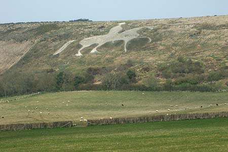
This short walk climbs onto White Horse Hill using the South West Coast Path (inland option). The White Horse can be seen on the hillside from the A353 and is popular landmark in the area. Grand views towards the sea are the reward for the climb. The route continues by visiting the village of Sutton Poyntz before returning across the fields to the start.
The village of Osmington lies to the north of the A353 east of Weymouth. The village offers limited parking near the church on the road leading north from the main road to Netherton Farm (Grid ref. SY724830). After parking descend this road and continue to Netherton Farm where the onward lane, the South West Coast Path inland route), leads you towards White Horse Hill. Initially the ascent is easy but there is a steeper section before you reach the top. During this ascent you can clearly see the White Horse to your left.
Reaching the top of the hill turn left and follow the clear path past the trig point to join a lane (Grid ref. SY710847). Go left onto the lane and immediately left again to follow a path descending around the side of Spring Bottom. Where the path splits take the right hand fork and continue across fields to a lane (Grid ref SY707839). Turn right onto a lane and follow it as it bends left into Sutton Poyntz. Continue past the pub and you are now in the centre of the village with an attractive stream flowing alongside the road.
Continue south on this road past Northdown Farm. Take the signed footpath on your left (Grid ref. SY706836). This leads across fields to a path junction (Grid ref. SY716834). Either option will take you to the road in Osmington Village. Turn right along the road and the church is a short way along on the right.
Other walks nearby
| Walk 1889 | White Nothe from Ringstead Bay | easy/mod | 5.8 miles |
| Walk 2575 | Durdle Door & Lulworth Cove | moderate | 10.0 miles |
| Walk 1004 | Durdle Door & Lulworth Cove | easy | 2.5 miles |
| Walk 1329 | Durdle Door & White Nothe from Lulworth Cove | moderate | 7.0 miles |
| Walk 3389 | Bindon Hill and the Fossil Forest from Lulworth | easy/mod | 4.0 miles |
| Walk 2370 | The Fleet from Langton Herring | easy/mod | 7.0 miles |
| Walk 3523 | Abbotsbury & Portesham Circular | easy | 5.2 miles |
| Walk 3748 | Southover Heath from Tolpuddle | easy | 5.0 miles |
| Walk 2289 | Abbotsbury Castle and Chesil Beach | easy/mod | 6.0 miles |
| Walk 2565 | Littlebredy from Abbotsbury | moderate | 8.5 miles |
Recommended Books & eBooks
South West Coast Path Map Booklet - St Ives to Plymouth
 Map of part of the southern section of the 630 mile (1014km) South West Coast Path National Trail. Covers the trail from St Ives to Plymouth along the west Cornwall and Devon coastline. This convenient and compact booklet of Ordnance Survey 1:25,000 maps shows the route, providing all of the mapping you need to walk the trail in either direction.
More information
The South West Coast Path
 Guidebook to walking the entire South West Coast Path National Trail. The route runs for 630 miles from Minehead to Poole along the north Devon, Cornish, south Devon and Dorset coastline. Divided into 45 stages, this long-distance coastal trek could be completed within 4 weeks, or walked in sections. Guide includes maps and essential information.
More information
Messaging & Social Media
Message Walking Britain and follow the latest news.

Mountain Weather
Stay safe on the mountains with detailed weather forecasts - for iOS devices or for Android devices.