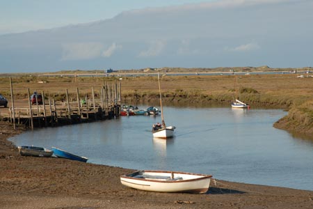
Morston Salt Marshes from Morston Quay
Norfolk Walk
County/Area - Norfolk
Author - Lou Johnson
Length - 2.5 miles / 4.1 km Ascent - 40 feet / 12 metres
Time - 1 hours 20 minutes Grade - easy
Maps 

| Ordnance Survey Explorer 251 | Sheet Map | 1:25k | BUY |
| Anquet OS Explorer 251 | Digital Map | 1:25k | BUY |
| Ordnance Survey Landranger 133 | Sheet Map | 1:50k | BUY |
| Anquet OS Landranger 133 | Digital Map | 1:50k | BUY |
Walk Route Description
Click image to visit gallery of 9 images.
This short route explores parts of the Morston Salt Marshes that are accessible on foot. The route starts from Morston Quay visitor centre (Grid ref. TG006442) which is signed from the A149 Cromer to Hunstanton road in the centre of Morston village. The walk is subject to tides and maybe wet underfoot. Times of tides are available locally and the walk should not be attempted on a rising tide as there is a danger that you may be cut off or stranded. It must also be stressed that this walk should not be attempted in mist or poor visibility as the lack of landmarks on the marshes can be disorientating.
From Morston Quay visitor centre, which offers refreshments in season, cross the parking area to walk alongside the jetties from where the boats depart for the seal trips. Cross the first footbridge and keeping the jetties on your right continue to another bridge. Cross this and walk ahead towards the South Side of the Blakeney Channel. Ahead, across the Channel, lies the former Blakeney Point Lifeboat House, which is now used by the National Trust.
The path ahead gradually fades. However, a clearer path turns west (left) and continues across the marshes to Morston Meals where an indistinct path bears left inland towards the Norfolk Coast Path. Make a note of this point and continue straight ahead to reach the shore (MHW). Depending on the season you will no doubt encounter a wide variety of birds who use this area and occasionally seals.
You will reach a point when you can make no further progress. Turn around here and walk back to the path junction identified above. Turn right (inland) and walk across Morston Greens to reach the Norfolk Coast Path. Turn left along this National Trail following the clear waymarks back to the Visitor Centre at Morston Quay, which is a useful landmark.
Note - It is worth noting that there is an excellent bus service operating along the A149 coast road between Sheringham and Kings Lynn. Operated by Norfolk County Council, this 'Coast Hopper' service is useful for many walks as the bus route shadows the Norfolk Coast Path. This enables one way walks to be undertaken with relative ease but also means that other walks can be altered to suit your needs.
Other walks nearby
| Walk 1804 | Blakeney & Cley next the Sea | easy | 5.0 miles |
| Walk 1730 | Blakeney Point | moderate | 9.0 miles |
| Walk 2401 | Salthouse from Cley-next-the-Sea | easy | 4.0 miles |
| Walk 1654 | Cley next the Sea & Salthouse | easy | 6.7 miles |
| Walk 2081 | Holkham Gap and West Beach from Wells-next-the-Sea | easy | 4.0 miles |
| Walk 1908 | Wells-next-the-Sea & Holkham Park | easy/mod | 8.0 miles |
| Walk 2101 | Holkham Park circular | easy | 4.5 miles |
| Walk 3254 | Holkham & Holkham Park Circular | moderate | 10.2 miles |
| Walk 2653 | Sheringham to Cley-next-the-Sea | easy/mod | 8.5 miles |
| Walk 1035 | Burnham Market | easy | 5.5 miles |
Recommended Books & eBooks
No suggestions for this area.Messaging & Social Media
Message Walking Britain and follow the latest news.

Mountain Weather
Stay safe on the mountains with detailed weather forecasts - for iOS devices or for Android devices.