Shatterford Wood and Castle Hill circular
Worcestershire Walk
County/Area - Worcestershire
Author - Peter Lane
Length - 5.5 miles / 8.9 km Ascent - 800 feet / 242 metres
Time - 3 hours 30 minutes Grade - easy/mod
Maps 

| Ordnance Survey Explorer 218 | Sheet Map | 1:25k | BUY |
| Anquet OS Explorer 218 | Digital Map | 1:25k | BUY |
| Ordnance Survey Landranger 138 | Sheet Map | 1:50k | BUY |
| Anquet OS Landranger 138 | Digital Map | 1:50k | BUY |
Walk Route Description
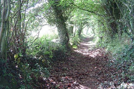
Click image to visit gallery of 12 images.
This is a rural Worcestershire walk on rolling green hills and through scarcely visited woodland. Fringing Bodenham Arboretum, the walk passes managed, landscaped woods and forestry woodland. With superb views into three counties and Kinver Edge (the walk just manages to stay in a corner of Worcestershire, sandwiched between Staffordhire and Shropshire). This walk will be a delight to any hill walker with a couple of hours to spare in North Worcestershire. The grading reflects the overgrown nature of some of the terrain and the necessary map and compass skills required to follow it confidently. Long trousers will be required and gaiters are recommended.
Parking is a little awkward, but there is a grass verge at grid reference SO812804 just a few yards before the access road to Bodenham Arboretum. With the entry details to Bodenham Arboretum on the left, ignore the access road and continue along the narrow country lane until the entrance to Kingsford Caravan Park is reached. Walk into the park and down to the main access road. Turn right down through the main access now (this is the Worcestershire Way) to the main road.
Turn left out of the Caravan park and almost immediately turn left up a narrow country lane to High Hobro Farm. Passing the farm, the lane turns left and a footpath appears on the right. Take this reasonable lane that turns into a more narrow, enclosed path as the drive ends and the path turns left. Continue along this path and turn sharp right at a junction of footpaths. This continues to be an enclosed path until it reaches a stream and opens out into a hilly field. Emerging into the field, there is a walk to the left which forms part of Bodenham Arboretum. The official right of way is to the right of this, keeping the trees to the left and rising up the hill. Continue to the end of the field (meeting up with the other end of the Bodenham walk) and proceed to Bodenham Farm.
Waymarks show the onward route to the right past the farm on the right. Continue to follow the waymarks as the footpath turns right, past a lodge and then curves left and down a rolling bank to Bottom Pool. Curve round along the path and then look uphill to the right where there is a fenced, wooded ridge with park bench (also part of the Arboretum). The right of way is up the steep hill to the ridge, which is skirted to its right flank. Passing around the nose of the wood on the summit of the ridge, a stile can be seen at the bottom of the hill opposite.
Descend to the stile and then down steep steps to a footbridge. Now climb along the flank of Coldridge Wood which is on the right. Keeping the fence to the right, climb until a stile is reached, accessing the woodland. Walk through the woods along the bridlepath, taking care to follow the blue waymarks. This hilly, excellent bridlepath seems remote and scarcely visited. Dropping to a small pond, follow the waymarks as they point along a forestry track and perform a left handed arc (deviating from the green dashed line on some Explorer maps) and then under electricity lines, continuing to the Staffordshire border.
Watch out for a bridlepath on the right that virtually doubles back on the incoming path. This curves to the left and at a farm building enters another enclosed pathway. Follow this bridlepath with superb views into three counties to the Castle Hill Estate. Follow the waymarks where the bridlepath approaches Castle Hill Farm at the summit and passing below and to the left of the Farm, emerge onto the steadily descending broad (but rough) access road to the farm with its secluded (and highly desirable!) properties.
Upon reaching Lower Kingsford Lane, turn right along this lane past what looks like another caravan park (without the wheels), but with modest holiday type chalets. There are some delightful examples of garden kitsch to be admired along the route! At the end of the lane, turn right at the end of the lane onto the main road and return shortly to the entrance to the caravan park visited at the start of the route. Retrace from here back to the start.
Other walks nearby
| Walk 2466 | The Severn Valley from Trimpley Reservoir | easy | 6.0 miles |
| Walk 3003 | Kinver Edge & Blakeshall from Holy Austin Rock | easy | 4.3 miles |
| Walk 2834 | Kinver Edge circular | easy | 4.2 miles |
| Walk 3241 | Kinver Edge & Holy Austin Rock | easy | 2.6 miles |
| Walk 1806 | Kinver Stroll | easy | 2.0 miles |
| Walk 2024 | Kinver Edge, South Staffordshire | easy/mod | 6.0 miles |
| Walk 2874 | Enville Estate and the Sheepwalks | easy | 4.0 miles |
| Walk 1933 | Wyre Forest & River Severn from Upper Arley | easy/mod | 7.6 miles |
| Walk 2131 | Wyre Forest National Nature Reserve, Bewdley | easy | 3.3 miles |
| Walk 2288 | Pound Green and Dowles Brook from Hawkbatch | easy | 5.0 miles |
Recommended Books & eBooks
No suggestions for this area.Messaging & Social Media
Message Walking Britain and follow the latest news.

Mountain Weather
Stay safe on the mountains with detailed weather forecasts - for iOS devices or for Android devices.