Ware to Enfield Lock - Lea Valley -
Hertfordshire Walk
County/Area - Hertfordshire & Essex & London
Author - Barry Mackie
Length - 12.5 miles / 20.3 km Ascent - 150 feet / 45 metres
Time - 6 hours 20 minutes Grade - easy/mod
Maps 

| Ordnance Survey Explorer 174 | Sheet Map | 1:25k | BUY |
| Anquet OS Explorer 174 | Digital Map | 1:25k | BUY |
| Ordnance Survey Landranger 166 | Sheet Map | 1:50k | BUY |
| Anquet OS Landranger 166 | Digital Map | 1:50k | BUY |
Walk Route Description
Click image to visit gallery of 11 images.
This is a riverside walk along the banks of the Lee Navigation on paths that are generally in good condition. It is part of "The Lea Valley Walk", a 50mile/80km trail through the Lea Valley between Luton and East London. The waymarker symbol is a white swan on a dark green background and for this section is surprisingly sporadic.
That said, this is a relatively straightforward walk, with only one place where you could have difficulties, but here directions are provided in the description. If you need public transport back to the start point at Ware, then the rail link will be the easiest option, and this is detailed at the end of the walk. Also if you wanted to do this walk in two sections, then Broxbourne, with its rail link back to Ware, is a good "half way" place to stop.
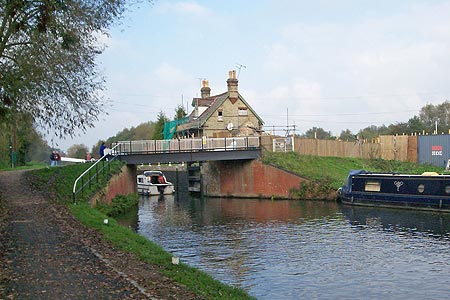
Starting at the road bridge that spans the Lee Navigation (Grid ref. TL359141), in Amwell Road, in the town of Ware, Hertfordshire, take the path alongside to the right side of the river and head east. Immediately you are in The Lee Valley Park, a 10,000 acre "green wedge" that stretches some 26 miles into East London. The park has much to offer for outdoor recreation, with walking, camping, picnic areas and boating among the many facilities on offer. There are numerous benches alongside this path, where you can sit and relax, just enjoying the surroundings.
This is probably a good point to try and explain some oddities. For example, "A Lea Valley Walk through the Lee Valley Park, Lee Navigation, River Lee or Lea, and close by us to the West, the New River So briefly; if it's Lee, then its man made, if it's Lea, then it's not! River Lee or Lea is on the OS maps, but by convention this is Lea. The New River was new some 400 years ago, but it always was a man made aqueduct.
Stay on the path on the right bank of the river for the next 5 miles/8kms to reach Dobbs Weir (Grid ref TL385082). There's plenty to see on this section, as well as the riverboats, locks and weirs. We took a slight detour across the river to get a closer look at Amwell Quarry Nature Reserve, and then had a quick look at Stanstead Abbotts. Along the path at grid ref. TL 379122 you will cross the Greenwich Meridian, that most famous of navigation lines and until you cross back over it later in the walk, you will be in the Eastern Hemisphere. Sadly at neither crossing point did we see anything to note the Meridian passing through.
At Dobbs Weir take the footbridges over the river towards the Fish and Eels Public House on your left. You are now in the county of Essex. As the path meets the road there is a rare, but welcome, waymarker that indicates the path along the left bank of the Lee Navigation for the next section. Continue on this bank for approx 1.5 miles, crossing the Meridian again at grid ref. TL380090, until you reach the Crown Public House and the Lee Valley Boat Centre. Cross the river here by the road bridge (Grid ref. TL373067) to return to the County of Hertfordshire.
For the remainder of the walk you stay on this bank, with the river to your left. Whilst much of the adjacent areas are described on the OS map as marshes, the path is decent and there are lots of opportunities to explore on both sides of the river. Less than a stone throw from the M25 motorway flyover, we spotted a heron, and whilst these birds are fairly frequently seen in Hertfordshire, it is still the case that you stop and quietly grab your camera this close to London.
Going under the flyover, you now enter Greater London in the Borough of Enfield, and with Rammey Marsh now on your right, it is not far to the finish. Approaching the end of this walk, just past the road bridge at Enfield Lock (Grid ref. TQ3710987), there is a tantalising view of how the next section may be. an imposing waymarker, some 10ft high, that shows us the route forward, but sadly that's for another day.
The walk out to the train station is straightforward. Turn right, away from the river and with the Greyhound PH on your left, go along Ordnance Road to the pedestrian crossing. Continue on in the same direction into Mollison Road to Enfield Lock train station on your left, which is about half a mile from the river.
Other walks nearby
| Walk 3352 | The Greenwich Meridian, near Ware | easy | 3.3 miles |
| Walk 1725 | St Margaret's circular via Widford | moderate | 10.2 miles |
| Walk 3123 | Hertford East to Rye House | easy/mod | 8.6 miles |
| Walk 3578 | Hertford and Ware Circular | easy | 5.5 miles |
| Walk 2348 | Bourne Valley & Sacombe from Wadesmill | easy/mod | 5.8 miles |
| Walk 1741 | Rye House circular via Roydon and Stanstead Abbots | easy/mod | 9.1 miles |
| Walk 1125 | Widford & Cold Christmas Circular | easy/mod | 9.5 miles |
| Walk 3530 | Roydon to Epping | easy/mod | 9.3 miles |
| Walk 1723 | Broxbourne Circular via Roydon | moderate | 10.3 miles |
| Walk 1402 | Burnham Green, Tewin and the Mimram Valley | easy | 6.0 miles |
Recommended Books & eBooks
No suggestions for this area.Messaging & Social Media
Message Walking Britain and follow the latest news.

Mountain Weather
Stay safe on the mountains with detailed weather forecasts - for iOS devices or for Android devices.