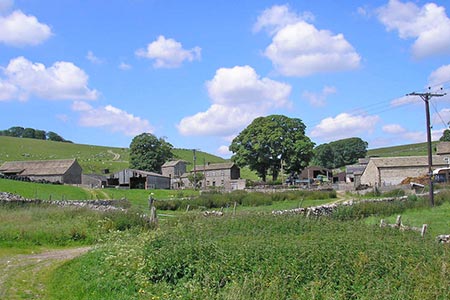
Bordley Hall & Malham Moor from Threshfield Moor
Yorkshire Dales Walk
Nat Park - Yorkshire Dales - Malhamdale
County/Area - North Yorkshire
Author - Allan Friswell
Length - 7.0 miles / 11.4 km Ascent - 900 feet / 273 metres
Time - 4 hours 20 minutes Grade - easy/mod
Maps 

| Ordnance Survey Explorer OL2 | Sheet Map | 1:25k | BUY |
| Anquet OS Explorer OL2 | Digital Map | 1:25k | BUY |
| Ordnance Survey Landranger 98 | Sheet Map | 1:50k | BUY |
| Anquet OS Landranger 98 | Digital Map | 1:50k | BUY |
Walk Route Description
Click image to see photo description.
This Yorkshire Dales walk explores Malham Moor and the limestone country in the vicinity of Bordley. To reach the start take the B6265 Skipton to Grassington Road as far as Rylstone where you turn west for Hetton. At the T junction in turn right and then immediately left at the fork. Go down this narrow lane for 1 1/2 miles and park on this old quarry site on the right (Grid ref. SD955619).
Exit the quarry and walk north along the lane towards Bordley to reach the telephone box and farm at Lainger. Leave the lane by the far track on the left which runs alongside a beck to cross the main beck at the bottom. Take the stile on the right and follow Bordley Beck upstream, over another stile and then across to a gate to the left of a small group of trees. From the gate, head across the often boggy reed pasture high above the beck. Ahead is the isolated farm of Bordley Hall. Keep ahead up hill and down boggy dale till you reach the right hand corner, where you cross the beck and then the step stile.
Follow the right hand wall (Grid ref. SD942364), until you come level with the farm buildings when a bridge takes you over the beck and to a bubbling spring where you turn right. Follow the track to a gate behind all the buildings (Grid ref. SD941639). Turn left, climbing the steep field to a gate. In the large field behind, pass through a gate which appears in the top wall. With the gradient easing head half-right to locate a hidden stile in the corner (Grid ref SD940644). Go straight ahead through two gates, then turn sharp right, drop down to the gate by the power lines, turn left, negotiate two more gates and find yourself on a track between Bordley House Farm and Bordley Green Farm.
Turn left in the hamlet and make your way up to the left hand gate at the end of the track. A clear track heads away from the gate, but in a few yards take a lesser track right, following the right hand wall; at a wall-corner ignore the wall as it falls away to the right, maintain your line, heading for the corner, a gate, a finger post and an odd sign (Grid ref. SD937657). Turn sharp right after the gate making for Threshfield. Follow the right hand wall, eventually reaching a crossroads of paths where you keep ahead up the tarmac arm. The lane becomes enclosed, with a recently constructed beautifully crafted 200 yard stretch of drystone walling - simultaneously new and medieval - on your left, facing the ancient moss-covered wall on the right. Follow it for ½ mile to the point where signposts indicate a junction right with a bridle path (Grid ref..SD960650).
From the gate on the right follow a level and outstandingly maintained track. At another gate we descend more clearly past the barn of Height Laithe. Head along an enclosed way to a gate at the far end. From it a track heads right (grid ref. SD958645) crossing the marshy beginnings of a small beck to rise to a gate in the fence. The track leads across the open Threshfield Moor, again with marker posts assisting. On reaching a wall we are channelled through a pleasant walled green way to the next section of moor. Stay with the right hand wall as far as a gate on to Boss Moor. A clear, if often boggy track leads across the moor, and with Bordley Lane in view, our track avoids it until suddenly you arrive at the old quarries and the car park.
Other walks nearby
| Walk 3109 | Rylstone Edges & Cracoe from Rylstone | easy/mod | 6.0 miles |
| Walk 2066 | Winterburn Reservoir circular | easy | 6.0 miles |
| Walk 1292 | Linton & Thorpe Fell & Cracoe | moderate | 9.0 miles |
| Walk 1407 | Thorpe & Burnsall from Linton | easy/mod | 6.2 miles |
| Walk 1145 | Grassington, Mastilles Lane & Conistone Dib | moderate | 11.3 miles |
| Walk 1645 | Grassington, Mastilles Lane & Conistone Dib | moderate | 12.0 miles |
| Walk 1846 | Garnshaw House & Linton Falls from Grassington | easy | 3.0 miles |
| Walk 1576 | Embsay Reservoir | easy | 1.0 miles |
| Walk 3107 | Flasby Fell from Flasby | easy/mod | 6.5 miles |
| Walk 1051 | Gordale Scar & Malham Cove (Route 2) | moderate | 7.0 miles |
Recommended Books & eBooks
Trail and Fell Running in the Yorkshire Dales
 Guidebook to 40 of the best trail and fell runs in the Yorkshire Dales National Park. Ranging from 5 to 24 miles, the graded runs start from bases such as Ribblehead, Dent, Sedbergh, Malham and Grassington and take in the region's diverse delights, from castles and waterfalls to iconic mountains such as Whernside, Ingleborough and Pen Y Ghent.
More information
Walking in the Yorkshire Dales: South and West
 Part of a two-book set, this guidebook describes 44 walks in the southern and western Yorkshire Dales, including the famous 23 mile Three Peaks circuit over Pen-y-Ghent, Whernside and Ingleborough. The other, mostly circular routes of 3½ to 13 miles cover the scenic region between Sedbergh, Kirkby Lonsdale, Settle, Skipton and Grassington.
More information
Messaging & Social Media
Message Walking Britain and follow the latest news.

Mountain Weather
Stay safe on the mountains with detailed weather forecasts - for iOS devices or for Android devices.